IMD red alert for heavy monsoon rainfall in Himachal Pradesh
Source:uniindia ↗
Why It Matters
Himachal Pradesh's physical geography, climatic zones, and rainfall distribution (e.g., Kangra being the rainiest district) are frequently tested in the HPAS Prelims. Understanding extreme monsoon spells, weather alerts, and associated natural hazards like landslides and flash floods is critical for preparing for climate-related geography questions.
Summary
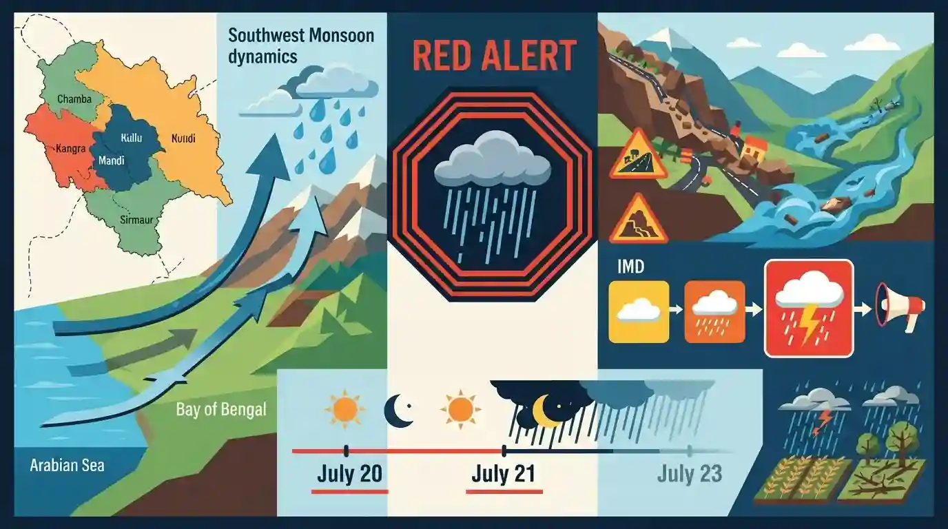
The India Meteorological Department (IMD) issued a high-priority Red Alert warning of extremely heavy rainfall in several districts of Himachal Pradesh (including Chamba, Kangra, Mandi, Sirmaur, and Kullu) from July 20 to July 21, 2026. Part of an active monsoon spell stretching until July 23, the prolonged rainfall brings severe threats of landslides, flash floods, and agricultural damage, particularly to the state's critical mid-hill and low-hill terrains.
Key Points
- The India Meteorological Department (IMD) issued a Red Alert for July 20 and 21, 2026, forecasting extremely heavy rainfall in mid-hill and low-hill districts of Himachal Pradesh, including Chamba, Kangra, Mandi, Sirmaur, and Kullu.
- Orange Alerts were issued for Shimla, Hamirpur, Una, and Bilaspur, indicating heavy to very heavy precipitation during the active monsoon spell spanning July 18 to July 23.
- Severe meteorological hazards such as landslides, mudslides, flash floods, waterlogging, and rising river water levels were flagged as primary risks across vulnerable hill tracts.
- Socio-economic impacts highlighted include potential damage to horticultural and standing crops, structural damage, and disruption of essential services and tourist/commuter traffic.
- Safety advisories were extended to locals and tourists, restricting movement near seasonal nullahs, rivers, and landslide-prone zones during the active peak monsoon spell.
Important Terms
India Meteorological Department (IMD)

The principal agency under the Ministry of Earth Sciences responsible for meteorological observations, weather forecasting, and issuing early warnings for natural disasters like cyclones and heavy rainfall.
UPSC context
Crucial for GS Paper 3 (Disaster Management) and GS Paper 1 (Geography), testing early warning systems and institutional frameworks.
Red Alert (IMD Warning)
The highest severity in the IMD’s color-coded warning system. Meaning 'Take Action,' it signals imminent, extremely severe weather posing a significant risk to life and property, necessitating immediate disaster response.
UPSC context
Relevant to GS Paper 3 (Disaster Management), testing knowledge of public safety protocols and hazard risk communication.
Flash Floods
Sudden, highly localized flooding occurring within six hours of intense rainfall or a sudden water release. They feature a high peak discharge, making them highly destructive, especially in steep Himalayan terrains.
UPSC context
Essential for GS Paper 1 & 3, highlighting climate change impacts, hydro-meteorological hazards, and geographic vulnerabilities.
Active Monsoon Spell
A phase of the Southwest Monsoon marked by widespread and heavy rainfall. In mountainous states like Himachal Pradesh, these continuous spells dramatically increase soil saturation, leading to slope instability and landslides.
UPSC context
Highly relevant for GS Paper 1 (Physical Geography) when analyzing Indian monsoon dynamics and regional climate variations.
Prelims Trap
"Rainfall in Himachal Pradesh uniformly increases with altitude, peaking in the Greater and Trans-Himalayan ranges."
Monsoon rainfall actually peaks in the mid-hills (Dhauladhar range) due to orographic lifting. Higher elevations (like Lahaul-Spiti) lie in a rain-shadow zone, making them arid cold deserts.
Static Concepts Connected
What do the IMD's primary color-coded weather warnings signify?
- Yellow (Be Updated): Indicates severely bad weather spanning several days. It is a baseline alert advising authorities and the public to stay aware.
- Orange (Be Prepared): Signifies heavy to very heavy rain (115.6–204.4 mm). Warns of potential power outages, flooding, and commuter disruptions.
- Red (Take Action): Warns of extremely heavy rain (>204.5 mm). Implies an immediate threat to life and property, demanding swift emergency response.
Why do Himachal's mid-hills receive more monsoon rainfall than its higher alpine altitudes?
- Orographic Lifting: Moisture-laden SW monsoon winds are blocked by the Dhauladhar and Pir Panjal ranges, causing intense localized precipitation (e.g., Dharamshala).
- Rain Shadow Effect: Trans-Himalayan regions like Lahaul-Spiti lie on the leeward side of these mountain barriers, receiving negligible monsoon rain (Cold Desert).
- Precipitation Timing: High-altitude alpine regions receive most of their annual precipitation in the form of winter snow brought by Western Disturbances, not summer monsoons.
Cross-Topic Patterns
Himalayan carrying capacity & infrastructure
High-intensity monsoon spells combined with aggressive road widening and run-of-the-river hydro-projects trigger catastrophic landslides, linking GS-1 physical geography directly to GS-3 disaster management.
Apple economy & shifting snowlines
Rising temperatures and erratic monsoons are pushing the optimal apple-growing zones (requiring chilling hours) to higher altitudes, altering the horticultural economy and threatening traditional mid-hill orchards.

Expect a multi-statement question mapping IMD color codes (Orange vs Red thresholds) against Himalayan flash flood vulnerability in 2026.
Linked PYQs · 3
Linked PYQs · 3
- 2023HPAS_PRELIMSGS1
Consider the following statements : (1) The rainiest district in Himachal Pradesh is Kangra. (2) Rainfall in the Alpine region of Himachal Pradesh varies between 300-600 mm. (3) Winter season in Himachal Pradesh extends from October to March. (4) Mandi is the hottest place in Himachal Pradesh. Choose the correct answer from the options given below :
- 2024HPAS_PRELIMSGS1
Arrange the following climatic zones of Himachal Pradesh according to rainfall amount from lowest to highest : (1) Frigid aridic zone (2) Wet temperate zone (3) Humid sub-tropical zone (4) Sub-humid sub-tropical zone Choose the correct answer from the options given below :
- 2025HPAS_PRELIMSGS1
Match List I with List II : | List-I (Code) | List-II (District) | |---|---| | (a) Highest Rainfall (2018 Data) | (i) Shimla | | (b) Second Most Incidents Reported (2024 Crime Data) | (ii) Mandi | | (c) Fourth Highest Population (2011 Census) | (iii) Kangra | | (d) Fourth Largest Area | (iv) Solan | Choose the correct answer from the options given below : Code: (a) (b) (c) (d)
