High wave alert and fishing curbs along the Gujarat coastline
Source:deshgujarat ↗
આ શા માટે મહત્વનું છે
The extensive list of affected ports provides an excellent overview of the coastal geography of Gujarat. Additionally, the phenomena of steep pressure gradients over the Arabian Sea and the roles of maritime monitoring agencies (IMD and INCOIS) link directly to physical geography and disaster management themes tested in the GPSC Prelims.
સારાંશ
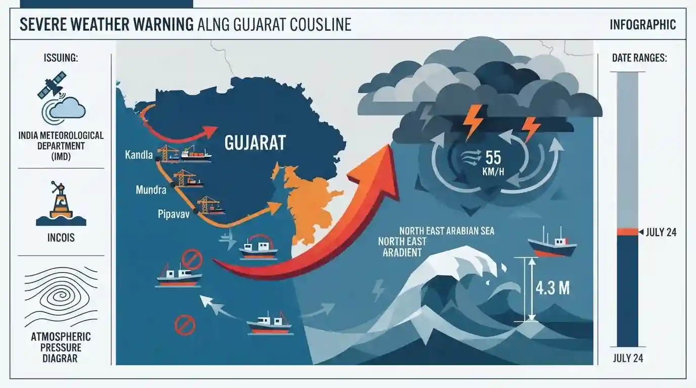
The India Meteorological Department (IMD) and INCOIS have issued a high wave alert and severe warnings for fishermen across the Gujarat coastline due to a steep pressure gradient over the North East Arabian Sea. Squally weather with wind speeds up to 55 km/h and waves measuring up to 4.3 meters are predicted, prompting an advisory against venturing into the sea until July 24. The advisory impacts operations across a vast network of Gujarat's major and minor ports.
મુખ્ય મુદ્દા
- INCOIS has forecasted high ocean waves ranging from 3.5 to 4.3 meters along the Gujarat coast from Jakhau to Diu.
- The IMD issued severe warnings for fishermen operating across South and North Gujarat coasts, advising against entering the sea until July 24.
- A steep pressure gradient over the North East Arabian Sea is driving squally weather with wind gusts expected to reach 55 km/h.
- The warning covers fishermen and maritime activities originating from key major and minor ports of Gujarat including Kandla, Mundra, Navlakhi, Pipavav, and Dahej.
મહત્વપૂર્ણ શબ્દો
India Meteorological Department (IMD)

The principal government agency under the Ministry of Earth Sciences responsible for meteorological observations, weather forecasting, and seismology in India.
UPSC context
Crucial for GS Paper 3 (Disaster Management) and Prelims, testing knowledge on extreme weather forecasting, cyclone warnings, and early warning systems.
Indian National Centre for Ocean Information Services (INCOIS)
An autonomous body under the Ministry of Earth Sciences providing ocean information, advisories, and early warning services for marine hazards like tsunamis and storm surges.
UPSC context
Core GS Paper 3 (Disaster Management) topic; tests knowledge of India's coastal hazard early warning systems and ocean observation networks.
Steep Pressure Gradient
A rapid change in atmospheric pressure over a short distance. On weather maps, it is indicated by closely spaced isobars and results in strong, fast-moving winds.
UPSC context
Fundamental GS Paper 1 (Geography) climatology concept, essential for understanding atmospheric dynamics, wind speeds, and coastal weather hazards.
Squally Weather
A sudden, sharp increase in wind speed that lasts for several minutes, often accompanied by intense, active weather such as rain showers, thunderstorms, and rough seas.
UPSC context
Relevant to GS Paper 1 (Physical Geography) and GS Paper 3 (Disaster Management) regarding coastal hazards and maritime safety advisories.
High Wave Alert
A specialized early warning issued by INCOIS/IMD when ocean wave heights are predicted to breach safe thresholds, posing severe threats to coastal communities and vessels.
UPSC context
Relates to GS Paper 3 (Disaster Management) and Prelims hazard alerts; highlights the application of ocean forecasting systems.
પ્રિલિમ્સ ટ્રેપ
Swell waves (Kallakkadal) are primarily generated by local pressure gradients and coastal wind systems.
Swell waves are surface gravity waves generated by distant meteorological disturbances (like storms in the Southern Ocean) thousands of kilometers away, unlike wind surges which are caused by local coastal winds.
સંલગ્ન સ્થિર ખ્યાલો
How are Major and Minor Ports in India classified and governed constitutionally?
- Constitutional Division: Major Ports are in the Union List (Entry 27) of the Seventh Schedule, while Minor Ports fall under the Concurrent List (Entry 31).
- Governing Laws: Major Ports are governed by the Major Port Authorities Act, 2021; Minor Ports are governed by the Indian Ports Act, 1908 by State Maritime Boards.
- Landlord Model: Major Ports operate under the 'Landlord Port Model', where the public port authority acts as regulator and private players manage operations.
What key technological tools does INCOIS deploy for marine advisory and disaster warning?
- GEMINI Device: A portable receiver utilizing ISRO's GAGAN satellite system to transmit emergency alerts to deep-sea fishermen up to 300 nautical miles.
- PFZ Advisories: Combines chlorophyll data (from ISRO’s OceanSat) and Sea Surface Temperature (SST) from satellites to map high-yield fishing zones.
- Swell Surge Forecast: Predicts devastating Kallakkadal (swell surge) events up to 7 days in advance, generated by distant ocean storms thousands of kilometers away.
આંતર-વિષય પેટર્ન
Satellite Navigation + Marine Safety
The GEMINI device leverages ISRO's GAGAN to bypass terrestrial communication limits, showcasing space-technology integration into disaster risk reduction (DRR) for vulnerable coastal communities.
Federalism in Maritime Infrastructure
The concurrent jurisdiction of minor ports allows states like Gujarat to pioneer private port models, highlighting how cooperative federalism drives maritime trade competition.

2026 Prelims may test INCOIS warning systems (GEMINI/GAGAN) paired with physical oceanography concepts like swell waves vs local surges.
સંલગ્ન PYQ · 2
સંલગ્ન PYQ · 2
- 2025GPSC_PRELIMSGS1
Tropical cyclones do not form near the equator. The main reason for this is 1. Coriolis force is zero. 2. The value of gravity is the lowest. 3. The winds flow at right angle to the Isobar. Select the correct option from the following.
- 2026GPSC_PRELIMSGS1
The term 'Mayday', seen in the news in the context of recent maritime and aviation incidents, refers to:
