Evolution of Tsunami Early Warning Systems in India
Source:The Hindu ↗
Why It Matters
Highlights India's technological and institutional leaps in disaster risk reduction over the past two decades. Directly relevant for GS3 Disaster Management (early warning systems and NDMA guidelines) and GS1 Geography (geophysical phenomena like tsunamis and earthquakes).
Summary
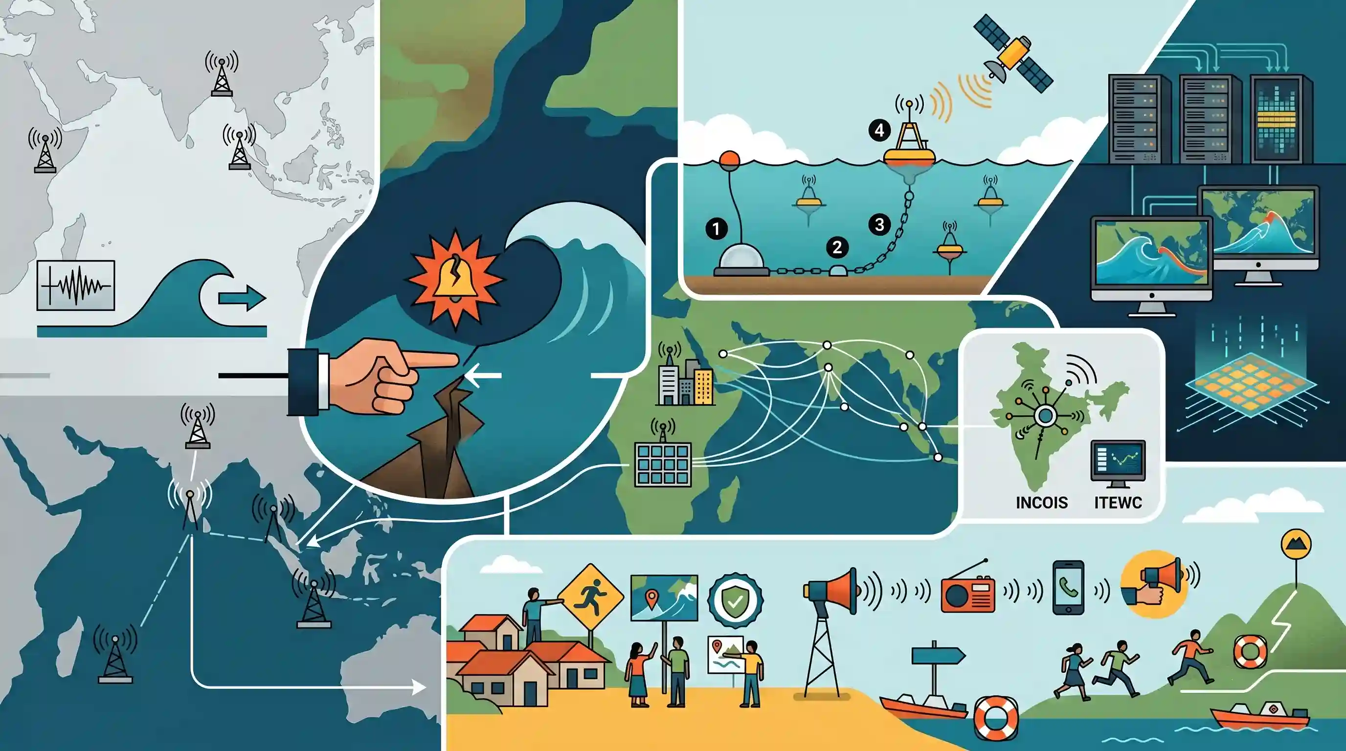
The devastating 2004 Indian Ocean earthquake radically transformed the landscape of tsunami science and disaster mitigation. Prior to the event, the Indian Ocean lacked a dedicated early warning mechanism. The disaster catalyzed the establishment of the Indian Ocean Tsunami Warning and Mitigation System (IOTWMS). In India, the Indian National Centre for Ocean Information Services (INCOIS) spearheaded the creation of the Indian Tsunami Early Warning Centre (ITEWC). Tsunami monitoring advanced from basic seismic detection to the deployment of deep-ocean DART buoys and real-time computational modelling for wave tracking. Today, the focus extends beyond technological forecasting to ensure community-level preparedness through initiatives like the 'Tsunami Ready' programme, ensuring 'last-mile' communication.
Key Points
- The 2004 Sumatra-Andaman earthquake catalyzed a global shift in tsunami science, exposing the lack of early warning systems in the Indian Ocean.
- India established the Indian Tsunami Early Warning Centre (ITEWC) under INCOIS to monitor real-time ocean data and serve as a Regional Tsunami Service Provider.
- Technological interventions moved from relying solely on seismic data to utilizing DART (Deep-ocean Assessment and Reporting of Tsunamis) buoys and coastal tide gauges.
- Advancements in computational modeling now allow for accurate, real-time prediction of tsunami wave propagation, travel time, and coastal inundation, drastically reducing false alarms.
- Disaster risk reduction strategies have expanded to include last-mile connectivity and community preparedness, prominently through the UNESCO-IOC 'Tsunami Ready' certification.
Important Terms
Indian Ocean Tsunami Warning and Mitigation System (IOTWMS)

A regional network established by UNESCO-IOC after the 2004 tsunami to provide real-time alerts and coordinate mitigation strategies among Indian Ocean Rim nations.
UPSC context
GS Paper 3 (Disaster Management) and GS Paper 2 (IR); tests regional cooperation and early warning infrastructure.
Indian National Centre for Ocean Information Services (INCOIS)
An autonomous body under India's Ministry of Earth Sciences (Hyderabad) that provides ocean information, advisories, and operates the national tsunami warning system.
UPSC context
GS Paper 3 (S&T and Disaster Management); focuses on nodal agencies for oceanographic data and hazard monitoring.
Indian Tsunami Early Warning Centre (ITEWC)
A 24x7 operational facility at INCOIS that monitors undersea earthquakes to issue tsunami advisories for India and 28 other Indian Ocean countries.
UPSC context
GS Paper 3 (Disaster Management); relevant for technological interventions and India's role as a regional service provider.
Tsunami Ready Programme
A community-based recognition initiative by UNESCO-IOC that certifies coastal areas for fulfilling specific preparedness indicators like evacuation maps and public awareness drills.
UPSC context
GS Paper 3 (Disaster Management); tests community-level resilience strategies and 'last-mile' connectivity in disaster response.
UNESCO-IOC
The United Nations' primary body for ocean science, responsible for coordinating global tsunami warning systems and promoting international oceanographic cooperation.
UPSC context
GS Paper 2 (International Institutions) and GS Paper 3; relevant for global governance and scientific collaboration.
National Disaster Management Authority (NDMA)
India’s apex statutory body for disaster management, chaired by the Prime Minister, responsible for formulating policies and guidelines for natural and man-made disasters.
UPSC context
GS Paper 3 (Disaster Management); central to the institutional framework for managing disasters under the DM Act, 2005.
Prelims Trap
ITEWC provides tsunami advisories exclusively to Indian coastal states and island territories.
ITEWC at INCOIS acts as a Regional Tsunami Service Provider (RTSP), issuing critical tsunami advisories to 28 Indian Ocean Rim countries, not just India.
Static Concepts Connected
What is the physical mechanism of tsunami generation in subduction zones?
- Megathrust quakes: The oceanic plate subducts under the continental plate; friction causes them to lock, building immense tectonic stress over centuries.
- Vertical displacement: During a rupture, the seafloor snaps upward, vertically displacing a massive column of water from the ocean floor to the surface.
- Shoaling effect: In deep water, waves have huge wavelengths and low height. As they approach shallow coasts, wave speed decreases while height surges drastically.
How does the DART buoy system accurately detect tsunamis?
- Bottom Pressure Recorders (BPR): Placed directly on the seafloor, these sensors measure tiny changes in water column pressure, ignoring surface wind waves entirely.
- Acoustic telemetry: The BPR transmits the pressure anomaly data acoustically through the water column to a specialized buoy on the ocean surface.
- Satellite transmission: The surface buoy instantly relays the real-time data to early warning centers via satellite for precise computational modeling.
Cross-Topic Patterns
Tsunami Ready & Sendai Framework
UNESCO's Tsunami Ready certification is a practical application of the Sendai Framework, emphasizing people-centered, last-mile community disaster preparedness like in Odisha's coastal villages.
INCOIS & Blue Economy Livelihoods
Beyond disasters, INCOIS (MoES) bridges disaster management with marine livelihoods by providing Potential Fishing Zone (PFZ) advisories and ocean state forecasts.

The 2004 Tsunami's 20th anniversary makes INCOIS's regional mandate, DART buoy mechanisms, and UNESCO Tsunami Ready prime 2026 targets.
Linked PYQs · 3
Linked PYQs · 3
- 2017MainsGS3
On December 2004, tsunami brought havoc on fourteen countries including India. Discuss the factors responsible for occurrence of tsunami and its effects on life and economy. In the light of guidelines of NDMA (2010) describe the mechanisms for preparedness to reduce the risk during such events.
- 2025MainsGS1
What are Tsunamis? How and where are they formed? What are their consequences? Explain with examples.
- 2022PrelimsGS1
If a major solar storm (solar flare) reaches the Earth, which of the following are the possible effects on the Earth? 1. GPS and navigation systems could fail. 2. Tsunamis could occur at equatorial regions. 3. Power grids could be damaged. 4. Intense auroras could occur over much of the Earth. 5. Forest fires could take place over much of the planet. 6. Orbits of the satellites could be disturbed. 7. Shortwave radio communication of the aircraft flying over polar regions could be interrupted. Select the correct answer using the code given below:
