Study Warns of High Landslide Risk on Shimla Highway
Source:newindianexpress ↗
Why It Matters
The study highlights critical structural and geological vulnerabilities of NH-5, a vital economic and strategic lifeline for Himachal Pradesh. For HPAS aspirants, it provides key quantitative statistics on landslides, structural engineering mitigation methods (NHAI's slope drainage pipe systems), and environmental concerns regarding Himalayan developmental activities.
Summary
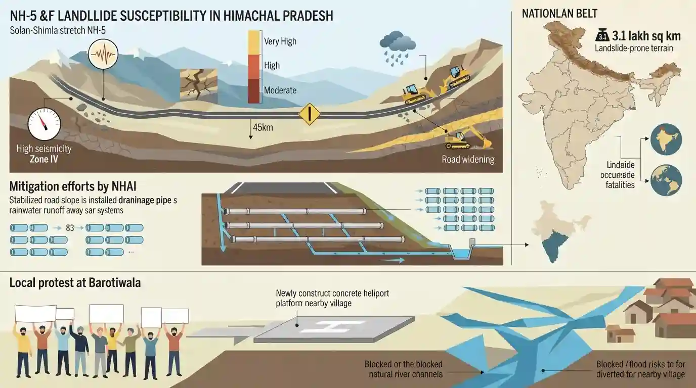
A multi-institutional scientific study published in Springer Nature has warned that nearly 60% of the 45-km Solan-Shimla stretch on National Highway 5 (NH-5) lies in moderate to very high landslide susceptibility zones. The vulnerability of this crucial lifeline to Kinnaur and border areas is exacerbated by high seismicity (Zone IV), fragile Himalayan topography, and heavy monsoons, as well as human-induced factors like slope-toe cutting during road widening. Nationally, the study notes that the Himalayan belt holds 3.1 lakh sq km of landslide-prone terrain, contributing to India's high share of global landslide occurrences and fatalities. To combat this, NHAI has implemented a targeted slope drainage pipe system at 83 vulnerable points to control rainwater runoff. Separately, local protests in Barotiwala (Solan) have emerged over a state-built heliport altering natural river channels and raising local flood risks.
Key Points
- A landslide susceptibility study of the 45-km Solan-Shimla stretch of NH-5 was published in Springer Nature on August 24, 2026.
- The study revealed that nearly 60% of the Solan-Shimla highway stretch falls under moderate to very high landslide susceptibility zones (12.83% very high, 21.97% high, and 26.58% moderate).
- Natural drivers of high landslide vulnerability in the region include steep slopes, Seismic Zone IV positioning, high relative relief, immature Himalayan topography, unstable geological structures, and heavy monsoon precipitation.
- Anthropogenic causes include unscientific road widening (causing toe removal of slopes), extensive deforestation, rapid infrastructure development, and intensive agricultural cultivation.
- According to the study, India accounts for roughly 15% of global landslide occurrences and 31% of landslide-related deaths, with 3.1 lakh sq km of landslide-prone areas located within the Himalayan belt.
- To mitigate landslides, the National Highways Authority of India (NHAI) installed a slope drainage pipe system at 83 vulnerable points on the Parwanoo-Kathlighat stretch of the Kalka-Shimla section, designed to channel rainwater directly to slope bottoms and prevent erosion-inducing runoff.
- In Solan's Barotiwala, local communities raised serious concerns over flood vulnerability, claiming that a boundary wall for a newly constructed heliport by the State Tourism Department has restricted the natural flow of a local river.
Important Terms
National Highways Authority of India

An autonomous agency under the Government of India, responsible for the development, maintenance, and management of the National Highways network, including executing mitigation plans on hazard-prone stretches.
UPSC context
HPAS GS-3 (Infrastructure development) & GS-1 (Disaster management). Tests strategies for resilient hill transport.
Himachal Pradesh State Tourism Department
The state government agency responsible for promoting sustainable tourism, formulating state hospitality policies, and overseeing infrastructure developments like heliports in Himachal Pradesh.
UPSC context
HPAS GS-3 (Tourism Policy) & GS-1 (Environment). Tests balancing civil infrastructure with eco-preservation.
Springer Nature
A leading global academic and scientific publisher that disseminates peer-reviewed research, validating high-level geological studies on land vulnerability and climate hazards.
UPSC context
HPAS GS-3 (Science & Technology). Tests using peer-reviewed scientific data in administrative hazard assessments.
Banaras Hindu University
A prestigious central university in Varanasi, India, whose Earth science and geology departments collaborate on national-level geomorphological and landslide hazard research.
UPSC context
HPAS GS-1 (Himalayan Geomorphology). Tests academic input on regional physical hazards and environmental features.
Kurukshetra University
A premier state university in Haryana, India, active in conducting regional geological and environmental research in the Himalayan and surrounding terrains.
UPSC context
HPAS GS-1 (Natural Hazards). Tests neighboring states' academic involvement in ecological mapping.
Netaji Subhash University of Technology
A prominent state university in New Delhi that provides technical expertise and research capabilities in civil engineering, geotechnics, and slope-stability technology.
UPSC context
HPAS GS-3 (Disaster Mitigation). Tests utilizing engineered and technical solutions for slope and highway stability.
NIIT University
A leading private university in Neemrana, Rajasthan, collaborating on high-technology studies, GIS mapping, and geospatial assessments of landslide-susceptible zones.
UPSC context
HPAS GS-3 (Science & Tech). Tests leveraging advanced GIS systems and corporate-backed academia for mitigation.
Prelims Trap
The Solan-Shimla stretch of NH-5 lies entirely within Seismic Zone V (Very High Damage Risk Zone).
While northern and western parts of Himachal (e.g., Kangra, Chamba) fall under Zone V, the Shimla and Solan districts primarily lie in Seismic Zone IV. Aspirants often overgeneralize the entire state as Zone V.
Static Concepts Connected
How is Himachal Pradesh classified under India's Seismic Zonation?
- Zone V Districts: Chamba, Kangra, Mandi, Kullu, and parts of Lahaul-Spiti and Hamirpur are classified under Zone V (Very High Damage Risk).
- Zone IV Districts: Solan, Shimla, Sirmaur, Kinnaur, Bilaspur, and Una fall majorly under Zone IV (High Damage Risk).
- Tectonic Drivers: The state's high seismicity is driven by active tectonic features like the Main Boundary Thrust (MBT) and Main Central Thrust (MCT).
What are the primary structural methods used for landslide mitigation in hilly terrains?
- Slope Drainage Systems: Using perforated pipes to channel subsurface water out of slopes, reducing pore water pressure (as deployed by NHAI on NH-5).
- Retaining Structures: Constructing concrete breast walls, gabions, and soil nailing to mechanically secure the toe of vulnerable slopes.
- Slope Vegetation: Using vegetation (bio-engineering) to bind topsoil and geo-textiles to control surface erosion.
Cross-Topic Patterns
Infrastructure vs. Carrying Capacity
Unscientific widening of NH-5 highlights the conflict between tourism-led infrastructure and fragile slope geomorphology, emphasizing the need for strict mountain-specific EIAs.
Strategic Lifelines & Border Security
As a primary route to Kinnaur, chronic disruptions on NH-5 due to landslides compromise logistics and troop movement near the Indo-China border.

A GS-3 question on the ecological impact of Himachal's four-laning projects, linking landslide susceptibility to NH-5, is highly probable.
Linked PYQs · 3
Linked PYQs · 3
- 2024HPAS_PRELIMSGS1
Arrange the following climatic zones of Himachal Pradesh according to rainfall amount from lowest to highest : (1) Frigid aridic zone (2) Wet temperate zone (3) Humid sub-tropical zone (4) Sub-humid sub-tropical zone Choose the correct answer from the options given below :
- 2025HPAS_PRELIMSGS1
Mountain Soil Zone in Himachal Pradesh is found between :
- 2017HPAS_PRELIMSGS1
Which of the following Himalayan zones occupies the maximum percentage of total geographical area of H.P. ?
