Sirmaur Landslide and Lahaul Cloudburst Disrupt Himachal Transport
Source:thenewshimachal ↗
Why It Matters
The article highlights the acute susceptibility of the Himalayan ecosystem to natural disasters like landslides and cloudbursts. This is directly relevant to HPAS GS1 (Geography of Himachal Pradesh) and GS3 (Disaster Management) topics, emphasizing the socio-economic and infrastructural impacts of monsoon-induced extreme weather events.
Summary
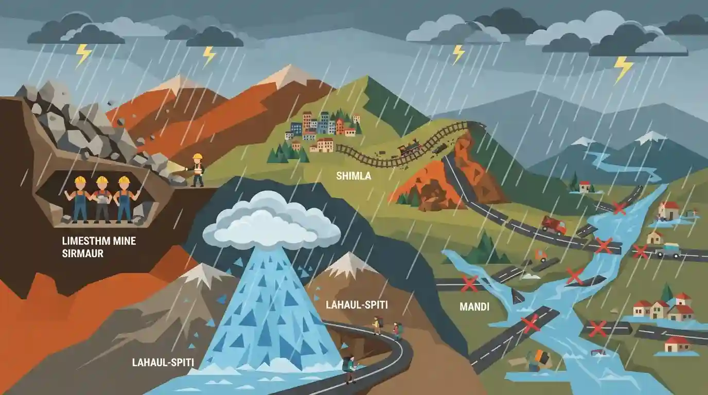
Relentless monsoon rains in Himachal Pradesh continue to wreak havoc, triggering severe landslides, cloudbursts, and flash floods across multiple districts. In Sirmaur, a landslide at a limestone mine trapped three labourers, while a cloudburst in Lahaul-Spiti stranded Neelkanth Yatra pilgrims and damaged road infrastructure. The capital city of Shimla and areas in Mandi have also faced significant disruptions, with 88 roads blocked and heritage rail services suspended. The ongoing disaster underscores the region's extreme vulnerability to climatic hazards, with damages surpassing ₹1,000 crore.
Key Points
- Intense monsoon rains in Himachal Pradesh have led to a cumulative death toll of 197 and financial losses of ₹1,001.72 crore since June 30.
- Three labourers are feared buried under debris following a massive landslide at a limestone mine in the Bangran Dhar area of Sirmaur district's Kafota subdivision.
- A cloudburst and subsequent flash flood in Lahaul-Spiti washed away a crucial road, stranding local farmers and pilgrims undertaking the Neelkanth Yatra.
- Widespread infrastructural damage includes the closure of 88 roads (including NH-3 near Mandi), disruption of 19 drinking-water schemes, and the suspension of four trains on the historic Kalka-Shimla railway line.
Important Terms
Neelkanth Yatra

A high-altitude pilgrimage to Neelkanth Mahadev Lake (4,200m) in the Pattan Valley of Lahaul-Spiti. Dedicated to Lord Shiva, it occurs from July to September and traverses fragile glacial terrain.
UPSC context
HPAS GS Paper 1 (Culture/Geography). Tests awareness of regional heritage pilgrimages and their vulnerability to climate hazards.
Cloudburst
An extreme weather event characterized by highly localized, intense rainfall exceeding 100 mm per hour. In mountainous terrains like Himachal, they rapidly trigger devastating flash floods and landslides.
UPSC context
HPAS GS Paper 3 (Disaster Management). Vital for understanding topographical climate hazards repeatedly impacting Himalayan infrastructure.
India Meteorological Department (IMD)
The principal national agency under the Ministry of Earth Sciences responsible for meteorological observations, weather forecasting, and issuing early weather alerts for public safety during extreme events.
UPSC context
HPAS GS Paper 3 (Disaster Management). Tests knowledge of institutional frameworks providing early warnings for climate-induced disasters.
Kalka-Shimla Railway
A historic narrow-gauge railway built in 1898 connecting Shimla to the northern plains. Recognized as a UNESCO World Heritage site, this crucial route is highly vulnerable to monsoon disruptions.
UPSC context
HPAS GS Paper 1 (Heritage). Tests knowledge of colonial infrastructure, the tourism economy, and climate-induced disruptions on heritage sites.
Limestone Mining in Sirmaur
Extraction of abundant limestone reserves in Sirmaur district, notably around Kafota. The geologically fragile terrain makes these mining zones highly susceptible to fatal collapses and landslides during the monsoon.
UPSC context
HPAS GS Paper 3 (Economy/Environment). Highlights the conflict between resource extraction, regulatory compliance, and ecological vulnerability in hill states.
Prelims Trap
"The Neelkanth Mahadev Lake, affected by recent flash floods, is situated in the Kinnaur district or Uttarakhand."
Aspirants often confuse this lake with the famous Neelkanth peak/temple in Uttarakhand. The Neelkanth Mahadev Lake is a glacial lake in Lahaul-Spiti.
Static Concepts Connected
What is the meteorological mechanism of a 'cloudburst' in the Himalayas?
- Orographic lifting: Moisture-rich monsoon air is rapidly forced upward by steep mountain slopes, cooling and condensing violently.
- Rainfall threshold: Typically defined by the IMD as sudden, extreme precipitation exceeding 100 mm per hour over a localized area of 20-30 sq. km.
- Geological impact: The sudden deluge saturates soil instantly, triggering severe localized flash floods, landslides, and debris flows.
Where are limestone deposits primarily found in Himachal Pradesh, and what is their economic role?
- Key districts: Major commercial deposits are located in the districts of Sirmaur, Bilaspur, Solan, and Kangra.
- Industrial use: It is the primary raw material for the state's robust cement manufacturing industry (e.g., factories in Rajban, Darlaghat).
- Ecological vulnerability: Extensive extraction destabilizes fragile slopes, drastically increasing the region's vulnerability to landslides during heavy rains.
Cross-Topic Patterns
Mountain Railways & UNESCO status
The Kalka-Shimla railway suspension links infrastructure vulnerability to heritage topics. HPAS frequently tests UNESCO sites alongside their geographical or historical settings (e.g., built in 1903).
Unregulated Mining & Disaster Vulnerability
Sirmaur’s limestone mine collapse connects HP's economic geography (mineral extraction) directly to Disaster Management, highlighting human-induced exacerbation of natural hydro-meteorological hazards.

Expect a multi-statement question mapping recent disaster locations (e.g., Neelkanth Lake, Kafota) to their respective districts.
Linked PYQs · 3
Linked PYQs · 3
- 2025HPAS_PRELIMSGS1
Mountain Soil Zone in Himachal Pradesh is found between :
- 2025HPAS_PRELIMSGS1
Match List I with List II : | List-I (Wildlife Sanctuary) | List-II (District) | |---|---| | (a) Kias | (i) Kullu | | (b) Tarla | (ii) Shimla | | (c) Tundah | (iii) Chamba | | (d) Bandli | (iv) Mandi | Choose the correct answer from the options given below : Code: (a) (b) (c) (d)
- 2022HPAS_PRELIMSGS1
Zojila pass is located in :
