हिमाचल राजमार्ग विकास को विनियमित करने के लिए निर्माण नीति की योजना बना रहा है
स्रोत:himachalheadlines ↗
क्यों मायने रखता है
The article highlights the tension between infrastructure development and ecological conservation in the Himalayan region. It is highly relevant for understanding state-level policies on town and country planning, disaster risk reduction (mitigating landslides and floods), and the role of local governance (Gram Panchayats) in environmental mapping.
सारांश
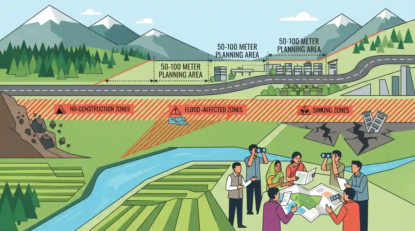
हिमाचल प्रदेश सरकार राजमार्गों के किनारे विकास को विनियमित करने और पारिस्थितिक रूप से संवेदनशील क्षेत्रों की रक्षा के लिए एक नई निर्माण नीति तैयार कर रही है। इस नीति में प्रमुख सड़कों के 50 से 100 मीटर के भीतर 'नियोजन क्षेत्र' (planning areas) बनाने और भूस्खलन-प्रवण, बाढ़ प्रभावित तथा धंसने वाले क्षेत्रों जैसे उच्च जोखिम वाले स्थानों को 'नो-कंस्ट्रक्शन जोन' (गैर-निर्माण क्षेत्र) के रूप में नामित करने का प्रस्ताव है। इस पहल का उद्देश्य संवेदनशील स्थलों की पहचान करने के लिए ग्राम पंचायतों को सशक्त बनाने के साथ-साथ सुरक्षित बुनियादी ढांचे के विस्तार को सुनिश्चित करना है।
मुख्य बिंदु
- हिमाचल प्रदेश सरकार राजमार्गों के दोनों ओर 50 से 100 मीटर को नियोजन क्षेत्र (planning areas) घोषित करके उनके किनारे निर्माण गतिविधियों को विनियमित करने के लिए एक नई निर्माण नीति का मसौदा तैयार कर रही है।
- भूस्खलन-प्रवण क्षेत्रों, बाढ़-प्रभावित क्षेत्रों, धंसाव वाले क्षेत्रों और प्राकृतिक जल निकासी चैनलों को सख्ती से निर्माण-निषिद्ध क्षेत्र (no-construction zones) के रूप में चिह्नित किया जाएगा।
- पारिस्थितिक रूप से नाजुक क्षेत्रों, जैसे कि शिमला में जाखू हिल्स, को बेतरतीब शहरी फैलाव को रोकने के लिए विशेष सुरक्षा प्रदान की जाएगी।
- स्थानीय आपदा जोखिम प्रबंधन को बेहतर बनाने के लिए उच्च जोखिम वाले स्थानों की पहचान करने में ग्राम पंचायतों को शामिल किया जाएगा।
- एक प्रस्तावित मुआवजा तंत्र 'नो-कंस्ट्रक्शन जोन' (निर्माण-निषिद्ध क्षेत्रों) में संपत्ति मालिकों को अपनी जमीन सर्किल दरों पर राज्य सरकार को बेचने की अनुमति दे सकता है।
महत्वपूर्ण शब्द
हिमाचल प्रदेश नगर एवं ग्राम नियोजन अधिनियम, 1977

एक राज्य विधान जो भूमि उपयोग, क्षेत्रीय और सेक्टरल नियोजन, तथा विकास विनियमन को नियंत्रित करता है। यह हिमाचल प्रदेश में अनधिकृत निर्माण को नियंत्रित करने और शहरीकरण के प्रबंधन के लिए वैधानिक ढांचा प्रदान करता है।
UPSC context
Tests GS-2 (State Governance) and GS-3 (Urbanization), highlighting legal frameworks for managing infrastructure in hill states.
नो-कंस्ट्रक्शन जोन
भौगोलिक स्थान—जैसे भूस्खलन-संभावित ढलान, बाढ़ के मैदान, और पुराने डंपिंग स्थल—जहाँ प्राकृतिक आपदाओं को रोकने के लिए नए निर्माण को कानूनी रूप से प्रतिबंधित या अत्यधिक सीमित किया गया है।
UPSC context
Relevant for GS-3 (Disaster Management) and GS-1 (Geography) to illustrate state-level mitigation strategies in sensitive ecologies.
राजमार्ग नियोजन क्षेत्र
राजमार्गों के किनारे 50 से 100 मीटर तक विस्तृत ऐसे चिह्नित क्षेत्र जहां सार्वजनिक सुरक्षा सुनिश्चित करने, रिबन विकास (ribbon development) को रोकने और नागरिक बुनियादी ढांचे के विस्तार को सुगम बनाने के लिए भवन निर्माण को कड़ाई से विनियमित किया जाता है।
UPSC context
Crucial for GS-3 (Infrastructure/Urban Planning) regarding sustainable transport corridors and safe urbanization practices.
ग्राम पंचायतें
ग्राम-स्तरीय स्थानीय स्वशासन संस्थान। पहाड़ी राज्यों में, राज्य नियोजन के लिए उच्च जोखिम वाले, आपदा-प्रवण स्थानों के मानचित्रण हेतु स्थानीय ज्ञान का उपयोग करने के लिए इन्हें सशक्त बनाया जा रहा है।
UPSC context
GS-2 (पंचायती राज) और GS-3 (आपदा प्रबंधन) के लिए महत्वपूर्ण, जो विकेंद्रीकृत, समुदाय-नेतृत्व वाली आपदा तैयारी को रेखांकित करता है।
Ecological Fragility of the Himalayas
चरम मौसम और प्राकृतिक खतरों (भूस्खलन, अचानक आने वाली बाढ़) के प्रति हिमालयी पर्यावरण की अंतर्निहित सुभेद्यता, जो अनियंत्रित निर्माण और वनों की कटाई के कारण आसानी से और भी गंभीर हो जाती है।
UPSC context
GS-1 (भूगोल) और GS-3 (पर्यावरण) की मुख्य अवधारणा, जो पर्वतीय क्षेत्रों में सतत विकास की चुनौतियों के प्रति जागरूकता का परीक्षण करती है।
प्रारंभिक ट्रैप
निर्माण-निषिद्ध पारिस्थितिक रूप से संवेदनशील क्षेत्रों का ज़ोनिंग नेशनल ग्रीन ट्रिब्यूनल या राज्य आपदा प्रबंधन प्राधिकरणों का अनन्य अधिकार क्षेत्र है।
The policy explicitly empowers Gram Panchayats to identify high-risk areas, showcasing decentralization in disaster risk reduction rather than purely top-down NGT/SDMA mandates.
संबंधित अवधारणाएँ
शहरी पारिस्थितिकी के संदर्भ में 'वहन क्षमता' (Carrying Capacity) क्या है?
- परिभाषा: पर्यावरण को अपूरणीय क्षति पहुँचाए बिना किसी क्षेत्र द्वारा वहन की जा सकने वाली मानव आबादी, गतिविधि और बुनियादी ढांचे का अधिकतम स्तर।
- Himalayan relevance: Frequent landslides and land subsidence (e.g., Joshimath) occur when unregulated construction exceeds the geological and ecological limits of hill towns.
- न्यायिक अधिदेश: National Green Tribunal and Supreme Court have repeatedly directed Himalayan states to conduct scientific carrying capacity studies before approving master plans.
आपदा प्रबंधन अधिनियम, 2005 स्थानीय स्वशासन संस्थानों को किस प्रकार एकीकृत करता है?
- Statutory role: The Act mandates local authorities (Panchayats/Municipalities) to ensure capacity building, preparedness, and training at the grassroots level.
- Operational integration: वे प्रथम प्रतिक्रियाकर्ताओं के रूप में कार्य करते हैं और राहत एवं पुनर्वास कार्यों के निष्पादन में जिला आपदा प्रबंधन प्राधिकरण (DDMA) की सहायता करते हैं।
- CBDRR पर ध्यान: समुदाय-आधारित आपदा जोखिम न्यूनीकरण (CBDRR) को सुगम बनाता है, जिससे यह सुनिश्चित होता है कि प्रारंभिक चेतावनी प्रणालियाँ और निकासी योजनाएँ स्थानीय भौगोलिक ज्ञान का उपयोग करें।
अंतर-विषय पैटर्न
Himalayan vs. Western Ghats eco-zoning
HP में निर्माण-निषिद्ध क्षेत्रों का ज़ोनिंग पश्चिमी घाट में पारिस्थितिक रूप से संवेदनशील क्षेत्रों (ESA) संबंधी बहस का प्रतिबिंब है, जो उत्तरी भू-धंसाव (जैसे जोशीमठ) को दक्षिणी संरक्षण मॉडलों से जोड़ता है।
73rd Amendment in Climate Resilience
भूस्खलन और बाढ़ क्षेत्रों का मानचित्रण करने के लिए ग्राम पंचायतों को सशक्त बनाना, स्थिर राजव्यवस्था (73वें संशोधन के माध्यम से स्थानीय शासन) को गतिशील आपदा प्रबंधन (समुदाय-आधारित आपदा जोखिम न्यूनीकरण) से जोड़ता है।

हिमालयी राज्यों की वहन क्षमता (Carrying capacity) + विकेंद्रीकृत आपदा मानचित्रण (पंचायतें) के GS3 Mains 2026 में 15-अंकीय प्रश्न के रूप में पूछे जाने की अत्यधिक संभावना है।
संबद्ध PYQ · 2
संबद्ध PYQ · 2
- 2020HPAS_PRELIMSGS1
Which of the following is / are correct about the Himachal Pradesh Town | Country Planning Act-1977? 1. It has been enforced in 55 Planning areas. 2. Planning area constitutes to 1.60 % of the total geographical area of the state. 3. The above act is enforced in 35 special areas of Himachal Pradesh. 4. 2.06% area of the total geographical area of the state comes under special area.
- 2020HPAS_PRELIMSGS1
Read the passage carefully and attempt the question by choosing the most appropriate option: Desertification is a term used to explain a process of decline in the biological productivity of an ecosystem, leading to total loss of productivity. While this phenomenon is often linked to the arid, semi-arid and sub-humid ecosystems, even in the humid tropics, the impact could be most dramatic. Impoverishment of human-impacted terrestrial ecosystems may exhibit itself in a variety of ways; accelerated erosion as in the mountain regions of the country, salinization of land as in the semi-arid and arid 'green revolution' areas of the country, e.g., Haryana and Western Uttar Pradesh, and site quality decline – a common phenomenon due to general decline in tree cover and monotonous monoculture of rice / wheat across the Indian plains. A major consequence of deforestation is that it relates to adverse alterations in the hydrology and related soil nutrient losses. The consequence of deforestation invariably arise out of site degradation through erosive losses. Tropical Asia, Africa and South America have the highest levels of erosion. The ultimate consequences of site desertification are soil degradation, alteration in available water and its quality and the consequent decline in food, fodder and fuel-wood yields essentials for the economic well beings of rural communities. Accelerated erosion chiefly occurs in __________.
