Himachal Plans Construction Policy to Regulate Highway Development
Source:himachalheadlines ↗
Why It Matters
The article highlights the tension between infrastructure development and ecological conservation in the Himalayan region. It is highly relevant for understanding state-level policies on town and country planning, disaster risk reduction (mitigating landslides and floods), and the role of local governance (Gram Panchayats) in environmental mapping.
Summary
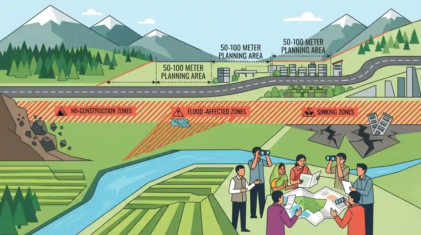
The Himachal Pradesh government is formulating a new construction policy to regulate development along highways and protect ecologically fragile areas. The policy proposes creating 'planning areas' within 50 to 100 meters of major roads and designating high-risk locations—such as landslide-prone, flood-affected, and sinking zones—as 'no-construction zones.' The initiative aims to ensure safer infrastructure expansion while empowering Gram Panchayats to identify vulnerable sites.
Key Points
- The Himachal Pradesh government is drafting a new construction policy to regulate building activities along highways by declaring 50 to 100 meters on either side as planning areas.
- Landslide-prone zones, flood-affected areas, sinking zones, and natural drainage channels will be strictly designated as no-construction zones.
- Ecologically fragile areas, such as the Jakhu Hills in Shimla, will be provided special protection to prevent haphazard urban sprawl.
- Gram Panchayats will be involved in identifying high-risk locations to enhance local disaster risk management.
- A proposed compensation mechanism may allow property owners in no-construction zones to sell their land to the state government at circle rates.
Important Terms
Himachal Pradesh Town and Country Planning Act, 1977

A state legislation governing land use, regional and sectoral planning, and development regulation. It provides the statutory framework for controlling unauthorized construction and managing urbanization in Himachal Pradesh.
UPSC context
Tests GS-2 (State Governance) and GS-3 (Urbanization), highlighting legal frameworks for managing infrastructure in hill states.
No-Construction Zones
Geographical locations—such as landslide-prone slopes, flood plains, and old dumping sites—where new construction is legally prohibited or heavily restricted to prevent natural disasters.
UPSC context
Relevant for GS-3 (Disaster Management) and GS-1 (Geography) to illustrate state-level mitigation strategies in sensitive ecologies.
Highway Planning Areas
Designated zones extending 50 to 100 meters alongside highways where building construction is strictly regulated to ensure public safety, prevent ribbon development, and facilitate civic infrastructure expansion.
UPSC context
Crucial for GS-3 (Infrastructure/Urban Planning) regarding sustainable transport corridors and safe urbanization practices.
Gram Panchayats
Village-level local self-government institutions. In hill states, they are being empowered to utilize local knowledge for mapping high-risk, disaster-prone locations for state planning.
UPSC context
Key for GS-2 (Panchayati Raj) and GS-3 (Disaster Management), highlighting decentralized, community-led disaster preparedness.
Ecological Fragility of the Himalayas
The inherent vulnerability of the Himalayan environment to extreme weather and natural hazards (landslides, flash floods), which is easily exacerbated by unregulated construction and deforestation.
UPSC context
Core GS-1 (Geography) and GS-3 (Environment) concept, testing awareness of sustainable development challenges in mountainous regions.
Prelims Trap
Zoning of no-construction eco-fragile regions is the exclusive domain of the National Green Tribunal or State Disaster Management Authorities.
The policy explicitly empowers Gram Panchayats to identify high-risk areas, showcasing decentralization in disaster risk reduction rather than purely top-down NGT/SDMA mandates.
Static Concepts Connected
What is 'Carrying Capacity' in the context of urban ecology?
- Definition: The maximum level of human population, activity, and infrastructure a region can support without irreversible environmental degradation.
- Himalayan relevance: Frequent landslides and land subsidence (e.g., Joshimath) occur when unregulated construction exceeds the geological and ecological limits of hill towns.
- Judicial mandate: National Green Tribunal and Supreme Court have repeatedly directed Himalayan states to conduct scientific carrying capacity studies before approving master plans.
How does the Disaster Management Act, 2005 integrate local self-government institutions?
- Statutory role: The Act mandates local authorities (Panchayats/Municipalities) to ensure capacity building, preparedness, and training at the grassroots level.
- Operational integration: They act as the first responders and assist the District Disaster Management Authority (DDMA) in executing relief and rehabilitation operations.
- CBDRR focus: Facilitates Community-Based Disaster Risk Reduction (CBDRR), ensuring early warning systems and evacuation plans utilize local geographic knowledge.
Cross-Topic Patterns
Himalayan vs. Western Ghats eco-zoning
The zoning of no-construction areas in HP mirrors the Ecologically Sensitive Areas (ESA) debate in the Western Ghats, linking northern land-subsidence (like Joshimath) with southern conservation models.
73rd Amendment in Climate Resilience
Empowering Gram Panchayats to map landslide and flood zones connects static Polity (local governance via 73rd Amendment) with dynamic Disaster Management (Community-Based Disaster Risk Reduction).

Carrying capacity of Himalayan states + decentralized disaster mapping (Panchayats) is highly probable as a 15-marker in GS3 Mains 2026.
Linked PYQs · 2
Linked PYQs · 2
- 2020HPAS_PRELIMSGS1
Which of the following is / are correct about the Himachal Pradesh Town | Country Planning Act-1977? 1. It has been enforced in 55 Planning areas. 2. Planning area constitutes to 1.60 % of the total geographical area of the state. 3. The above act is enforced in 35 special areas of Himachal Pradesh. 4. 2.06% area of the total geographical area of the state comes under special area.
- 2020HPAS_PRELIMSGS1
Read the passage carefully and attempt the question by choosing the most appropriate option: Desertification is a term used to explain a process of decline in the biological productivity of an ecosystem, leading to total loss of productivity. While this phenomenon is often linked to the arid, semi-arid and sub-humid ecosystems, even in the humid tropics, the impact could be most dramatic. Impoverishment of human-impacted terrestrial ecosystems may exhibit itself in a variety of ways; accelerated erosion as in the mountain regions of the country, salinization of land as in the semi-arid and arid 'green revolution' areas of the country, e.g., Haryana and Western Uttar Pradesh, and site quality decline – a common phenomenon due to general decline in tree cover and monotonous monoculture of rice / wheat across the Indian plains. A major consequence of deforestation is that it relates to adverse alterations in the hydrology and related soil nutrient losses. The consequence of deforestation invariably arise out of site degradation through erosive losses. Tropical Asia, Africa and South America have the highest levels of erosion. The ultimate consequences of site desertification are soil degradation, alteration in available water and its quality and the consequent decline in food, fodder and fuel-wood yields essentials for the economic well beings of rural communities. Accelerated erosion chiefly occurs in __________.
