Chamba Bridge Collapse Strands Pilgrims Amid Himachal Rains
Source:theprint ↗
Why It Matters
Demonstrates the direct impact of climatic and topographical factors on infrastructure and human safety in Himachal Pradesh, serving as a critical real-world case study for geographic vulnerability and disaster management questions in the HPAS Prelims.
Summary
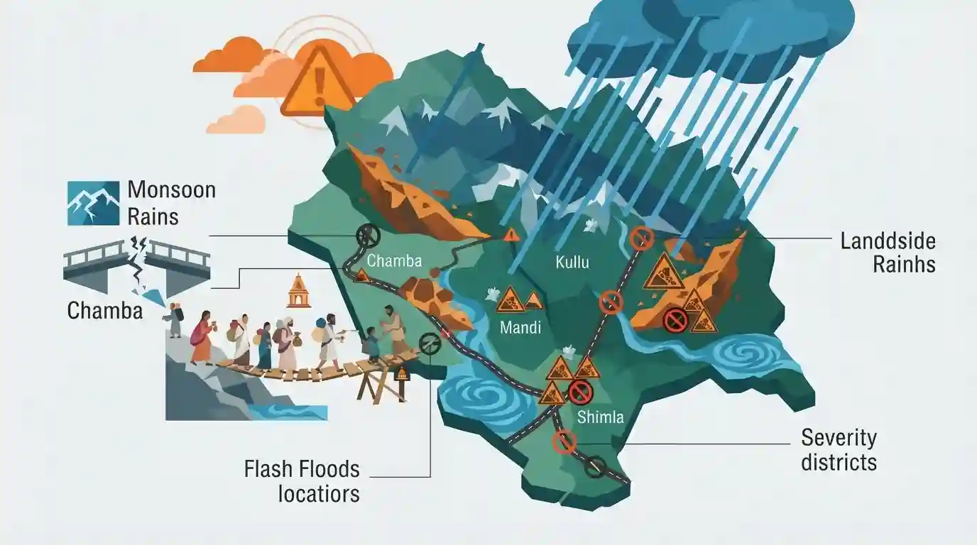
Heavy monsoon rains in Himachal Pradesh triggered widespread landslides and flash floods, leading to the closure of 87 roads across the state. In Chamba district, 50 pilgrims were left stranded after a vital bridge in Bharmaur was swept away, forcing locals to construct a makeshift wooden crossing. Severe road blockages were recorded primarily in the rugged terrain of Kullu, Mandi, and Shimla, underscoring the state's geographic vulnerability. The Meteorological office subsequently issued an orange alert for several other districts, highlighting ongoing severe weather threats.
Key Points
- A rain-induced flood in Bharmaur, Chamba destroyed an iron bridge, temporarily stranding pilgrims headed to the Maa Bhagwati Khundhi Wali temple and Mata Dal Lake.
- Widespread infrastructural disruptions occurred due to heavy rainfall, resulting in the closure of 87 roads, with the highest numbers in Kullu (33), Mandi (27), and Shimla (9).
- The Meteorological office issued an orange alert warning of heavy to very heavy rainfall for four districts: Bilaspur, Kangra, Mandi, and Sirmaur.
- The incident highlights the high vulnerability of Himachal Pradesh's mountainous terrain to natural disasters, where rainfall frequently triggers devastating landslides and flash floods.
Important Terms
State Emergency Operations Centre (SEOC)

A 24x7 nodal command center under the State Disaster Management Authority, typically located in the state secretariat, responsible for real-time disaster monitoring, multi-agency coordination, and early warning dissemination.
UPSC context
GS Paper 3 (Disaster Management). Tests knowledge of institutional frameworks for disaster response in highly vulnerable Himalayan states.
Orange Alert
A weather warning issued by the IMD signifying "Be Prepared." It indicates expected extreme weather—like heavy rainfall (115.6-204.4mm/day)—that has the potential to significantly disrupt daily life and transport.
UPSC context
GS Paper 3 (Disaster Management). Tests understanding of the IMD's color-coded early warning system for extreme weather events.
Manimahesh Yatra
An annual pilgrimage to the high-altitude Manimahesh Lake in the Pir Panjal range of Bharmour, Chamba district. Devotees trek to catch a glimpse of Mount Kailash, believed to be Lord Shiva's abode.
UPSC context
HPAS Pre & GS Paper 1 (Culture of HP). Tests awareness of major state pilgrimages, local geography, and cultural traditions.
India Meteorological Department (IMD)
The principal government agency under the Ministry of Earth Sciences responsible for meteorological observations, weather forecasting, and seismology, including issuing cyclone and monsoon warnings.
UPSC context
GS Paper 1 (Geography) and GS Paper 3 (Disaster Management). Tests awareness of national scientific agencies providing early warnings.
Prelims Trap
"Lama Dal Lake and the associated Manimahesh pilgrimage routes are located in the Kangra district."
While Kangra has a smaller tourist 'Dal Lake' near McLeod Ganj, the large, high-altitude sacred Lama Dal Lake and Mata Dal Lake are in Bharmour, Chamba.
Static Concepts Connected
What are the primary mountain passes connecting Chamba district to neighboring regions?
- Jalsu Pass: The lowest and easiest pass of the Dhauladhar range (3,450m), acting as a vital pedestrian link between Chamba and Kangra.
- Kugti Pass: A demanding, high-altitude pass (5,050m) in the Pir Panjal range that connects the Bharmour region of Chamba to Lahaul and Spiti.
- Baleni Pass: Also known as Minkiani Pass (3,710m), it crosses the Dhauladhar range and acts as a gateway leading to the sacred Lama Dal Lake.
What do the IMD's colour-coded weather alerts indicate for disaster preparedness?
- Yellow Alert: Advises authorities and the public to 'Be Updated' regarding potentially worsening weather conditions over the coming days.
- Orange Alert: Means 'Be Prepared' for severe weather capable of causing major road blockages, power outages, and infrastructural disruptions.
- Red Alert: Signifies 'Take Action' immediately due to extremely bad weather posing a direct, severe risk to life and property.
Cross-Topic Patterns
Climate change vs. Cultural Pilgrimages
Rising extreme precipitation in the Dhauladhars directly threatens ancient trekking routes like Manimahesh, forcing a policy convergence between Disaster Management and the preservation of Cultural Pilgrimages.
Bharmour Geography and Temple Preservation
The geographical isolation of Bharmour (ancient Brahmpura) helped preserve the Chaurasi Temple complex and its 84 shrines, built by early Varman kings, from external invasions during medieval history.

Expect match-the-following questions linking Chamba’s passes (Kugti, Jalsu) or lakes (Lama Dal) to specific pilgrimage or cultural sites.
Linked PYQs · 3
Linked PYQs · 3
- 2020HPAS_PRELIMSGS1
Consider the given four statements and choose the correct answer from the given options. Select the true statements from the following: 1. Chamba, Kullu and Kinnaur are considered the most susceptible of landslide threat. 2. Una, Bilaspur, Sirmaur, Shimla and Solan are considered as low vulnerable of disaster threats. 3. Hum valley of Una district has hardly any natural drinking water source. 4. As per the study of central water board, Kala Amb valley in Sirmaur district has exploited the least underground water.
- 2020HPAS_PRELIMSGS1
Consider the given four statements and choose the correct answer from the given options. Which of the following statement(s) is / are not true? 1. Parangla pass lies between Kinnaur and Lahaul. 2. Manirang is the highest peak of Chamba. 3. Kalichho is the famous lake of Chamba district. 4. Chobia pass lies between Ladakh and Lahaul.
- 2024HPAS_PRELIMSGS1
Consider the following statements : (1) Monkey valley lies in Chamba. (2) Kiarda Dun valley lies in Kangra. (3) The Great Himalayas are referred as Alpine zone in Himachal Pradesh. (4) Churadhar pertain to Zanskar range in Himachal Pradesh Choose the correct answer from the options given below :
