Monsoon Rains Block Roads and Disrupt Services in Himachal
Source:aninews ↗
Why It Matters
The recurring disruption of critical infrastructure like roads, power, and water supply during monsoons underscores the inherent vulnerability of Himalayan states to extreme weather events. It highlights the urgent need for climate-resilient infrastructure planning and robust disaster response mechanisms in Himachal Pradesh.
Summary
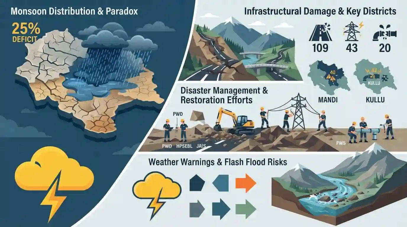
Recent heavy monsoon rains in Himachal Pradesh have caused severe infrastructural damage, blocking 109 roads and disrupting 43 power and 20 water supply schemes. Mandi and Kullu districts are the worst hit, accounting for the majority of the blocked roads. Essential services are being restored by state agencies, including the Public Works Department, HPSEBL, and the Jal Shakti Department. The meteorological department issued a 'yellow' warning for thunderstorms and highlighted flash flood risks in six districts. Paradoxically, despite the localized heavy downpours and resulting infrastructural paralysis, the state faces an overall 25% rainfall deficit for the ongoing monsoon season.
Key Points
- Heavy monsoon rains in Himachal Pradesh have led to the blockade of 109 roads, including the critical National Highway 707 connecting Hatkoti and Paonta Sahib in Sirmaur district.
- Mandi (43 roads) and Kullu (39 roads) districts are the most severely affected by the closures.
- Essential services were significantly disrupted, with 43 power and 20 water supply schemes rendered non-functional, prompting restoration efforts by the HPSEBL and the Jal Shakti Department.
- The regional meteorological office issued a 'yellow' alert for heavy showers, thunderstorms, and lightning across 10 districts, alongside a low flash flood warning for Chamba, Kangra, Kullu, Mandi, Sirmaur, and Shimla.
- Despite the severe disruptions, Himachal Pradesh has recorded an overall rainfall deficit of 25% since the onset of the monsoon on June 1, receiving 420.2 mm compared to the normal 560 mm.
Important Terms
State Emergency Operation Centre (SEOC)

A 24/7 centralized command hub at the state level responsible for coordinating disaster response. It collects early warnings, monitors field situations, and facilitates communication between district administrations, disaster response forces, and central agencies.
UPSC context
Relevant to GS-3 (Disaster Management). Tests understanding of institutional frameworks, early warning dissemination, and state-level emergency response mechanisms.
Meteorological Department
The nodal government agency responsible for weather forecasting, seismology, and meteorological observations. It issues colour-coded alerts, such as yellow or red warnings, to prepare authorities and the public for extreme weather events like flash floods.
UPSC context
Crucial for GS-1 (Geography) and GS-3 (Disaster Management). Tests knowledge of early warning systems, weather forecasting tools, and climate resilience.
Jal Shakti Department
A government department tasked with managing water resources, ensuring drinking water supply, and maintaining sanitation infrastructure. During natural disasters, it leads the rapid restoration of disrupted water supply schemes to prevent public health crises.
UPSC context
Relevant for GS-2 (Governance) and GS-3 (Water Resources). Highlights the role of state infrastructure agencies in disaster recovery and public service delivery.
State Electricity Board
A state-owned utility board responsible for the generation, transmission, and distribution of electricity. It plays a critical role in post-disaster infrastructure recovery by rapidly restoring damaged power grids and distribution transformers.
UPSC context
Covers GS-3 (Infrastructure). Tests awareness of state-level public utilities and their crucial function in maintaining essential public services during crises.
Prelims Trap
"The widespread occurrence of flash floods in a Himalayan state indicates a high seasonal monsoon rainfall surplus."
Aspirants conflate localized extreme rainfall (which causes flash floods) with seasonal surplus. Extreme high-intensity events frequently co-exist with an overall seasonal monsoon rainfall deficit due to climate change.
Static Concepts Connected
What is the Flash Flood Guidance System (FFGS) operated by the IMD?
- Origin & Setup: It is a collaborative system developed by the WMO and US NWS, with IMD serving as the regional center for South Asia.
- Warning Mechanism: It provides watershed-level flash flood risk warnings 6 to 12 hours in advance to disaster management agencies.
- Key Parameters: The system integrates real-time rainfall data, soil moisture index, and surface runoff models to predict sudden flooding.
Why are the Himalayas uniquely susceptible to rain-induced landslides?
- Fragile Geomorphology: They are young fold mountains composed of geologically fragile and unconsolidated sedimentary rocks that are highly prone to mass wasting.
- Extreme Rainfall: High-intensity localized precipitation events quickly saturate the topsoil on steep gradients, instantly triggering debris flows and flash floods.
- Anthropogenic Stress: Unplanned deforestation, slope cutting for highways, and tunneling for hydropower projects disrupt natural drainage lines and severely reduce slope stability.
Cross-Topic Patterns
Climate anomalies + Infrastructure resilience
The paradox of localized floods amidst an overall rainfall deficit highlights 'intra-seasonal precipitation fluctuations', which frequently wash out rural water assets created under schemes like the Jal Jeevan Mission.
Himalayan geomorphology vs infrastructure development
Frequent blockages on critical corridors like NH 707 emphasize the inherent friction between strategic highway expansion and the fragile geomorphology of the young fold mountains.

The paradox of intra-seasonal precipitation fluctuations causing flash floods amidst seasonal rainfall deficits is a prime 2026 exam theme.
Linked PYQs · 3
Linked PYQs · 3
- 2023HPAS_PRELIMSGS1
Consider the following statements : (1) The rainiest district in Himachal Pradesh is Kangra. (2) Rainfall in the Alpine region of Himachal Pradesh varies between 300-600 mm. (3) Winter season in Himachal Pradesh extends from October to March. (4) Mandi is the hottest place in Himachal Pradesh. Choose the correct answer from the options given below :
- 2024HPAS_PRELIMSGS1
Arrange the following climatic zones of Himachal Pradesh according to rainfall amount from lowest to highest : (1) Frigid aridic zone (2) Wet temperate zone (3) Humid sub-tropical zone (4) Sub-humid sub-tropical zone Choose the correct answer from the options given below :
- 2025HPAS_PRELIMSGS1
When was the National Centre for Disaster Management established in India ?
