Rudraprayag Landslides Disrupt Traffic on Char Dham Highways
Source:aninews ↗
Why It Matters
The recurring monsoon-induced landslides highlight the ecological and geological fragility of the Himalayan region, which is a frequent topic in Geography and Disaster Management sections of the UKPSC PCS Prelims. Knowing the exact locations of rivers (Mandakini, Alaknanda) and pilgrimage routes (Kedarnath, Badrinath) within Rudraprayag is crucial for map-based and regional geography questions.
Summary
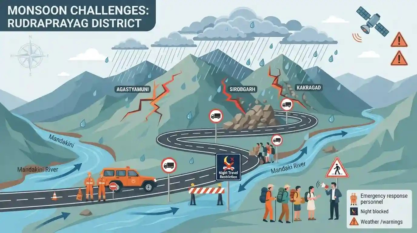
Torrential rainfall in Uttarakhand's Rudraprayag district has caused significant landslides and traffic bottlenecks along the crucial Kedarnath and Badrinath National Highways. Geological instability has resulted in cracks near Agastyamuni and the activation of danger zones at Sirobgarh and Kakragad. With rising water levels in the Mandakini river and the India Meteorological Department issuing further weather warnings, the district administration has stepped up disaster management protocols, urging caution for pilgrims and locals while restricting nighttime travel.
Key Points
- Heavy rains in Uttarakhand have triggered severe landslides, leading to massive traffic disruptions across the Rudraprayag district.
- National Highways leading to major pilgrimage sites like Kedarnath and Badrinath are affected by danger zones created by landslides, specifically around Sirobgarh, Kakragad, and Agastyamuni.
- The District Disaster Management Officer, Nandan Singh Rajwar, reported major cracks developing on the Badrinath National Highway near Agastyamuni.
- Water levels in major rivers such as the Mandakini and Alaknanda are rising, escalating flood risks for riverside settlements and the ongoing Kanwar Yatra.
- The India Meteorological Department (IMD) has issued alerts for continued heavy rainfall, prompting the district administration to restrict night travel and monitor vulnerable mountainous terrains closely.
Important Terms
India Meteorological Department (IMD)

The principal Indian government agency under the Ministry of Earth Sciences, responsible for meteorological observations, weather forecasting, climate services, and early warnings for weather-related hazards.
UPSC context
Important for GS Paper 1 and 3. IMD's forecasts are critical for disaster preparedness, agriculture, and climate governance.
District Disaster Management Authority (DDMA)
Established under the Disaster Management Act of 2005, the DDMA serves as the nodal district-level body for planning, coordinating, and implementing disaster mitigation, preparedness, and response measures.
UPSC context
Crucial for GS-3 (Disaster Management) and GS-2 (Governance), illustrating decentralized, grassroots-level institutional frameworks for disaster response.
Mandakini River
A major Himalayan tributary of the Alaknanda River that originates from the Chorabari Glacier near Kedarnath. It flows through the steep valleys of Rudraprayag before merging with the Alaknanda.
UPSC context
Essential for GS-1 (Geography) and Prelims map-based questions on the Himalayan drainage system and the Panch Prayag.
Sirobgarh Landslide Zone
A notoriously unstable geological stretch in Uttarakhand's Rudraprayag district. It frequently experiences major landslides during monsoons, causing significant blockages along the critical Kedarnath and Badrinath National Highways.
UPSC context
Relevant to GS-1 and GS-3 as a case study highlighting Himalayan geological instability, disaster management challenges, and infrastructure vulnerability.
Prelims Trap
The Mandakini river joins the Bhagirathi river at Rudraprayag to officially form the Ganga.
Mandakini joins the Alaknanda at Rudraprayag. It is the Bhagirathi and Alaknanda that meet at Devprayag to officially form the Ganga river.
Static Concepts Connected
What are the specific river confluences comprising the Panch Prayag?
- Rudraprayag: Confluence of the Alaknanda and Mandakini rivers, a major site on the Kedarnath route.
- Devprayag: Confluence of the Alaknanda and Bhagirathi rivers. Beyond this point, the river is officially called the Ganga.
- Other Prayags: Vishnuprayag (Alaknanda + Dhauliganga), Nandaprayag (Alaknanda + Nandakini), and Karnaprayag (Alaknanda + Pindar).
Why are the Himalayas more susceptible to landslides than the Western Ghats?
- Tectonic activity: They are young fold mountains on active convergent plate boundaries, leading to high seismicity and tectonic instability.
- Geological composition: Composed heavily of loosely consolidated sedimentary and metamorphic rocks, making the steep slopes inherently unstable under heavy rainfall.
- Anthropogenic pressure: Deforestation, unscientific road-cutting, and toe-erosion by fast-flowing rivers disrupt the fragile slope equilibrium.
Cross-Topic Patterns
Infrastructure vs. Himalayan Ecology
Recurrent landslides on pilgrim routes connect physical geography to GS3 themes of carrying capacity and the environmental costs of large-scale infrastructure like the Char Dham project.
ISRO Landslide Atlas mapping
ISRO's Landslide Atlas identifies Rudraprayag as highly vulnerable. UPSC often links space technology applications (GS3) directly to disaster management and vulnerability mapping.

Expect a Prelims match-the-following on Panch Prayag confluences, or a GS3 Mains question on Himalayan carrying capacity.
Linked PYQs · 4
Linked PYQs · 4
- 2025UKPSC_PRELIMSGS1
Which of the following is the correct order of rivers from west to east in Uttarakhand?
- 2025UKPSC_PRELIMSGS1
Which of the following is the correct order of the following physiographic regions of Uttarakhand from south to north direction?
- 2012UKPSC_PRELIMSGS1
In which of the following rivers' confluence is Gobindghat located?
- 2024UKPSC_PRELIMSGS1
Temporary habitats in the high altitude pastures of Garhwal Himalayas are called as
