Heavy rain and landslides disrupt Kedarnath and Mansarovar pilgrimages
Source:rediff ↗
Why It Matters
Highlights the vulnerability of the Himalayan region to hydrometeorological disasters and underscores the logistical challenges and disaster management protocols associated with major religious pilgrimages (Char Dham, Kailash-Mansarovar) in Uttarakhand.
Summary
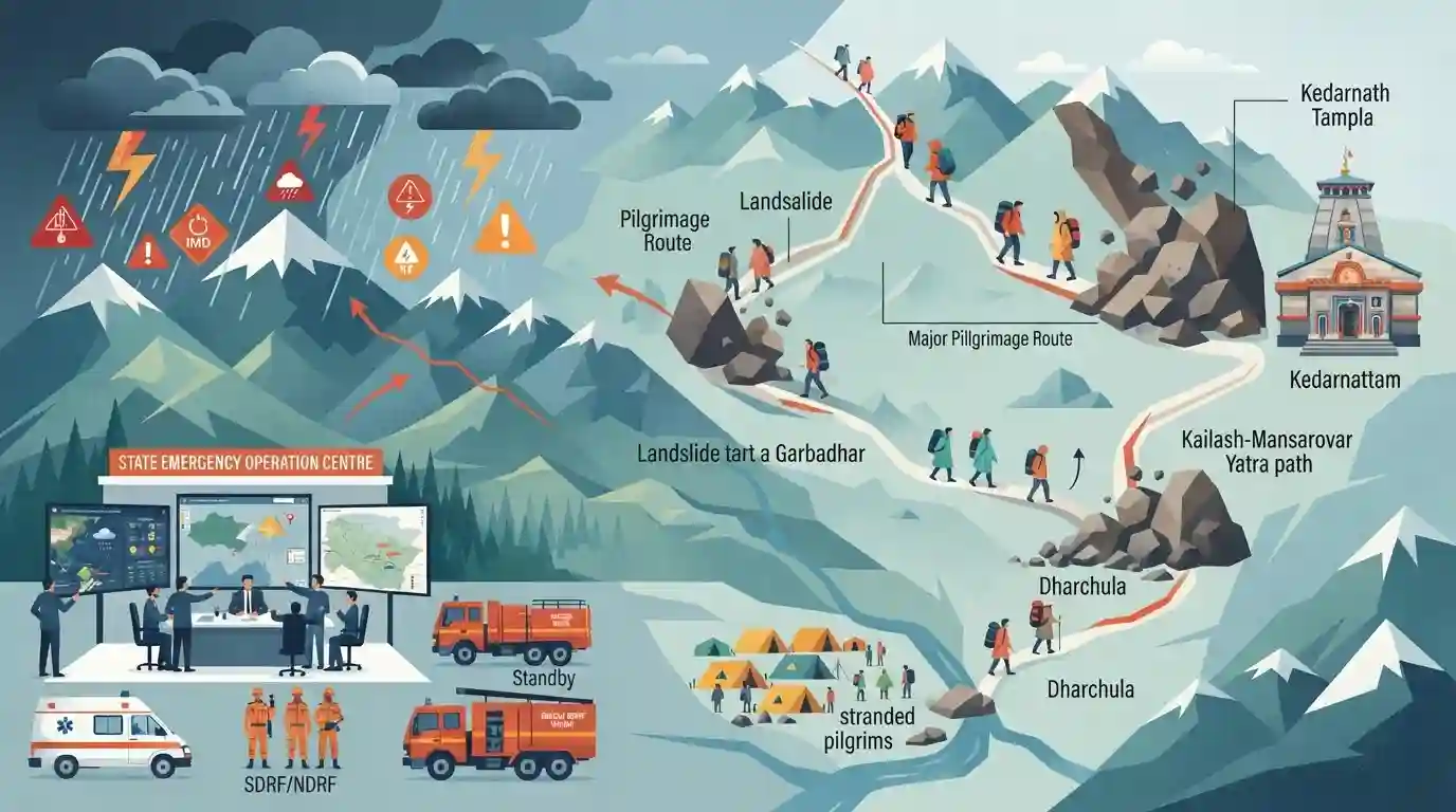
Heavy monsoon rains and resulting landslides in Uttarakhand have caused severe disruptions to major pilgrimages, including the Kedarnath and Kailash-Mansarovar Yatras. The India Meteorological Department (IMD) issued 'red' and 'orange' alerts for extreme rainfall across multiple districts, prompting the State Emergency Operation Centre to instruct local administrations to take precautionary measures and place rescue teams on high alert. Landslides blocked the pedestrian track to Kedarnath and the Gunji route for Kailash-Mansarovar pilgrims at Garbadhar, stranding devotees at base camps such as Dharchula.
Key Points
- The IMD issued severe weather warnings, including 'red' and 'orange' alerts, for extreme rainfall across several districts in Uttarakhand.
- Landslides triggered by heavy rains blocked the Gunji route at Garbadhar, halting Kailash-Mansarovar pilgrims at the Dharchula base camp.
- The Kedarnath pilgrimage was partially disrupted; debris on the pedestrian track between Gaurikund and Kedarnath suspended horse-mule and doli services.
- The State Emergency Operation Centre (SEOC) directed district authorities to maintain high vigilance and keep rescue teams on standby along landslide-prone routes.
Important Terms
Char Dham Yatra

A sacred Hindu pilgrimage circuit in the Uttarakhand Himalayas encompassing four high-altitude shrines: Badrinath, Kedarnath, Gangotri, and Yamunotri.
UPSC context
Relevant to GS Paper 1 (Culture/Geography) and GS Paper 3 (Environmental impact of infrastructure projects in fragile ecologies).
Kailash-Mansarovar Yatra
A transnational pilgrimage to Mount Kailash and Lake Mansarovar in Tibet. Indian routes include the Lipulekh Pass in Uttarakhand and Nathu La in Sikkim, managed by the Ministry of External Affairs.
UPSC context
Important for GS Paper 2 (International Relations/Border Disputes with Nepal) and GS Paper 1 (Geography of Himalayan passes).
India Meteorological Department (IMD)
Established in 1875 under the Ministry of Earth Sciences, it is India's principal agency for weather forecasting, meteorological observations, seismology, and issuing early warnings for natural hazards.
UPSC context
Critical for GS Paper 1 (Climatology) and GS Paper 3 (Disaster Management, early warning systems, and agricultural planning).
State Emergency Operation Centre (SEOC)
The nerve center for coordinating and monitoring disaster response at the state level. It collects early warnings and manages emergency operations in collaboration with district and national authorities.
UPSC context
Essential for GS Paper 3 (Disaster Management framework, institutional mechanisms for mitigation and response under the SDMA).
Yatra Management Force (YMF)
A specialized response force deployed by the Uttarakhand state administration to ensure pilgrim safety, crowd control, and emergency medical assistance during challenging high-altitude treks like the Kedarnath Yatra.
UPSC context
Illustrates localized disaster preparedness and crowd management strategies, relevant for GS Paper 3 (Disaster Management).
Prelims Trap
The Mandakini river meets the Bhagirathi river at Rudraprayag to officially form the Ganges river.
The Mandakini river actually meets the Alaknanda at Rudraprayag. It is the Bhagirathi river that meets the Alaknanda at Devprayag to form the Ganges.
Static Concepts Connected
Which rivers form the Panch Prayag confluences in Uttarakhand?
- Rudraprayag: Confluence of Alaknanda and Mandakini rivers. The Mandakini flows southward from the Chorabari glacier located near Kedarnath.
- Devprayag: Confluence of Alaknanda and Bhagirathi rivers. From this point onwards, the river is officially recognized as the Ganga.
- Upper Confluences: Vishnuprayag (Dhauliganga), Nandaprayag (Nandakini), and Karnaprayag (Pindar) complete the sacred Panch Prayag system on the Alaknanda river.
What is the IMD's color-coded weather warning system?
- Yellow Alert: Severe weather possible; authorities and citizens must keep updated and be aware of potential risks.
- Orange Alert: Preparedness required; potential for significant disruptions to road transport, power lines, and normal life.
- Red Alert: Immediate action necessary; extremely bad weather posing a high risk to life and property is imminent.
Cross-Topic Patterns
Carrying capacity + Himalayan infra
Pilgrimage disruptions tie into broader debates on the ecological carrying capacity of fragile Himalayan states, especially concerning mega-projects like the Char Dham highway.
Strategic border passes + Yatras
The Kailash Mansarovar route via Lipulekh Pass underscores the dual use of border infrastructure for religious tourism and military logistics near the Tibet Autonomous Region.

Expect a 2026 Prelims match-the-following pairing Himalayan pilgrimage sites with their source glaciers (Chorabari) and river confluences.
Linked PYQs · 3
Linked PYQs · 3
- 2007UKPSC_PRELIMSGS1
Which of the following Natural Calamity has the most devastating impact in Uttarakhand State?
- 2025UKPSC_PRELIMSGS1
Consider the following statements and select the correct answer from the options given below : Statement 1 : Uttarakhand is highly vulnerable to climate change. Statement 2 : Climate change is causing water stress and depleting biodiversity in Uttarakhand.
- 2011UKPSC_PRELIMSGS1
A visa is required for Kailash Mansarovar pilgrimage because it is located in
