Nepal Rains Cause Kosi and Gandak Swelling and North Bihar Inundation
Source:timesofindia ↗
Why It Matters
Floods in North Bihar are an annual phenomenon driven by rivers descending from Nepal. The Kosi and Gandak river systems, their associated barrages (Birpur, Valmikinagar), and the socio-economic impacts of floods are high-yield, staple topics for BPSC Prelims Geography and Mains Disaster Management sections.
Summary
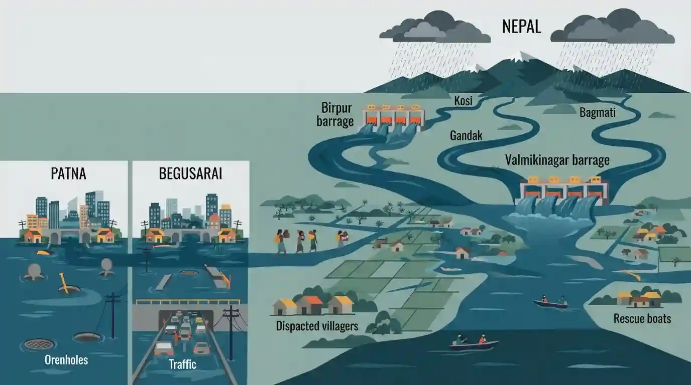
Heavy rainfall in the catchment areas of Nepal has caused major rivers flowing into North Bihar, such as the Kosi, Gandak, and Bagmati, to swell significantly. To manage the high inflow, authorities have opened gates at the Birpur barrage (Kosi) and Valmikinagar barrage (Gandak). This surge has resulted in the inundation of low-lying and riverine areas across districts like Darbhanga and Khagaria. Concurrently, heavy regional showers have exposed poor civic infrastructure, causing severe urban waterlogging in cities including Patna and Begusarai.
Key Points
- Continuous heavy rainfall in Nepal has led to a sharp rise in the water levels of north Bihar rivers, notably the Kosi, Gandak, and Bagmati.
- The Birpur barrage on the Kosi river and Valmikinagar barrage on the Gandak river have opened multiple gates to manage the increased water discharge.
- Low-lying riverine areas, particularly in Darbhanga (Kusheshwar Sthan block) and Khagaria (Alauli block), are facing inundation and flood-like conditions.
- Urban centers such as Patna, Begusarai, and Raxaul are experiencing severe waterlogging due to poor municipal drainage infrastructure amid heavy regional rains.
- Local administrations and the Water Resources Department are monitoring the safety of river embankments closely to prevent breaches.
Important Terms
Kosi River

A transboundary Himalayan river flowing from Nepal into Bihar. Known as the "Sorrow of Bihar" due to its heavy sediment load, frequent channel shifting, and tendency to cause devastating annual floods.
UPSC context
GS1 (Geography). Tests knowledge of Himalayan river systems, drainage patterns, and causes of flood disasters.
Gandak River
A major left-bank tributary of the Ganga originating in Nepal. It enters Bihar near Valmiki Tiger Reserve and is critical for regional irrigation despite posing flood risks during monsoons.
UPSC context
GS1 (Geography). Important for mapping questions, transboundary river systems, and Indo-Nepal hydro-politics.
Birpur Barrage
A key hydraulic structure on the Kosi River near the India-Nepal border. It regulates water for irrigation, but heavy monsoon discharges often trigger downstream flooding in North Bihar.
UPSC context
GS3 (Infrastructure/Disaster Management). Tests understanding of flood control infrastructure, embankment vulnerabilities, and cross-border water management.
Valmikinagar Barrage
A barrage on the Gandak River located at the Indo-Nepal border in West Champaran, Bihar. It supports the Gandak Project's canal systems for irrigation and hydroelectric power generation.
UPSC context
GS1 & GS3. Relevant to water resource management, multi-purpose river valley projects, and bilateral treaties with Nepal.
Urban Flooding
Inundation of heavily populated city areas caused by intense localized rainfall overwhelming inadequate drainage infrastructure. Exacerbated by unplanned urbanization, poor solid waste management, and loss of natural water sinks.
UPSC context
GS3 (Disaster Management). Frequently tested topic focusing on climate change impacts, urban planning, and civic infrastructure resilience.
Water Resources Department (WRD)
The nodal state agency in Bihar overseeing surface water regulation, irrigation projects, and flood management. It monitors river water levels and manages critical infrastructure like embankments and barrages.
UPSC context
GS2 & GS3. Relevant to state-level disaster preparedness, water governance, and infrastructure development.
Disaster Management Department
The state authority responsible for risk mitigation, emergency response, and rehabilitation during calamities like floods. It coordinates relief efforts, including evacuations and operating relief camps.
UPSC context
GS3 (Disaster Management). Tests institutional frameworks for disaster response and implementation of the Disaster Management Act.
Prelims Trap
The Kosi, Gandak, and Bagmati are major right-bank tributaries of the Ganga River originating in the Himalayas.
Kosi, Gandak, and Bagmati are LEFT-bank tributaries of the Ganga. UPSC frequently swaps 'left' and 'right' in statement-based questions to test map precision.
Static Concepts Connected
Why is the Kosi River notorious for frequently shifting its course in Bihar?
- High silt load: It carries immense quantities of alluvium from the Himalayas, depositing it in the plains and rapidly choking its own channel.
- Steep gradient drop: The abrupt transition from steep Himalayan slopes to the exceptionally flat North Bihar plains causes a rapid velocity loss and massive sediment deposition.
- Antecedent drainage: As an antecedent river, it cuts deeply through the Himalayas, bringing huge sediment volumes generated by ongoing tectonic uplift and erosion.
What are the primary anthropogenic causes of urban flooding in Indian cities like Patna?
- Concretization: Extensive paved surfaces dramatically increase surface water run-off and severely restrict natural groundwater infiltration.
- Floodplain encroachment: Illegal construction on natural drainage channels (nalas), wetlands, and historical floodplains removes the city's natural water sinks.
- Poor waste management: Inadequate municipal waste disposal leads to plastic and solid waste heavily choking the existing stormwater drainage networks.
Cross-Topic Patterns
Transboundary rivers & India-Nepal diplomacy
Flood control in North Bihar relies heavily on bilateral cooperation with Nepal. The Kosi and Gandak treaties highlight the critical intersection of India's 'Neighborhood First' policy and domestic disaster mitigation.
Urban vs. Riverine Flooding distinct profiles
UPSC increasingly contrasts rural riverine floods (siltation, embankment breaches) with urban waterlogging (concretization, drainage collapse), treating them as distinct disaster profiles that require tailored NDMA guidelines.

Expect a map-based question matching major Himalayan barrages (Birpur, Valmikinagar) to their respective left-bank Ganga tributaries.
Linked PYQs · 3
Linked PYQs · 3
- 2020BPSC_PRELIMSGS1
Which of the following rivers flowing in Bihar is a north flowing river?
- 2023BPSC_PRELIMSGS1
The other name of river Gandak is
- 2024-IBPSC_PRELIMSGS1
Which river is known as the ‘Sorrow of Bihar’?
