Western Disturbance Rainfall and IMD Weather Forecast in Uttarakhand
Source:dd-india ↗
Why It Matters
Understanding the mechanisms of Western Disturbances, their seasonal occurrence, and their geographic reach is a core requirement for GS Paper 1 Climatology. Additionally, UKPSC frequently tests knowledge of Uttarakhand's district geography, international borders, and physical features like altitudinal variations and plain vs. hilly divisions.
Summary
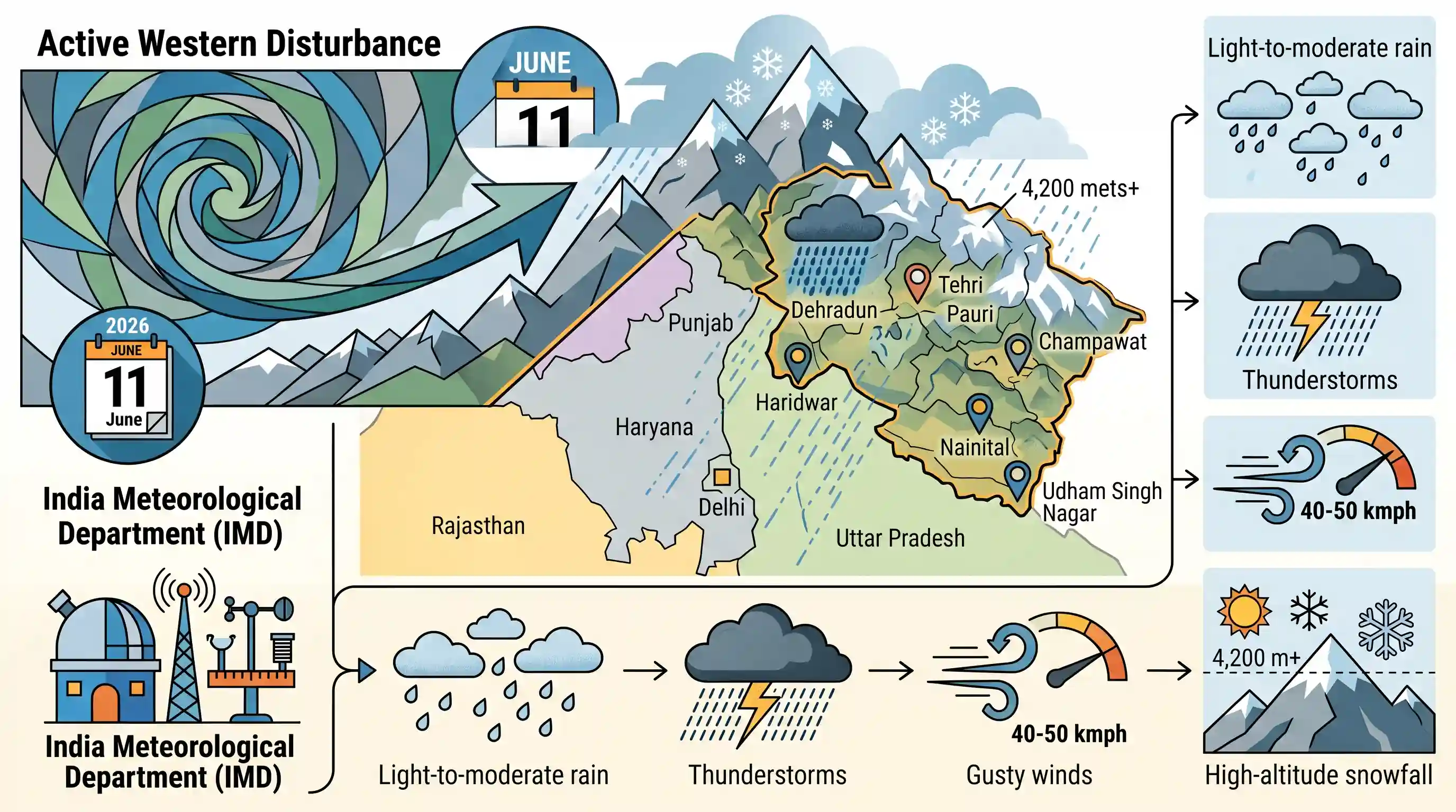
On June 11, 2026, an active Western Disturbance brought heavy rainfall to Dehradun and sparked a prolonged wet spell across Uttarakhand and wider Northwest India. The India Meteorological Department (IMD) forecast light-to-moderate rain, thunderstorms, gusty winds of 40-50 kmph, and snowfall at high altitudes (4,200 metres and above). The weather system impacted several Uttarakhand districts—including Dehradun, Tehri, Pauri, Haridwar, Nainital, Udham Singh Nagar, and Champawat—while expanding precipitation to Punjab, Haryana, Delhi, Uttar Pradesh, and Rajasthan.
Key Points
- An active Western Disturbance brought heavy rainfall and thunderstorms to Dehradun (specifically Garhi Cantt) and several other districts in Uttarakhand, providing relief from severe summer heat.
- The India Meteorological Department (IMD) forecasted light to moderate rain and snowfall at altitudes of 4,200 metres and above across high-altitude regions of Uttarakhand.
- Specific districts highlighted in the weather forecast include Dehradun, Tehri, Pauri, Haridwar, Nainital, Udham Singh Nagar, and Champawat.
- The Western Disturbance also triggered a wider wet spell across Northwest India, spreading rainfall to Punjab, Haryana, Delhi, Uttar Pradesh, and Rajasthan between June 10 and June 14, 2026.
- Severe weather hazards predicted include intense localized rain spells in hill districts, lightning, and gusty winds ranging between 40-50 kmph (and up to 50-60 kmph with hailstorms in some areas).
Important Terms
Western Disturbance

An extra-tropical storm originating in the Mediterranean Sea region that travels eastward, bringing non-monsoonal winter and pre-monsoon precipitation to northwest India and snowfall to the Himalayas.
UPSC context
GS Paper I (Physical Geography — Indian Climate); essential for understanding winter rainfall patterns and its critical impact on Rabi crops.
India Meteorological Department (IMD)
India's principal government agency under the Ministry of Earth Sciences, responsible for meteorological observations, weather forecasting, seismology, and early warnings for weather-related hazards.
UPSC context
GS Paper I (Geography) and GS Paper III (Disaster Management); tests knowledge of national institutional frameworks for climate monitoring.
Orographic Precipitation
Rainfall or snowfall occurring when moisture-laden air is forced to ascend a mountain range, cooling adiabatically, condensing, and shedding precipitation on the windward slope.
UPSC context
GS Paper I (Physical Geography); critical for explaining rainfall distribution patterns across regions like the Western Ghats and Himalayas.
Extratropical Cyclone
A large-scale low-pressure weather system forming in the mid-to-high latitudes (outside the tropics) along frontal zones, steered by jet streams and driven by temperature gradients.
UPSC context
GS Paper I (Climatology); tests the fundamental atmospheric differences between tropical and temperate cyclonic systems.
Prelims Trap
Western Disturbances are strictly winter phenomena and do not occur or cause rainfall during the summer or monsoon seasons.
While most active in winter, WDs occur year-round. Their late-season arrival in May-June can cause severe thunderstorms or interact dangerously with the advancing southwest monsoon.
Static Concepts Connected
What are Western Disturbances and how do they impact Indian climatology?
- Origin and Nature: Extratropical low-pressure systems originating over the Mediterranean Sea that bring crucial non-monsoonal rainfall to Northwest India.
- Steering Mechanism: Driven eastward across West Asia and the Middle East by the high-altitude Subtropical Westerly Jet Stream.
- Agricultural Role: Provide highly beneficial winter precipitation crucial for Rabi crops like wheat, though late-season occurrences can bring crop-damaging hailstorms.
What characterizes Koeppen's Cwg climate type in Northern India?
- Nomenclature Details: Stands for Humid Subtropical climate with dry winters, where 'w' indicates winter dry season and 'g' represents the Ganges temperature pattern.
- Geographical Spread: Dominates the Indo-Gangetic Plains, North-East India, and the outer Himalayan foothills, experiencing wide seasonal temperature fluctuations.
Cross-Topic Patterns
WD-Monsoon interaction and Himalayan hazards
Late-season Western Disturbances interacting with the advancing South-West Monsoon can trigger catastrophic cloudbursts and landslide hazards in the fragile Himalayan terrain.
Westerly Jet Streams and Food Security
Variations in the strength and latitude of the westerly jet stream directly dictate winter precipitation frequency, impacting India's rabi wheat yield and food security.

Western Disturbance mechanisms, jet stream influence, and their year-round anomaly patterns are highly prone to multi-statement MSQ framing.
Linked PYQs · 2
Linked PYQs · 2
- 2024UKPSC_PRELIMSGS1
What percentage (approximately) of Uttarakhand is plain area ?
- 2021UKPSC_PRELIMSGS1
How many districts of Uttarakhand are linked with the international boundaries ?
