Wayanad Rains Trigger Landslide Warnings and Mass Evacuations
Source:The Hindu ↗
কেন এটি গুরুত্বপূর্ণ
This recurring geographical and environmental issue in the Western Ghats frequently forms the basis for UPSC questions concerning landslide vulnerability, the ecological carrying capacity of mountain ecosystems, and the efficacy of India's disaster management strategies.
সারসংক্ষেপ
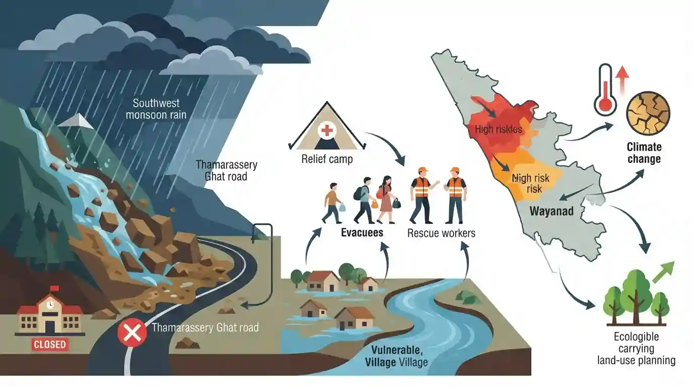
Heavy and persistent rainfall induced by the southwest monsoon has battered Kerala’s Wayanad district, triggering flood and landslip warnings. The district administration initiated swift evacuations, opening relief camps in vulnerable taluks such as Vythiri, Mananthavady, and Sulthan Bathery. With extreme rainfall recorded in areas like Lakkidi and Vythiri, authorities have restricted traffic on the Thamarassery Ghat road and ordered the closure of educational institutions. This recurring crisis highlights the profound vulnerability of the Western Ghats to extreme weather events, bringing to the forefront issues of ecological carrying capacity, sustainable land-use planning, and the implementation of robust disaster mitigation strategies like hazard zonation.
মূল বিষয়
- Intense rainfall driven by the strengthening southwest monsoon caused severe waterlogging, flooding, and threats of landslips in Kerala’s Wayanad district.
- District administration evacuated vulnerable populations to relief camps across high-risk zones, notably in Vythiri, Mananthavady, and Sulthan Bathery taluks.
- Vythiri and Lakkidi regions recorded extreme rainfall within a 24-hour period, reflecting an increasing pattern of intense weather events in the ecologically sensitive Western Ghats.
- Precautionary measures included shutting educational institutions and restricting heavy vehicle and tourist traffic on the vital Thamarassery Ghat road to avert major accidents.
- The incident underscores the urgent need for adherence to the carrying capacity of the Western Ghats, effective hazard zonation mapping, and strict land-use regulations to mitigate landslide risks.
গুরুত্বপূর্ণ শব্দ
National Landslide Risk Management Strategy

A national policy framework launched by NDMA in 2019 to mitigate landslide risks through hazard mapping, real-time monitoring, early warnings, and professional training across highly vulnerable hilly states.
UPSC context
GS Paper III (Disaster Management); tests national policies, mitigation strategies, and Sendai Framework targets.
Hazard Zonation Mapping
A spatial planning tool that divides geographic areas into regions of varying vulnerability (e.g., high, moderate, low risk) to specific natural hazards, enabling safer developmental and land-use planning.
UPSC context
GS Paper I (Geography) and Paper III (Disaster Management); tests land-use planning, risk profiling, and structural mitigation.
District Disaster Management Authority
A statutory body established under Section 25 of the Disaster Management Act, 2005, chaired by the District Collector, responsible for local-level disaster planning, coordination, and response.
UPSC context
GS Paper III (Disaster Management); tests decentralized governance, institutional machinery, and grassroots emergency response mechanisms.
India Meteorological Department (IMD)
Established in 1875 under the Ministry of Earth Sciences, it is India’s principal agency responsible for meteorological observations, weather forecasting, and color-coded severe weather alerts.
UPSC context
GS Paper I (Geography/Monsoons) and Paper III (Disaster Management); tests early warning systems, climate adaptation, and institutional framework.
Ecological Carrying Capacity
The maximum level of population, tourism, or developmental activity that an ecosystem can sustainably support indefinitely without degrading its natural resource base or triggering environmental collapse.
UPSC context
GS Paper III (Environment & Ecology); tests environmental thresholds, sustainable development, and conservation versus development conflicts.
প্রিলিমস ফাঁদ
The Madhav Gadgil Committee recommended designating only 37% of the Western Ghats as an Ecologically Sensitive Area (ESA).
It was the Kasturirangan Committee that proposed the 37% compromise. Gadgil's WGEEP recommended classifying the entire (100%) Western Ghats region as an ESA with varying degrees of protection.
সংযুক্ত স্থির ধারণা
What are the key differences between the Gadgil and Kasturirangan reports?
- ESA Coverage: Gadgil recommended 100% of Western Ghats as Ecologically Sensitive Area, whereas Kasturirangan proposed restricting the ESA designation to only 37%.
- Gram Sabha Power: Gadgil advocated bottom-up environmental democracy with veto power to Gram Sabhas, while Kasturirangan took a top-down approach with regulated developmental exceptions.
- Landscape Classification: Kasturirangan divided the region into natural landscapes (to protect) and cultural landscapes (for regulated development), a distinction absent in Gadgil's framework.
How do Western Ghats and Himalayan landslides geologically differ?
- Tectonic Activity: Himalayan landslides are heavily driven by active seismic factors and young fold-mountain instability; Western Ghats landslides occur on seismically stable, older block mountains.
- Anthropogenic Drivers: Western Ghats slopes fail primarily due to intense monsoonal hydrological load coupled with land-use changes like monoculture plantations and steep road-cutting.
আন্তঃবিষয় প্যাটার্ন
Federalism and ESA Notification
Friction between Center-directed Western Ghats ecological zones and State concerns over land-use reflects the ongoing struggle between federal environmental policies and local economic development.
Disaster Mitigation and Local Economy
Developing GSI's Landslide Early Warning Systems acts as a crucial climate adaptation tool, protecting infrastructure and high-yield tourism sectors in fragile terrains.

Expect a 2026 question contrasting Western Ghats vs Himalayan landslide vulnerability or analyzing the criteria for Ecologically Sensitive Areas.
সংযুক্ত PYQ · 5
সংযুক্ত PYQ · 5
- 2021MainsGS3
Describe the various causes and the effects of landslides. Mention the important components of the National Landslide Risk Management Strategy.
- 2019MainsGS3
Disaster preparedness is the first step in any disaster management process. Explain how hazard zonation mapping will help disaster mitigation in the case of landslides.
- 2021MainsGS1
Differentiate the causes of landslides in the Himalayan region and Western Ghats.
- 2013MainsGS1
Bring out the causes for more frequent occurrence of landslides in the Himalayas than in the Western Ghats.
- 2019MainsGS3
Define the concept of carrying capacity of an ecosystem as relevant to an environment. Explain how understanding this concept is vital while planning for sustainable development of a region.
