Madhya Pradesh monsoon onset and central district rainfall trends
Source:thehitavada ↗
Why It Matters
The monsoonal patterns, arrival dates, wind velocities, and specific localized physical systems of Madhya Pradesh are crucial for physical geography and climatology topics in the MPPSC State Service Prelims. The exam frequently asks questions about MP's climate classification, wind speeds, and regional monsoon branches.
Summary
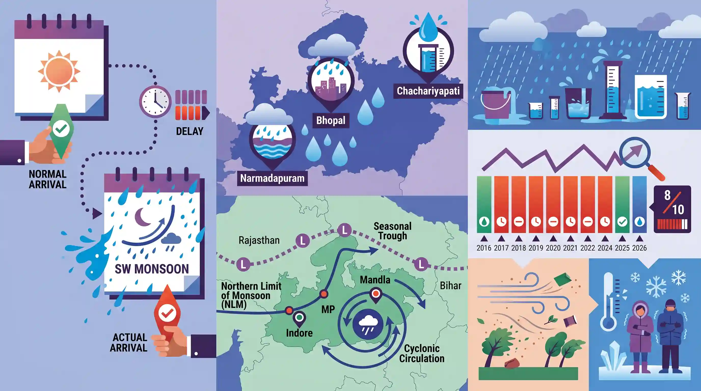
The article highlights the official onset of the Southwest Monsoon over Madhya Pradesh on June 24, 2026, after a 9-day delay from its normal arrival date of June 15. Widespread heavy downpours lashed Bhopal and Narmadapuram divisions, with Chachariyapati recording the highest rainfall of 136 mm. This delayed arrival reflects a growing ten-year volatile trend (2016-2026) in which delayed monsoon entries have become the norm (occurring in eight out of ten years). The monsoonal surge was supported by key synoptic systems, including the Northern Limit of Monsoon (NLM) passing through Indore and Mandla, a seasonal trough extending from Rajasthan to Bihar, and an active cyclonic circulation over central MP, resulting in high-velocity winds and sharp temperature drops across the state.
Key Points
- The Southwest Monsoon officially arrived over Madhya Pradesh on June 24, 2026, marking a nine-day delay from its normal scheduled onset of June 15.
- An analysis of IMD data from 2016 to 2026 indicates a volatile monsoonal trend over the past decade, with early arrivals occurring only in 2020 (one day early) and 2021 (five days early), while the remaining eight years witnessed delayed entries.
- Chachariyapati recorded the highest rainfall at 136.0 mm, followed by Khategaon (125.0 mm), Nepanagar (119.0 mm), and Khargone (117.0 mm), with Bhopal and Narmadapuram divisions receiving the heaviest downpours.
- The temperature plummeted significantly across Bhopal, Indore, and Narmadapuram divisions, with Dhar recording the lowest minimum temperature at 19.0°C, while Nowgong baked at a state-high of 41.5°C.
- The current weather activity is driven by multiple synoptic systems: the Northern Limit of Monsoon (NLM) passing through Indore and Mandla, a seasonal trough from northern Rajasthan to Bihar, and a cyclonic circulation over the northern parts of central MP.
- High-velocity gale-force winds lashed the state, with Sagar recording the highest wind speed at 59 km/h, followed by Bhopal at 52 km/h, and Agar and Jabalpur both at 50 km/h.
Important Terms
Southwest Monsoon

A seasonal wind system blowing from the southwest across the Indian Ocean from June to September, bringing over 70% of India's annual rainfall and driving its agricultural economy.
UPSC context
GS Paper I (Physical Geography) and GS Paper III (Agriculture). Tests understanding of monsoon dynamics and economic impacts.
Northern Limit of Monsoon (NLM)
An imaginary boundary line tracked by the IMD representing the northernmost limit up to which the Southwest Monsoon has advanced on any given day.
UPSC context
GS Paper I (Geography). Tests conceptual understanding of monsoon progression, tracking methodologies, and synoptic weather systems.
Monsoon Trough
A seasonal low-pressure belt (part of the ITCZ) across northern India whose north-south oscillation determines the distribution and breaks of monsoon rainfall.
UPSC context
GS Paper I (Physical Geography). Tests knowledge of seasonal pressure shifts, wind convergence, and regional climate variations.
India Meteorological Department (IMD)
India's principal government agency responsible for meteorological observations, weather forecasting, seismology, and declaring critical events like monsoon onset and withdrawals.
UPSC context
GS Paper I (Geography) and GS Paper III (Disaster Management). Tests institutional frameworks for climate monitoring and agricultural forecasting.
Prelims Trap
The Northern Limit of Monsoon (NLM) is a fixed latitudinal line marking the climatological boundary of the Southwest Monsoon.
The NLM is not a fixed geographic boundary or a static latitudinal parallel. It is a highly dynamic meteorological line of transition that advances day-by-day based on active weather systems.
Static Concepts Connected
What is the Northern Limit of Monsoon (NLM) and how is it determined?
- Definition: It represents the northernmost boundary up to which the Southwest Monsoon has advanced on any given day during its onset phase.
- Key Parameters: IMD determines it based on persistent rainfall over a specific region, steady westerly wind depth, and falling Outgoing Longwave Radiation (OLR) values.
- Nature of Movement: It is highly dynamic, moving northward in surges driven by tropical depressions, cyclonic circulations, or low-pressure troughs.
How do the two branches of the Southwest Monsoon interact over Central India?
- Branch Convergence: The Arabian Sea branch advances northward over the Western Ghats and Deccan, while the Bay of Bengal branch sweeps through the Ganges plains.
- Central India Role: Central India, particularly Madhya Pradesh, acts as the confluence zone where moisture-laden winds from both branches meet, causing widespread rainfall.
- Synoptic Triggers: The presence of an active seasonal trough and low-pressure systems over this region intensifies the convergence and triggers heavy precipitation.
Cross-Topic Patterns
Monsoon delays and cropping patterns
Delayed onsets and intense, short-duration convective storms disrupt traditional kharif sowing windows, forcing farmers to shift crop cycles and stressing micro-irrigation systems.
Synoptic volatility and urban flooding
High-velocity convective gale winds combined with sudden, high-intensity rain events overwhelm storm-water infrastructure in rapidly growing tier-2 urban centers of Central India.

Questions on the synoptic drivers of Indian monsoon (NLM, troughs) and their decadal onset volatility are highly probable for GS-1 2026.
Linked PYQs · 3
Linked PYQs · 3
- 2018MPPSC_PRELIMSGS1
The climate of Madhya Pradesh is
- 2025MPPSC_PRELIMSGS1
Read the following statements regarding the climate of Madhya Pradesh and select the correct answer from the codes given below: 1. Most of the rainfall in the state is received from the monsoon. 2. Wind speed during winters is faster than in summer and rainy seasons. 3. Distance from sea also affects the distribution of monsoon rains in the state. 4. Summer temperature in Pachmarhi is related to the altitude above sea level. Codes:
- 2024MPPSC_PRELIMSGS1
The south-eastern part of Madhya Pradesh receives maximum rainfall from :
