Ethiopian volcanic ash cloud impacts Indian airspace and aviation
Source:The Hindu ↗
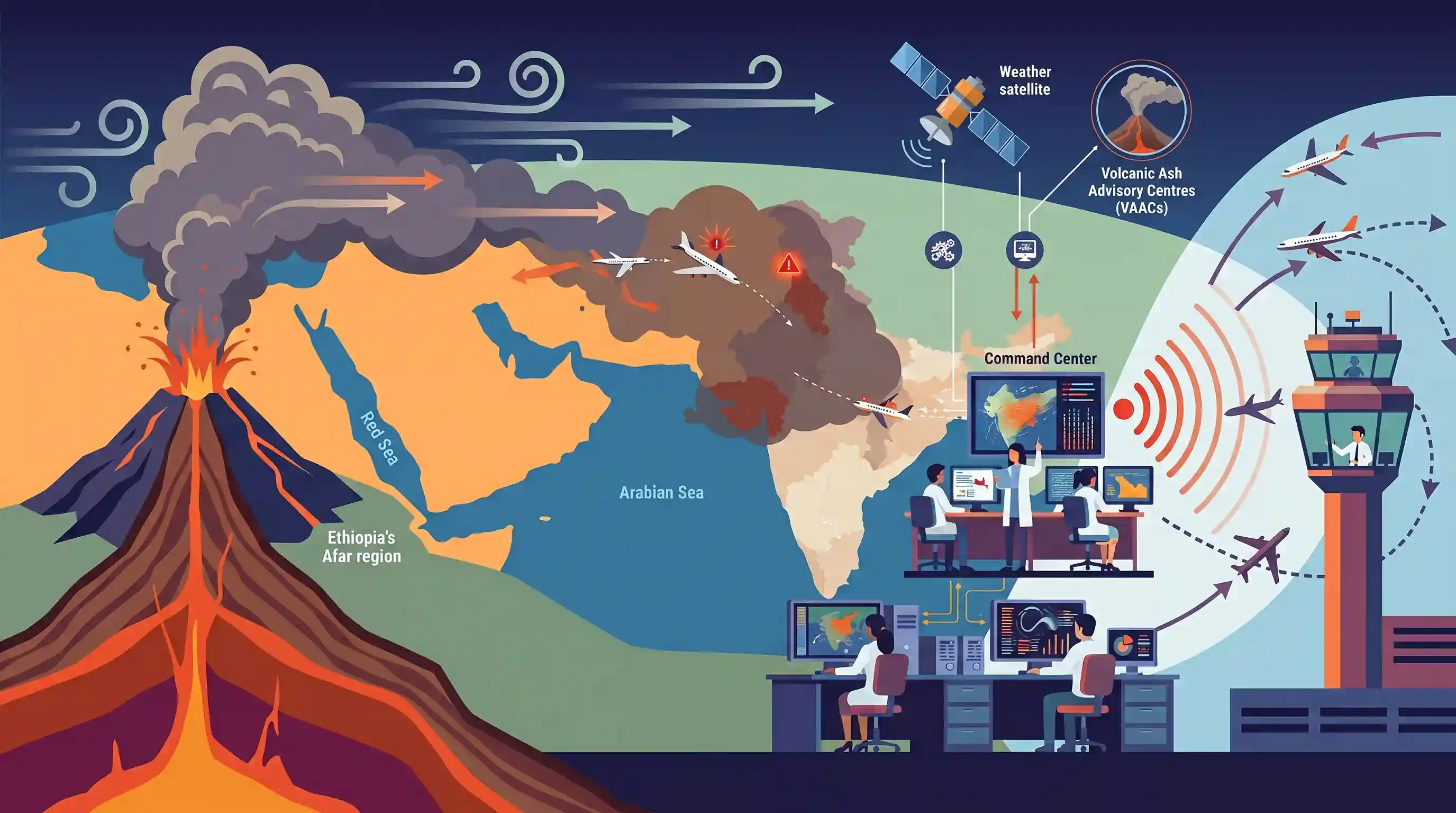
Why It Matters
The event highlights the trans-boundary nature of geophysical hazards, demonstrating how volcanic eruptions in Africa can impact atmospheric conditions and critical sectors like aviation in India via global wind patterns. It is highly relevant for UPSC topics spanning geomorphology, atmospheric circulation, and disaster monitoring mechanisms.
Summary
The recent eruption of the Hayli Gubbi shield volcano in Ethiopia's Afar region generated a massive ash cloud that was carried by high-level winds into Indian airspace, disrupting flight operations. The ash plume traveled across the Red Sea, Arabian Peninsula, and Arabian Sea, affecting states like Gujarat, Delhi-NCR, Rajasthan, Punjab, and Haryana. In response to the aviation hazard, the India Meteorological Department (IMD) tracked the ash dispersion using satellite data and Volcanic Ash Advisory Centres (VAACs) inputs, issuing Significant Meteorological Information (SIGMET) warnings to airports for rerouting and safety management.
Key Points
- The Hayli Gubbi shield volcano in Ethiopia's Afar region erupted, producing an ash plume that reached up to 14 km (45,000 ft) into the atmosphere.
- High-altitude winds carried the volcanic ash cloud eastward across the Red Sea, Arabian Peninsula, and Arabian Sea towards western and northern India.
- The ash plume significantly impacted flight operations in India, necessitating rerouting, extended flight times, and changes to flight planning over several states.
- The India Meteorological Department (IMD) continuously monitored the event using satellite imagery and dispersion models, issuing ICAO-standard Significant Meteorological Information (SIGMET) warnings to ensure aviation safety.
Important Terms
International Civil Aviation Organization (ICAO)

A UN specialized agency that sets global standards for aviation safety, security, and environmental protection. It established the International Airways Volcano Watch (IAVW) to manage volcanic hazards.
UPSC context
Relevant for GS Paper II (International Institutions) and GS Paper III (Disaster Management/Aviation Safety).
Volcanic Ash Advisory Centres (VAAC)
A global network of nine centers responsible for providing real-time information and advisories on the dispersion of volcanic ash clouds to ensure aviation safety.
UPSC context
Important for GS Paper III (Disaster Management) regarding international protocols for natural hazards.
India Meteorological Department (IMD)
India's primary agency for meteorological observations and forecasting. It tracks volcanic ash using satellite data and issues SIGMET warnings to airports and airlines.
UPSC context
Crucial for GS Paper I (Geography - Phenomena) and GS Paper III (Disaster Management).
Significant Meteorological Information (SIGMET)
Weather advisories issued by meteorological watch offices to warn pilots of hazardous weather conditions, such as volcanic ash, that may affect flight safety.
UPSC context
Tests technical knowledge of disaster alerts in GS Paper III (Disaster Management).
Shield Volcano
A type of volcano with broad, gentle slopes formed by the eruption of low-viscosity basaltic lava. Hayli Gubbi is a shield volcano located in Ethiopia's Afar region.
UPSC context
Fundamental concept in GS Paper I (Physical Geography - Volcanism).
Afar Region
A tectonic triple junction in East Africa where the African and Arabian plates are pulling apart, making it one of the most geologically active regions globally.
UPSC context
Key geographical location for GS Paper I (World Geography/Plate Tectonics).
International Airways Volcano Watch (IAVW)
The global monitoring system coordinated by ICAO to detect volcanic activity and warn aircraft of atmospheric ash clouds.
UPSC context
Relevant for GS Paper III (Infrastructure and Disaster Management frameworks).
Prelims Trap
"Shield volcanoes like Hayli Gubbi are characterized by highly viscous lava and violent, explosive eruptions."
Shield volcanoes actually feature highly fluid, low-viscosity basaltic lava. They are generally effusive; massive explosive ash plumes are exceptions (often phreatomagmatic), not their defining trait.
Static Concepts Connected
What tectonic processes are shaping Ethiopia's Afar Depression?
- Triple Junction: It sits at a geological Y-shaped intersection where the African (Nubian), Somali, and Arabian plates are actively pulling apart.
- Divergent Boundary: The rifting causes crustal thinning, widespread basaltic volcanism, and will eventually lead to the formation of a new ocean basin.
How do atmospheric winds transport volcanic ash over intercontinental distances?
- Jet Streams: High-altitude westerly winds and jet streams act as conveyor belts, rapidly transporting ash from East Africa eastward across the Arabian Sea to India.
- Stratospheric Injection: Ash plumes breaching the tropopause (e.g., reaching 14km) evade lower-atmospheric weather systems and rainout, allowing them to linger and travel globally.
Cross-Topic Patterns
Aviation hazards & Disaster Management
Volcanic ash causes jet engine failure by melting silica onto turbine blades. IMD's coordination with VAACs to issue SIGMETs ties physical geography directly to critical infrastructure protection.
Afar rifting & Geoengineering parallels
Sulphur dioxide from high-altitude eruptions reflects sunlight, causing temporary climatic cooling. This natural phenomenon frequently underpins UPSC questions on Solar Radiation Management (SRM) and geoengineering.

Expect a multi-statement Geography question in 2026 pairing the Afar Triple Junction's diverging plates with volcano types.
Linked PYQs · 3
Linked PYQs · 3
- 2024PrelimsGS1
Consider the following: 1. Pyroclastic debris 2. Ash and dust 3. Nitrogen compounds 4. Sulphur compounds How many of the above are products of volcanic eruptions?
- 2021MainsGS1
Mention the global occurrence of volcanic eruptions in 2021 and their impact on regional environment.
- 2014MainsGS1
Why are the world's fold mountain systems located along the margins of continents? Bring out the association between the global distribution of fold mountains and the earthquakes and volcanoes.
