Hayli Gubbi volcano ash cloud impacts Indian airspace
Source:The Hindu ↗
Why It Matters
Demonstrates the transcontinental impact of volcanic eruptions via high-altitude wind currents, and highlights the crucial role of early warning systems and international coordination (like VAACs and IMD) in managing aviation safety during environmental emergencies.
Summary
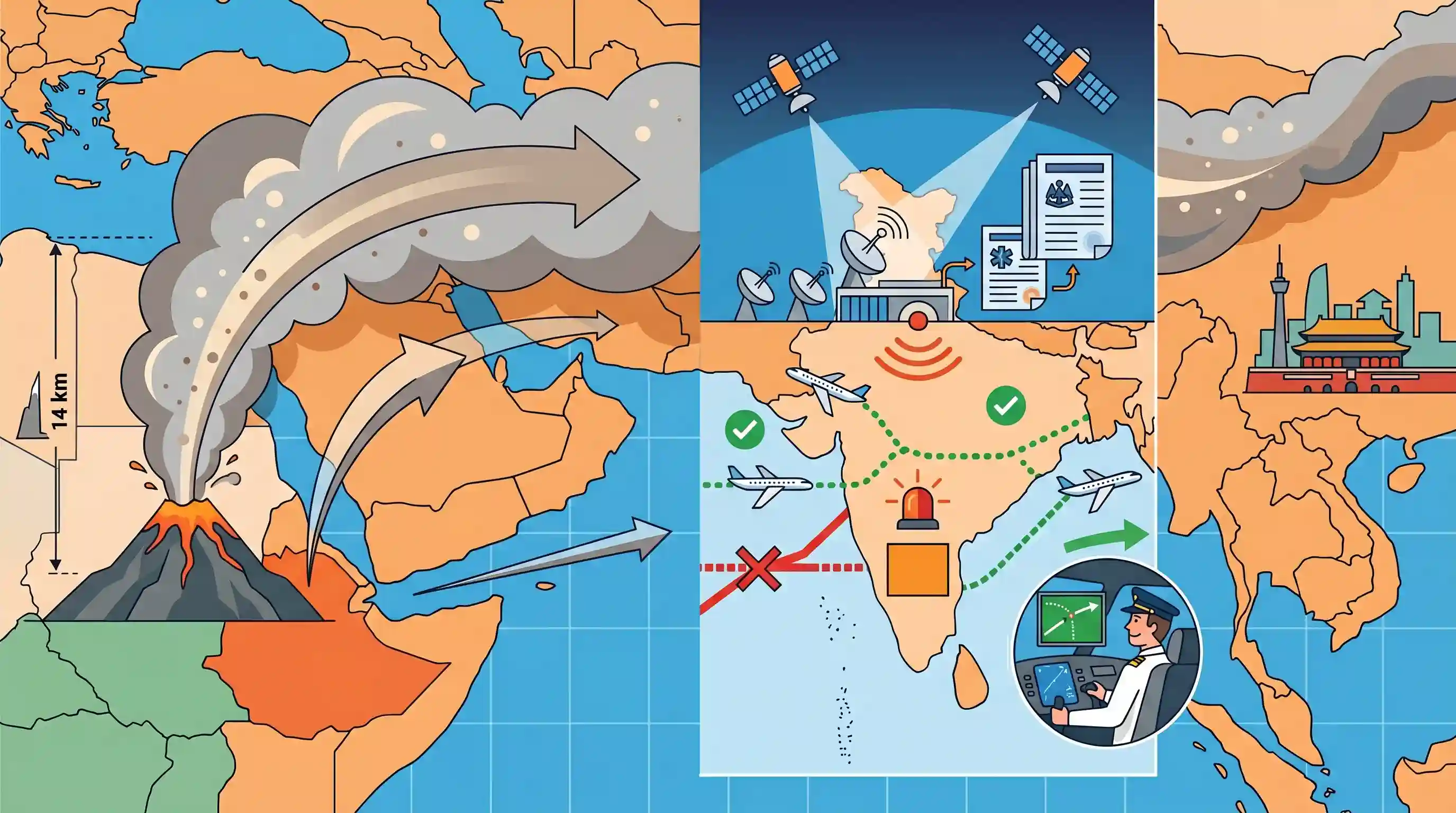
The India Meteorological Department (IMD) tracked ash clouds from the Hayli Gubbi volcano in Ethiopia's Afar region that drifted over the Red Sea and Arabian Peninsula, affecting airspace in western and northern India. High-level winds carried the volcanic ash up to 14 km high, necessitating aviation warnings. The IMD utilized satellite imagery and Volcanic Ash Advisory Centres (VAACs) bulletins to issue SIGMET warnings, allowing airlines to adjust flight paths for safety before the ash eventually drifted towards China.
Key Points
- Hayli Gubbi, a shield volcano in Ethiopia's Afar region, erupted, sending an ash plume up to 14 km into the atmosphere.
- High-level winds transported the ash cloud roughly 3,500 km across the Red Sea and Arabian Peninsula into the airspace over western and northern India.
- The India Meteorological Department (IMD) tracked the ash using satellite imagery, dispersion models, and advisories from Volcanic Ash Advisory Centres (VAACs).
- Met Watch Offices in India issued ICAO-standard SIGMET warnings, allowing airlines to adjust flight planning, safely reroute around affected areas, and manage fuel calculations.
Important Terms
India Meteorological Department (IMD)

The primary Indian government agency under the Ministry of Earth Sciences responsible for weather forecasting, seismic monitoring, and issuing early warnings for natural disasters.
UPSC context
GS Paper 1 & 3: Geography and Disaster Management. Tests knowledge of India's institutional framework for climate monitoring and hazard mitigation.
Significant Meteorological Information (SIGMET)
A concise weather advisory issued to pilots concerning the occurrence or expected occurrence of severe en-route phenomena, such as volcanic ash, that may affect aircraft safety.
UPSC context
GS Paper 3: Disaster Management. Crucial for understanding real-time communication protocols for aviation safety during atmospheric hazards.
Volcanic Ash Advisory Centres (VAACs)
A global network of nine specialized centers tasked with monitoring and forecasting the movement of volcanic ash plumes to provide real-time guidance to the aviation community.
UPSC context
GS Paper 3: Disaster Management. Illustrates international scientific cooperation for monitoring transboundary environmental risks.
International Civil Aviation Organization (ICAO)
A United Nations specialized agency that coordinates international aviation standards and safety protocols, including the management of volcanic ash risks through global watch systems.
UPSC context
GS Paper 2 & 3: International Relations and Disaster Management. Focuses on global governance and regulatory frameworks for aviation safety.
International Airways Volcano Watch (IAVW)
An international system established by ICAO to monitor volcanic activity and issue warnings to ensure aircraft avoid hazardous volcanic ash clouds in the atmosphere.
UPSC context
GS Paper 3: Disaster Management. Highlights the specific global mechanism for mitigating volcanic risks to international air travel.
Prelims Trap
Hayli Gubbi is located at a convergent boundary and is a stratovolcano due to its explosive 14-km ash plume.
The Afar region is a divergent plate boundary (East African Rift). Despite producing an explosive 14-km ash plume, Hayli Gubbi is actually a shield volcano, defying the usual effusive eruption rule.
Static Concepts Connected
How does the tectonic setting of the Afar Triangle influence its volcanism?
- Divergent Boundary: It is situated at a divergent boundary where tectonic movements are actively stretching and splitting the Earth's crust.
- Triple Junction: The region is a classic triple junction where the Arabian, Nubian, and Somali plates are pulling apart from one another.
- Magma Upwelling: Crustal thinning allows mantle magma to upwell easily, typically creating effusive shield volcanoes and widespread basaltic lava flows.
Why is high-altitude volcanic ash a severe hazard for jet aircraft?
- Silica Melting: Ash contains fine, abrasive silica particles that melt at temperatures lower than typical jet engine operating heat (~1,600°C).
- Glassy Deposits: The melted silica re-solidifies into glassy deposits on turbine blades, blocking critical cooling holes and causing complete engine failure.
- Abrasive Damage: Sharp volcanic ash particles act like sandpaper, severely scratching aircraft windshields and disrupting visibility and aerodynamics.
Cross-Topic Patterns
Jet streams and transcontinental aerosols
High-altitude westerly winds transported Ethiopian ash 3,500 km to India, illustrating how upper tropospheric circulation dictates transcontinental aerosol movement, similar to Middle Eastern dust affecting the Indian monsoon.
ICAO framework and aviation disaster management
IMD's use of Volcanic Ash Advisory Centres (VAACs) bulletins highlights the critical role of the ICAO framework in integrating global meteorological data for domestic aviation disaster management.

Expect a Geography question mapping East African Rift features (Afar Triangle, Hayli Gubbi) mixed with divergent boundary mechanisms.
Linked PYQs · 3
Linked PYQs · 3
- 2021MainsGS1
Mention the global occurrence of volcanic eruptions in 2021 and their impact on regional environment.
- 2022MainsGS1
Troposphere is a very significant atmospheric layer that determines weather processes. How?
- 2020MainsGS3
Discuss the recent measures initiated in disaster management by the Government of India departing from the earlier reactive approach.
