Gujarat Crosses Half Of Average Seasonal Rainfall
Source:deshgujarat ↗
આ શા માટે મહત્વનું છે
Understanding the spatial distribution of rainfall across Gujarat's distinct geographic zones (South Gujarat, Saurashtra, Kutch, North Gujarat) is critical for answering geography questions related to climate, agriculture, and water resource management in the GPSC Prelims.
સારાંશ
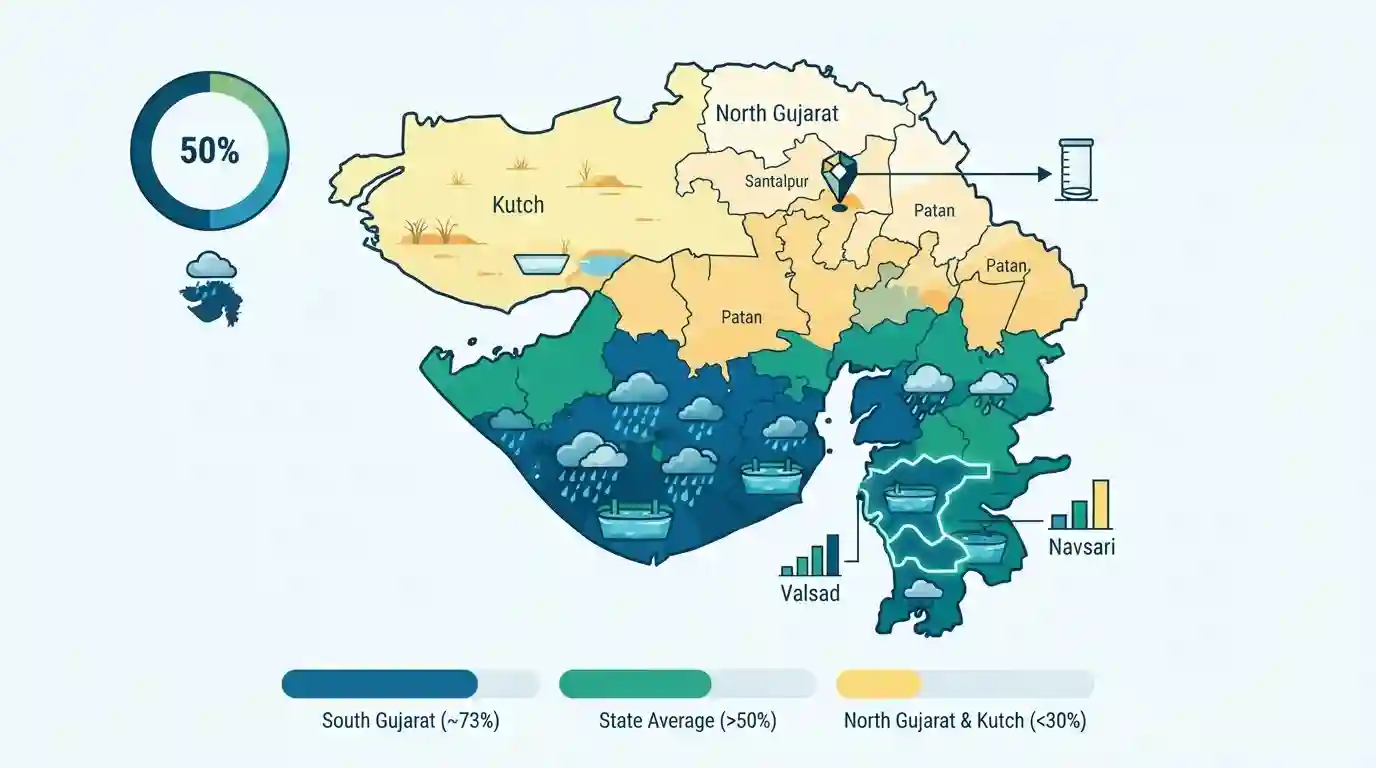
Gujarat has completed over 50% of its average seasonal monsoon rainfall for 2026, according to data from the State Emergency Operation Centre (SEOC) under GSDMA. The distribution highlights stark regional climatic variations: South Gujarat has recorded the highest rainfall at nearly 73%, with top districts like Valsad and Navsari. Conversely, the arid regions of North Gujarat and Kutch lag significantly behind, with Kutch receiving less than 30% and Santalpur in Patan emerging as the lowest-rainfall taluka.
મુખ્ય મુદ્દા
- Gujarat has crossed the 50% mark of its average seasonal rainfall for the 2026 monsoon.
- Rainfall distribution is highly uneven: South Gujarat leads with 72.63% of its seasonal average, while Kutch has received the lowest at 29.28%.
- Saurashtra has recorded 64.91%, East-Central Gujarat 39.81%, and North Gujarat 31.95%.
- The top five talukas receiving the highest rainfall are all located in South Gujarat (Valsad, Navsari, Dang, Surat districts).
- Santalpur taluka in Patan district is the most rain-deficient area in the state so far.
મહત્વપૂર્ણ શબ્દો
Gujarat State Disaster Management Authority (GSDMA)

The statutory nodal agency in Gujarat responsible for disaster preparedness, mitigation, emergency response, and rehabilitation. Established post-2001 Bhuj earthquake, it coordinates statewide risk reduction strategies.
UPSC context
GS Paper 3 (Disaster Management). Tests knowledge of state-level institutional frameworks and risk mitigation strategies.
State Emergency Operation Centre (SEOC)
Gujarat’s central command and control facility for disaster management. Located in Gandhinagar, it coordinates real-time emergency response, manages warnings, and deploys NDRF/SDRF teams during crises.
UPSC context
GS Paper 3 (Disaster Management). Relevant to the role of technology and centralized coordination in rapid disaster response.
Santalpur
A sub-district in Gujarat's Patan district known for its harsh arid climate. Experiencing extremely low monsoon rainfall, it highlights the state's stark spatial climatic variations and susceptibility to drought.
UPSC context
GS Paper 1 (Geography). Excellent case study for micro-regional rainfall disparities and dryland geography in India.
Kutch Arid Region
A vast, hot desert district in northwestern Gujarat featuring saline mudflats (Rann of Kutch) and highly erratic seasonal rainfall. It represents a fragile transitional ecosystem prone to severe water scarcity.
UPSC context
GS Paper 1 & 3. Vital for topics on desertification, regional climatic extremes, and ecosystem conservation.
પ્રિલિમ્સ ટ્રેપ
"Kutch and North Gujarat are arid primarily because they lie in the rain-shadow region of the Aravalli Range."
The Aravallis align parallel to the Arabian Sea branch. They do not block winds to create a rain-shadow; rather, their parallel orientation fails to intercept moisture.
સંલગ્ન સ્થિર ખ્યાલો
What causes stark regional rainfall variations across the state of Gujarat?
- Orographic lift: South Gujarat receives high precipitation as the Arabian Sea monsoon branch strikes the northern edge of the Western Ghats.
- Parallel alignment: The Aravalli range runs parallel to the moisture-bearing winds, failing to intercept clouds and preventing precipitation in North Gujarat.
- Lack of barriers in Kutch: The region remains largely semi-arid due to the total absence of significant geographic barriers to intercept passing monsoon winds.
How did the 2001 Bhuj Earthquake shape India's institutional disaster management framework?
- Pioneering state body: Gujarat established GSDMA in 2001 for proactive disaster management, predating the National Disaster Management Authority (NDMA) created in 2005.
- Shift in approach: It marked a distinct national paradigm shift from reactive, relief-centric approaches to proactive mitigation, preparedness, and structural resilience.
આંતર-વિષય પેટર્ન
West-flowing rivers & urban floods
South Gujarat's extreme rainfall frequently floods steep, west-flowing rivers like the Damanganga, linking regional monsoon climatology directly to urban disaster management and topography.
Paleoclimatology and tectonic shifts
Middle Miocene fossils show Kutch was once a humid forest, providing a classic case study of how geological shifts and continental drift fundamentally alter regional climates.

Expect a multi-statement question on the Arabian Sea monsoon branch, contrasting South Gujarat's flooding with Kutch's aridity.
સંલગ્ન PYQ · 1
સંલગ્ન PYQ · 1
- 2026GPSC_PRELIMSGS1
Consider the following statements regarding the drainage system of Kutch: 1. Most rivers in the Kutch region are ephemeral and non-perennial, carrying water only during the brief monsoon season. 2. The rivers originating from the central hilly tracts of Kutch invariably drain into the Arabian Sea directly. 3. The Luni River, after traversing through Rajasthan, dissipates into the marshy lands of the Rann of Kutch. Which of the above statements are correct?
