New AI Model Maps Planetary Land and Coastal Waters via Remote Sensing
Source:The Hindu ↗
Why It Matters
This development bridges emerging AI technologies with critical environmental and agricultural management. For UPSC aspirants, it serves as a prime example of how e-technology and AI can be leveraged for resource tracking (like water and crops), monitoring climate change effects (deforestation), and solving data management issues in remote sensing—key themes across GS Paper 3.
Summary
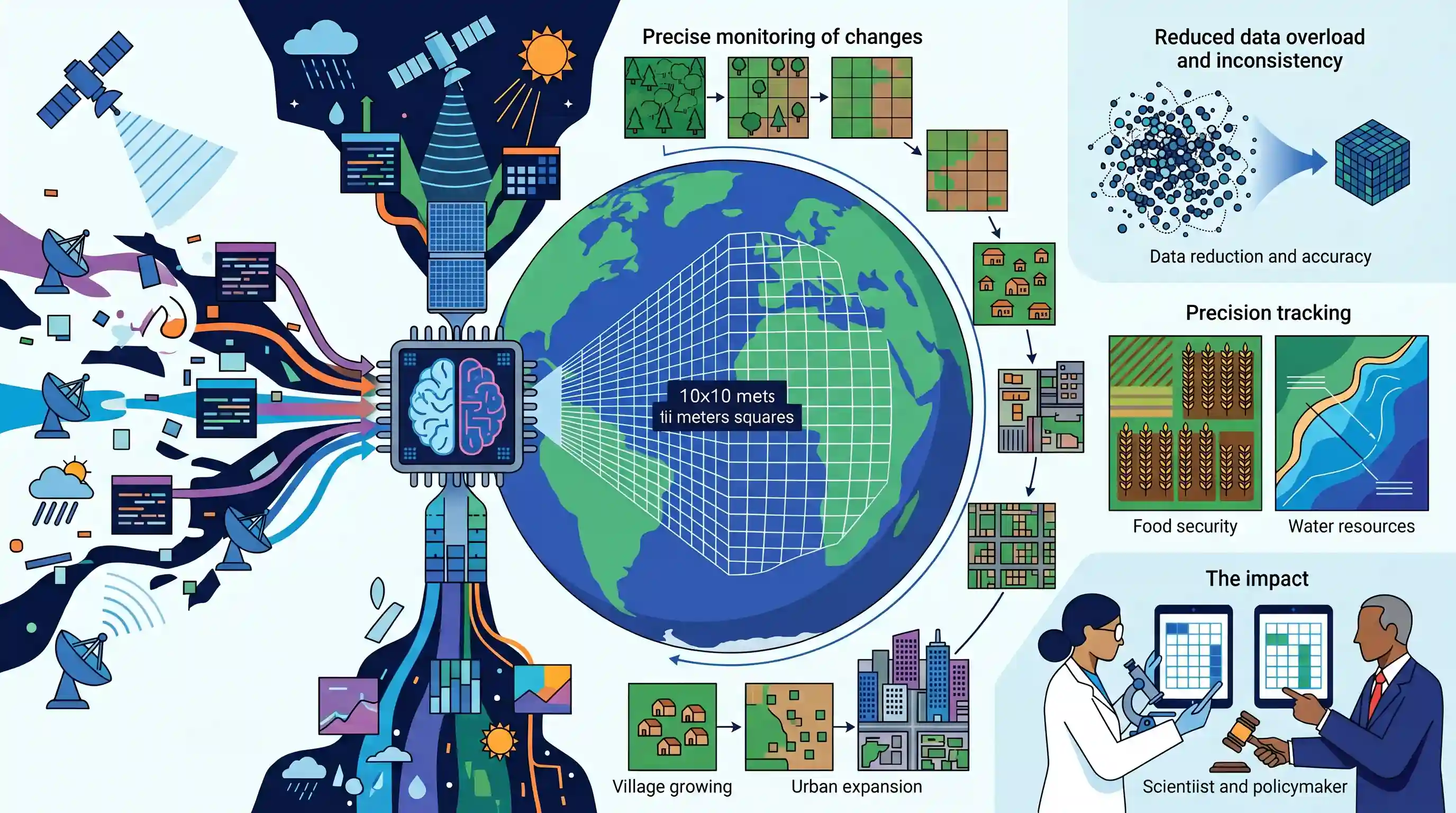
Google DeepMind has unveiled AlphaEarth Foundations, a highly advanced AI model that acts as a 'virtual satellite' to map and analyze global land and coastal waters. By combining vast amounts of fragmented geospatial data—such as satellite images, radar, and climate simulations—the model breaks down the Earth's surface into sharp 10x10 meter squares. This allows for precise monitoring of environmental changes over time. AlphaEarth significantly reduces geospatial data overload and inconsistency, boasting a 24% lower error rate and a 16-fold reduction in storage needs compared to existing models. Its ability to accurately track deforestation, urban expansion, food security, and water resources makes it a groundbreaking tool for scientists and policymakers addressing environmental and resource management challenges.
Key Points
- Google DeepMind introduced AlphaEarth Foundations, an AI model capable of mapping the planet's land and coastal waters with the precision of a virtual satellite.
- The model solves geospatial data inconsistency and overload by synthesizing varied public data sources, including optical satellite imagery, radar, 3D laser mapping, and climate simulations.
- It divides and analyzes the Earth's surface into 10x10-meter squares to track precise changes over time.
- AlphaEarth is designed to assist scientists and policymakers in making informed decisions regarding critical global issues such as food security, deforestation, urban expansion, and water resources.
- The AI model outperforms leading alternatives by achieving a 24% lower error rate while requiring 16 times less storage space.
Important Terms
Remote Sensing

Science of acquiring information about the Earth's surface from a distance, typically via satellites or aircraft, by detecting reflected or emitted electromagnetic radiation.
UPSC context
GS Paper 3: Science & Technology (Space); vital for resource mapping, disaster management, and environmental monitoring.
Geospatial Technology
An umbrella term for tools (GIS, GPS, Remote Sensing) used to collect, analyze, and visualize data associated with specific geographic locations on Earth.
UPSC context
GS Paper 3: Infrastructure and Governance; linked to Digital India, PM Gati Shakti, and the National Geospatial Policy.
Foundation Model (AI)
A large-scale AI model trained on vast, diverse datasets that can be adapted or fine-tuned for a wide range of specific downstream tasks.
UPSC context
GS Paper 3: IT and Electronics; tests knowledge of modern AI architecture and its cross-sectoral applications.
Earth Observation (EO)
The use of remote sensing and ground-based sensors to monitor the Earth's physical, chemical, and biological systems for environmental and climate analysis.
UPSC context
GS Paper 3: Environment/Space; key for tracking climate change, land use patterns, and natural resource conservation.
AlphaEarth Foundations
Google DeepMind's specialized AI model that integrates disparate geospatial data into a high-resolution "virtual satellite" map for precise global environmental monitoring.
UPSC context
GS Paper 3: Science & Tech/Environment; represents the application of AI in solving global environmental data challenges.
Food Security
Ensuring that all people at all times have physical, social, and economic access to sufficient, safe, and nutritious food to meet dietary needs.
UPSC context
GS Paper 2 & 3: Governance/Agriculture; central to poverty alleviation, sustainable development goals, and crisis management.
Prelims Trap
"AlphaEarth is a newly launched Earth observation satellite providing high-resolution global mapping."
AlphaEarth is not a physical satellite; it is an AI software model (a "virtual satellite") that processes and synthesizes existing public remote sensing datasets.
Static Concepts Connected
What is the difference between Active and Passive remote sensing?
- Active Sensors: Emit their own energy to scan objects (e.g., Radar, LiDAR/3D laser mapping). They can operate effectively day and night through cloud cover.
- Passive Sensors: Detect natural radiation emitted or reflected by the target object, such as optical cameras relying on sunlight for imaging.
What are the main applications of remote sensing in agriculture?
- Crop health monitoring: Using multispectral imagery (like NDVI) to assess plant vigor, monitor soil moisture, and detect pest infestations early.
- Yield estimation: Combining spatial data with climate models to map acreages and forecast food grain production, which is crucial for food security.
Cross-Topic Patterns
AI in climate and agriculture
UPSC frequently tests emerging tech applications. AlphaEarth’s fusion of climate simulations and spatial data links AI directly to climate-resilient agriculture and global food security tracking.
Geospatial Policy and Private Tech
India's National Geospatial Policy (2022) liberalized data access. Global AI models utilizing multi-source mapping mirror India's push for domestic digital elevation models and private sector integration.

AI applications in processing remote sensing data for disaster management and agriculture are prime targets for a 2026 multi-statement MCQ.
Linked PYQs · 4
Linked PYQs · 4
- 2019PrelimsGS1
For the measurement/estimation of which of the following are satellite images/remote sensing data used? 1. Chlorophyll content in the vegetation of a specific location 2. Greenhouse gas emissions from rice paddies of a specific location 3. Land surface temperatures of a specific location Select the correct answer using the code given below.
- 2015PrelimsGS1
In which of the following activities are Indian Remote Sensing (IRS) satellites used? 1. Assessment of crop productivity 2. Locating groundwater resources 3. Mineral exploration 4. Telecommunications 5. Traffic studies Select the correct answer using the code given below.
- 2023MainsGS3
Introduce the concept of Artificial Intelligence (AI). How does Al help clinical diagnosis? Do you perceive any threat to privacy of the individual in the use of Al in healthcare?
- 2023MainsGS3
How does e-Technology help farmers in production and marketing of agricultural produce? Explain it.
