Activists Demand Stronger Legal Protection for Aravalli Range
Source:the-statesman ↗
Why It Matters
The Aravalli range is central to Rajasthan's geography and ecology, frequently featuring in RPSC Prelims regarding its role in halting desertification, its mineral wealth, and related environmental conservation challenges. Legal frameworks defining and protecting these fragile ecosystems are critical policy areas.
Summary
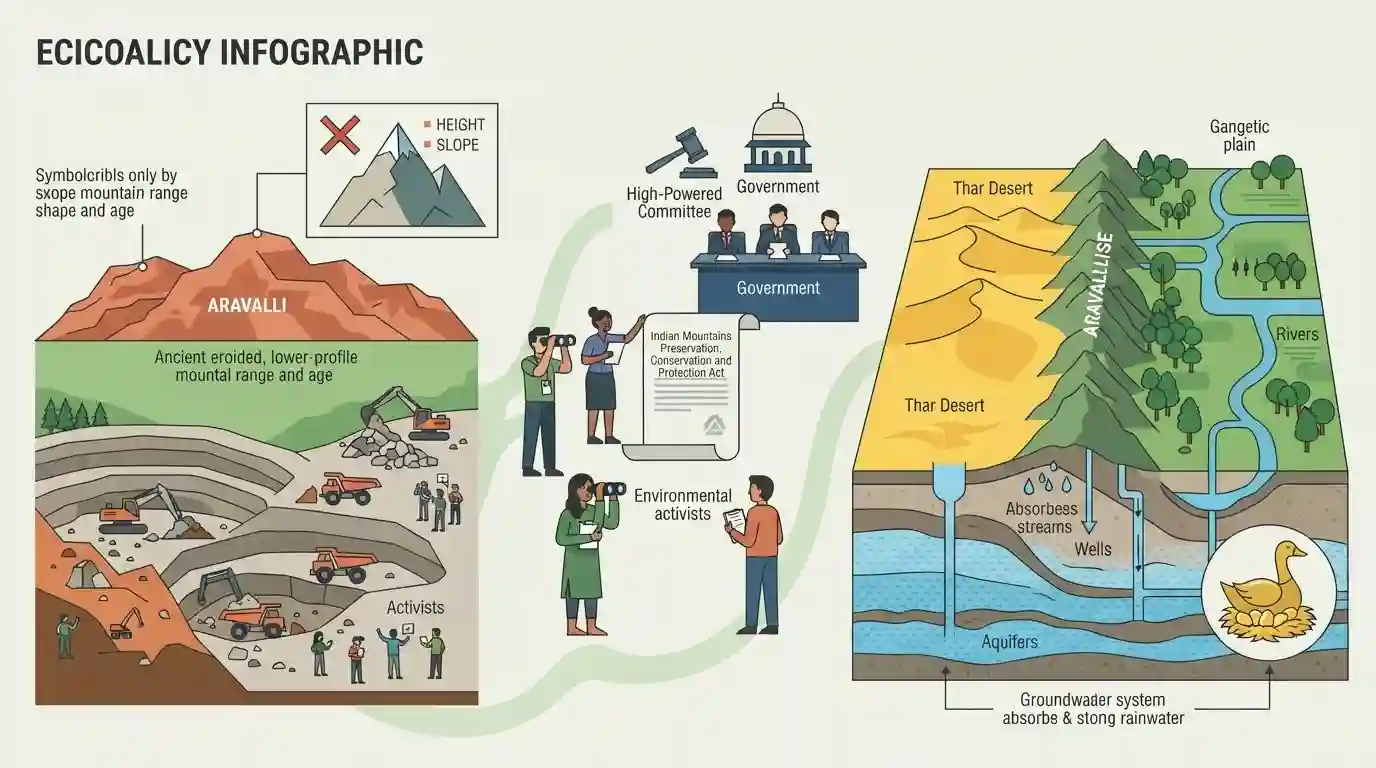
Environmental activists are calling for enhanced legal protection for the Aravalli mountain range, criticizing the current geographical definition of mountains that relies solely on height and slope. They argue this narrow definition leaves older, eroded ranges like the Aravallis vulnerable to rampant mining. Appealing to a Supreme Court-appointed High-Powered Committee and the government, they advocate for a proposed "Indian Mountains Preservation, Conservation and Protection Act." Activists emphasize that the Aravallis serve as a crucial ecological barrier, preventing the Thar Desert's expansion into the Gangetic plain and acting as a major groundwater recharge zone, thereby functioning like the proverbial "goose that lays golden eggs."
Key Points
- Environmentalists are urging the government and a Supreme Court-appointed High-Powered Committee to draft an "Indian Mountains Preservation, Conservation and Protection Act" to safeguard the Aravallis.
- Activists argue that currently, mountains are defined merely by geographical parameters like altitude and slope, which leaves low-elevation ranges like the Aravallis unprotected from mining.
- The Aravalli mountain range spans Gujarat, Rajasthan, Haryana, and Delhi, and acts as a critical ecological barrier against the eastward expansion of the Thar desert into the Gangetic plains.
- Activists describe the Aravallis as a proverbial "goose that lays golden eggs" because they provide essential ecological services such as groundwater recharge and biodiversity conservation, which are compromised by rampant mining.
Important Terms
Indian Mountains Preservation, Conservation and Protection Act (proposed)

A draft legislation prepared by environmental activists to legally protect the Aravallis and other mountain ranges as living entities, aiming to ban destructive mining and reject narrow, elevation-based definitions.
UPSC context
GS Paper 3 (Environment). Tests awareness of proposed governance reforms and civil society efforts for ecological conservation.
High-Powered Committee
A five-member expert panel appointed by the Supreme Court in 2026, headed by the ICFRE Director General, tasked with independently reviewing the scientific and ecological definition and delineation of the Aravalli range.
UPSC context
GS Paper 3 (Environment). Highlights the role of judicial committees in resolving complex conservation issues and regulating mining.
Aravalli Bachao Citizens Movement
A non-partisan, citizen-led campaign launched in 2019 to safeguard the Aravalli mountains from illegal mining, real estate encroachment, and the dilution of protective environmental laws in the National Capital Region.
UPSC context
GS Paper 2 & 3. Illustrates grass-roots environmental activism and citizen participation in safeguarding ecological barriers and biodiversity.
Supreme Court of India
India's apex judicial body, which frequently intervenes in environmental governance, recently ordering a reassessment of the Aravalli range's ecological boundaries and forming a High-Powered Committee to resolve definition ambiguities.
UPSC context
GS Paper 2 (Judiciary) & 3 (Environment). Tests understanding of judicial activism and environmental jurisprudence in India.
Prelims Trap
The Aravalli mountain range spans exclusively across the states of Rajasthan and Haryana.
Aspirants often assume the Aravallis are confined to Rajasthan and Haryana. The range actually spans four entities: Gujarat, Rajasthan, Haryana, and Delhi.
Static Concepts Connected
What is the geographical classification and extent of the Aravalli Range?
- Geological type: Formed as fold mountains in the Precambrian era, they are now highly eroded, making them one of the world's oldest relict/residual mountains.
- Spatial extent: Stretches approximately 692 km southwest to northeast, from Palanpur in Gujarat through Rajasthan and Haryana, ending at the Delhi Ridge.
- Highest peak: Guru Shikhar (1,722m) in Mount Abu, Rajasthan, is the highest point of the range.
- Drainage role: Acts as a major water divide separating the drainage to the Bay of Bengal and Arabian Sea. Source of Banas, Luni, and Sabarmati rivers.
How does the Aravalli range influence regional climate and desertification?
- Desertification barrier: Acts as a massive physical windbreak, preventing the eastward advancement of sand dunes from the Thar Desert into the fertile Indo-Gangetic plains.
- Monsoon alignment: Its alignment parallel to the Arabian Sea branch of the southwest monsoon causes winds to bypass it, resulting in arid conditions in western Rajasthan.
- Groundwater recharge: Forest cover in the Aravallis slows surface runoff, facilitating critical groundwater percolation for surrounding arid regions.
Cross-Topic Patterns
Aravalli degradation + UNCCD targets
The Aravallis act as a natural defense against desertification, directly linking to India's UNCCD commitment to restore 26 million hectares of degraded land by 2030.
Judicial activism in Eco-Sensitive Zones
Supreme Court interventions against Aravalli mining mirror past actions in the Western Ghats, highlighting the judiciary's role in defining eco-sensitive zones when statutory definitions fail.

Expect a multi-statement question mixing Aravalli's geographical span (GJ to DL), river origins (Luni/Banas), and desertification defense.
Linked PYQs · 3
Linked PYQs · 3
- 2016RPSC_PRELIMSGS1
Consider the following statements: 1. The Aravalli Range prevents the eastward expansion of the Thar Desert. 2. All rivers of Rajasthan originate from the Aravalli Range. 3. The rainfall pattern in Rajasthan is not affected by the Aravalli Range. 4. The Aravalli region is rich in metallic minerals. Choose the correct answer from the codes given below: Code:
- 2025RPSC_PRELIMSGS1
Consider the following statements: A. Luni Basin and Shekhawati region are sub-regions of Bhangar in Rajasthan. B. The Ghaggar plain is mostly spread in Hanumangarh and Ganganagar districts. C. Nagaur Uplands have saline lakes and internal drainage. D. The Aravalli ranges are rich in all types of minerals. Select the correct answer from the code given below: Code:
- 2018RPSC_PRELIMSGS1
The dust storms occurring in Rajasthan during May-June months are responsible for: (a) Origin of convective currents at some places (b) Aravalli hills are parallel to the southwest winds. (c) Origin of very intense easterly winds
