Bay of Bengal Low Pressure Triggers South Bengal Rainfall Alert
Source:the-print ↗
Why It Matters
Understanding weather systems, monsoon dynamics, and rainfall distribution in West Bengal is vital for WBCS Prelims Geography, which frequently asks questions about the Bay of Bengal current, rainfall patterns, and district-level geographical features.
Summary
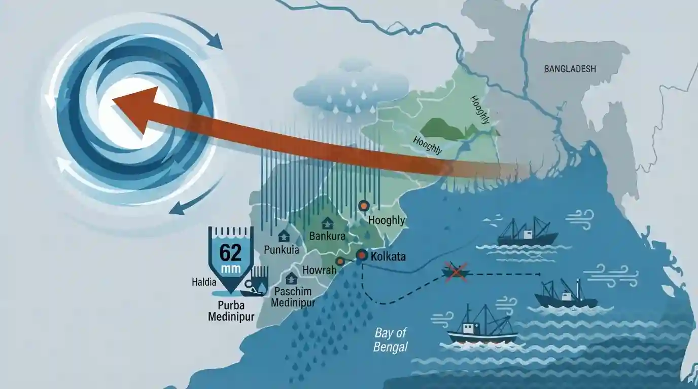
The India Meteorological Department (IMD) has issued a weather bulletin warning of heavy rainfall across the coastal and western districts of South Bengal due to a fresh low-pressure system over the northwest Bay of Bengal. Moving west-northwestward across north Odisha and Gangetic West Bengal, this system is bringing heavy precipitation to districts such as Purba and Paschim Medinipur, Howrah, Hooghly, Bankura, Purulia, and Kolkata. An advisory has been issued to fishermen warning of rough seas and squally winds, while coastal Haldia recorded the highest rainfall in the state at 62 mm.
Key Points
- A fresh low-pressure system has formed over the northwest Bay of Bengal and is expected to move in a west-northwestward direction across north Odisha and Gangetic West Bengal.
- Heavy rainfall is projected for several coastal, Gangetic, and western districts of South Bengal, including Kolkata, Howrah, Hooghly, North and South 24 Parganas, Purba and Paschim Medinipur, Jhargram, Bankura, and Purulia.
- The India Meteorological Department (IMD) issued an advisory for fishermen, urging them not to venture into the sea along the West Bengal and Odisha coasts and the north Bay of Bengal due to squally winds reaching 45 kmph.
- According to rainfall data, Haldia in the Purba Medinipur district recorded the highest rainfall in the state at 62 mm in the preceding 24 hours, followed by Darjeeling at 51 mm and Digha at 37 mm.
Important Terms
India Meteorological Department (IMD)

The national agency of India responsible for meteorological observations, weather forecasting, and seismology, crucial for tracking monsoons and issuing weather advisories.
UPSC context
WBCS Paper III (Geography); tests concepts related to climatology, monsoonal mechanisms, cyclones, and national meteorological services.
Press Trust of India (PTI)
India's largest premier news agency, operating as a non-profit cooperative of newspapers, providing critical national, international, and regional real-time news feeds.
UPSC context
WBCS Paper IV (GK & Current Affairs); tests prominent media institutions and sources of national news reporting.
Low-Pressure Area (LPA)
An atmospheric region where the pressure is lower than surrounding areas, causing air to rise, condense, and generate clouds and heavy precipitation like monsoon rain.
UPSC context
WBCS Paper III (Climatology); tests the formation of monsoonal depressions, rainfall variability, and tropical cyclones in the Bay of Bengal.
Gangetic West Bengal
A key meteorological and geographical sub-division of West Bengal south of the Ganges River, comprising fertile alluvial plains highly influenced by Bay of Bengal monsoons.
UPSC context
WBCS Paper III (Geography of West Bengal); tests physiographic divisions, climate, and regional agriculture of the southern plains.
Haldia
An important industrial city and major deep-water seaport located at the confluence of the Hooghly and Haldi rivers in Purba Medinipur, West Bengal.
UPSC context
WBCS Paper III (West Bengal Geography); tests major ports, industrial complexes, and economic regions of the state.
Prelims Trap
Monsoonal low-pressure depressions in the Bay of Bengal primarily travel in a north-eastward direction.
During the active monsoon phase, these depressions move west-northwestward across Odisha and Gangetic WB. North-eastward recurvature is typical of post-monsoon/pre-monsoon tropical cyclones.
Static Concepts Connected
How does rainfall vary across the distinct physical divisions of West Bengal?
- Northern Hill Region: Receives the highest precipitation (300-400 cm) due to the orographic lifting of the Bay of Bengal branch against the Himalayas.
- Gangetic Plains: Gets moderate rainfall (150-200 cm) driven primarily by transient low-pressure systems and depressions moving from the Bay of Bengal.
- Western Plateau Fringe: Comprising Purulia and western Bankura, it receives the lowest rainfall (100-125 cm), frequently experiencing semi-arid, drought-like conditions.
Cross-Topic Patterns
Monsoon depressions + Aman paddy cultivation
Late August low-pressure systems provide the crucial water volume required for transplanting Aman paddy in the moisture-deficient western districts like Purulia.
Coastal erosion + Haldia port logistics
Repeated squally weather and high-energy waves from northwest Bay depressions accelerate sand-dune retreat and siltation in the Hooghly estuary.

Expect questions matching West Bengal's district-wise rainfall variations with the movement of Bay of Bengal monsoon depressions.
Linked PYQs · 3
Linked PYQs · 3
- 2015WBCS_PRELIMSGS1
West Bengal gets most of its rainfall from
- 2011WBCS_PRELIMSGS1
Rainfall in West Bengal occurs due to summer monsoon by
- 2013WBCS_PRELIMSGS1
Cyclones of the Bay of Bengal are common during the
