New Glacial Lakes Form Near Nepal Border Following Ice Avalanche
Source:The Hindu ↗
हे का महत्त्वाचे आहे
This development highlights the growing vulnerability of the Himalayan ecosystem to climate-induced disasters like GLOFs and avalanches. For UPSC, it illustrates the critical transition from relying solely on technical early warning systems to adopting structural and regulatory changes like hazard zonation and construction restrictions in ecologically fragile river basins. It also emphasizes the importance of transboundary disaster management, as rivers originating in Tibet and Nepal flow directly into major Indian river basins.
सारांश
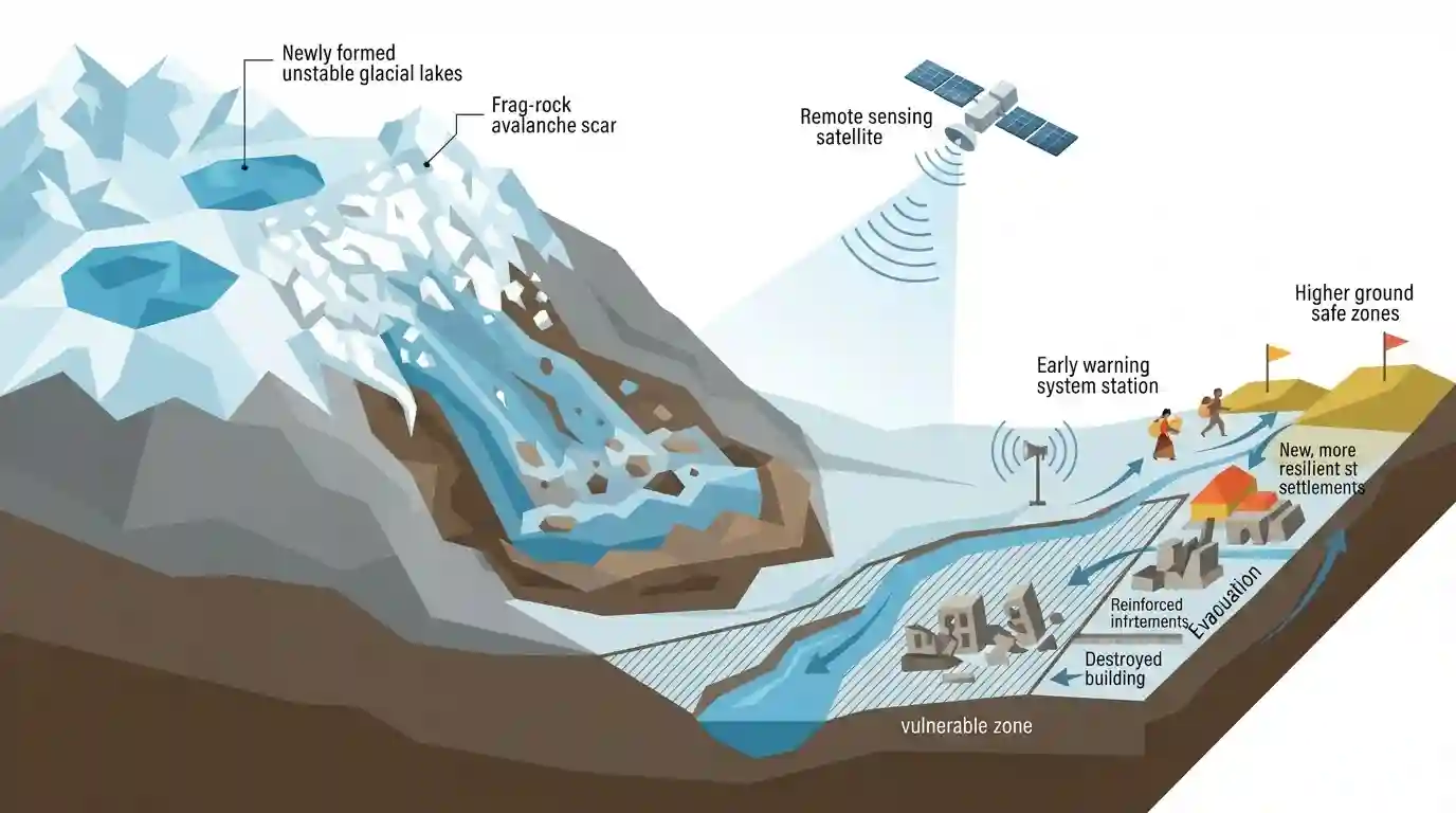
The article discusses the formation of two new glacial lakes near the Nepal-Tibet border at the source of a major ice-rock avalanche that triggered severe downstream flooding in the Bhote Koshi-Trishuli river system. While remote sensing technology helps identify these hazardous lakes, the National Disaster Management Authority (NDMA) emphasizes that early warning systems can only offer a short 30-45 minute evacuation window. Consequently, long-term disaster resilience requires robust land-use planning and restrictions on construction within vulnerable river basins to prevent catastrophic infrastructural losses.
मुख्य मुद्दे
- Two new glacial lakes, spanning approximately 19.80 hectares and 7.28 hectares, have formed in the high-altitude Lhende Khola region near the Nepal-Tibet border following a massive ice-rock avalanche on August 26, 2026.
- The avalanche was triggered when a massive block of glacier ice, rock, and debris detached from near Langtang Lirung at about 5,200 metres, falling approximately 1,200 metres into the Lhende Khola system to form a fast-moving debris flow that inundated the Bhote Koshi-Trishuli river system.
- While space-data analytics and high-resolution optical satellite imagery (such as that from Satellogic) help identify these newly formed water bodies, estimating the exact volume of accumulated water and predicting imminent outbursts remains challenging.
- The National Disaster Management Authority (NDMA) highlighted the inherent limitations of Early Warning Systems (EWS), which can provide a 30 to 45-minute advance warning to save lives but cannot prevent infrastructural devastation from billions of litres of gushing water.
- Effective disaster mitigation requires strict regulatory interventions, including hazard zonation, land-use planning, and restrictions on infrastructure development and construction in vulnerable river basins.
महत्त्वाच्या संज्ञा
National Disaster Management Authority (NDMA)

India's apex statutory body for disaster management, established under the Disaster Management Act, 2005, and chaired by the Prime Minister; responsible for laying down policies, plans, and guidelines to ensure effective disaster response.
UPSC context
GS Paper 3 (Disaster Management). Tests institutional disaster frameworks, national mitigation plans, and disaster response guidelines.
Glacial Lake Outburst Flood (GLOF)
A sudden, catastrophic release of water from a glacial lake caused by the failure of a natural dam (like ice or moraine), often triggered by avalanches, earthquakes, extreme rainfall, or rapid glacial melting.
UPSC context
GS Paper 3 (Disaster Management) & GS Paper 1 (Geography). Tests geophysical phenomena, climate change impacts, and Himalayan ecology.
Moraine Dam
A natural barrier formed by the accumulation of loose, unconsolidated glacial debris, rocks, and soil that impounds meltwater. Due to their structurally weak composition, they are highly susceptible to sudden breaches.
UPSC context
GS Paper 1 (Geomorphology) & GS Paper 3 (Disaster Management). Tests glacial landforms, structural vulnerabilities, and hazardous natural barriers.
Suhora Technologies
An Indian geospatial intelligence and space-data analytics firm that monitors climate risks and natural hazards, including Himalayan glacial lakes, utilizing high-resolution multi-sensor satellite imagery to support disaster mitigation.
UPSC context
GS Paper 3 (Science & Technology / Disaster Management). Tests private sector space innovations, remote sensing, and disaster monitoring.
Satellogic
A global leader in high-resolution, sub-meter Earth observation satellite imagery that partners with analytics firms to democratize real-time geospatial data for environmental tracking, disaster response, and climate change adaptation.
UPSC context
GS Paper 3 (Science & Technology). Tests international space collaborations, commercial satellite constellations, and geospatial data applications.
पूर्वपरीक्षा सापळा
The Trishuli-Narayani river system carrying transboundary GLOF discharges flows into the Kosi River before entering India.
Trishuli-Narayani is actually part of the Gandak river system, entering India (Bihar) as the Gandak River, not the Kosi River, despite the confusing 'Koshi' suffix.
संबंधित स्थिर संकल्पना
What is a GLOF and what causes its catastrophic release?
- Definition: Sudden, rapid release of impounded water from a glacial lake, often retained by unstable natural moraine dams.
- Primary Triggers: Rock or ice avalanches hitting the lake, heavy rainfall, displacement waves, or piping/erosion within the damming moraine.
- High Vulnerability: Himalayan glaciers are retreating rapidly due to climate change, creating numerous unstable proglacial lakes susceptible to sudden outbursts.
What are NDMA's primary strategies for GLOF mitigation?
- Structural Interventions: Reducing lake volume through controlled breaching, pumping out excess water, and constructing physical debris deflection walls downstream.
- Non-Structural Measures: Implementing multi-hazard zonation, enforcing strict land-use regulations to restrict floodplain construction, and deploying community-based early warning systems.
- Monitoring Protocol: Employs a two-step hazard assessment starting with remote sensing (SAR/optical satellites) followed by detailed in-situ geotechnical investigation.
आंतर-विषय नमुने
Transboundary GLOF governance and hydro-diplomacy
GLOF risks originating in Tibet/Nepal directly threaten downstream Indian plains, necessitating real-time transboundary data-sharing, joint risk monitoring, and coordinated disaster response protocols.
Himalayan hydropower vulnerability vs. GLOF risks
Run-of-the-river projects in ecologically fragile Himalayan basins face severe operational and financial risks from GLOFs, requiring climate-resilient engineering and stricter EIA mandates.

Expect questions linking transboundary Himalayan river paths (Gandak/Kosi) with NDMA's structural vs non-structural GLOF mitigation steps.
संबंधित PYQ · 2
संबंधित PYQ · 2
- 2019MainsGS3
Disaster preparedness is the first step in any disaster management process. Explain how hazard zonation mapping will help disaster mitigation in the case of landslides.
- 2021MainsGS3
Describe the various causes and the effects of landslides. Mention the important components of the National Landslide Risk Management Strategy.
