NCR Regional Plan 2041 Namo Cities and Pollution Zoning
Source:The Hindu ↗
Why It Matters
This article outlines the landmark structural changes in the NCR Regional Plan 2041. For UPPSC, understanding the spatial extent of the NCR, the role of counter-magnet areas in Uttar Pradesh (like Kanpur-Lucknow and Bareilly), and the environmental zoning strategies is highly relevant to physical, economic, and environmental geography as well as urban policy questions.
Summary
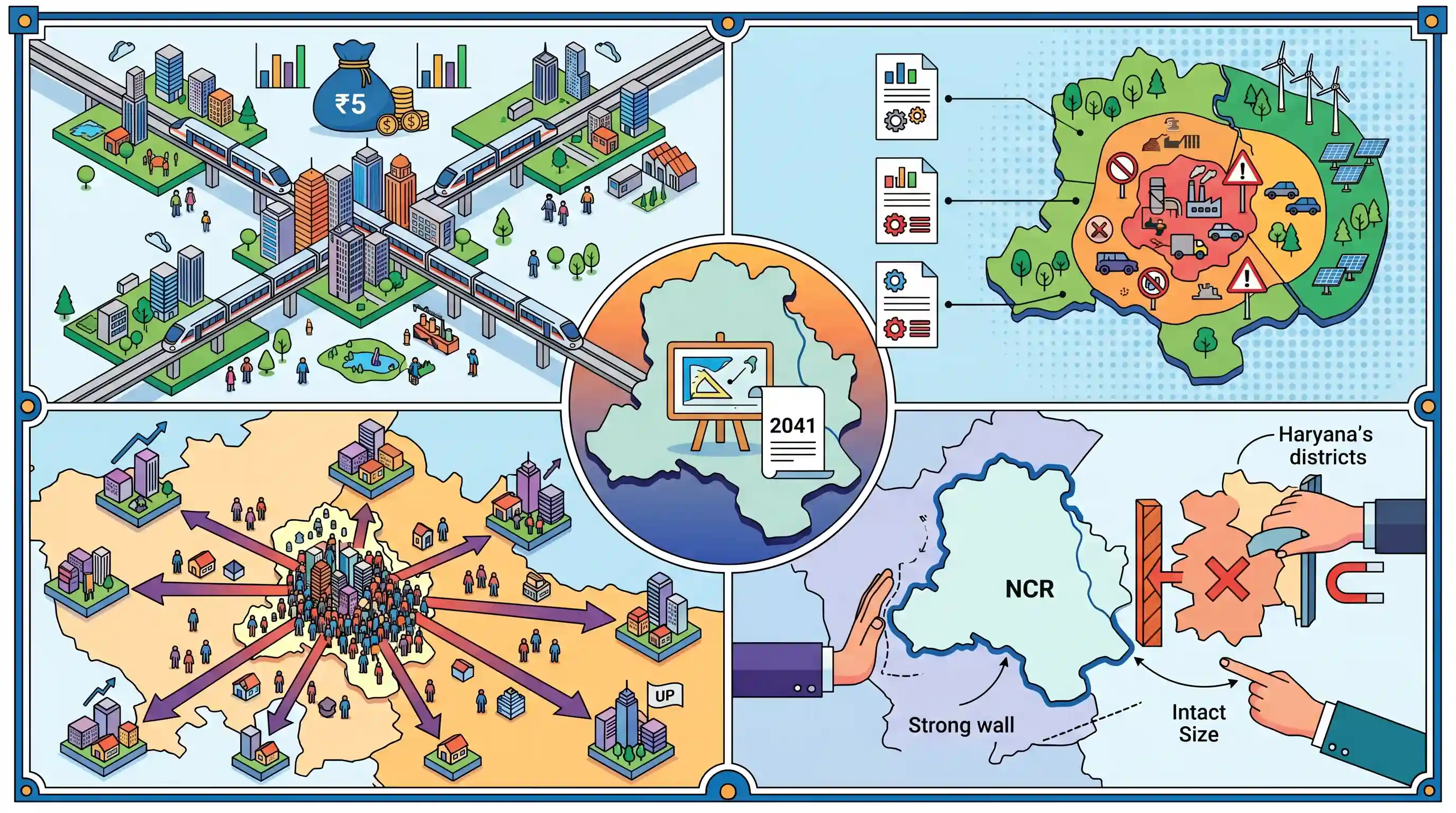
The National Capital Region Planning Board (NCRPB) has adopted the 'NCR Regional Plan 2041' blueprint. The key highlights include developing four transit-oriented 'Namo' cities along the RRTS corridors backed by a ₹5,000 crore incentive package, dividing the region into three pollution zones to apply tiered regulations, and confirming nine counter-magnet areas (such as UP's Kanpur-Lucknow and Bareilly) to redirect migration. The board kept the NCR's current size of 55,083 sq km intact by rejecting Haryana's request to add five more districts.
Key Points
- The NCR Planning Board (NCRPB), led by Union Minister Manohar Lal, finalized the 'NCR Regional Plan 2041' blueprint.
- Four 'Namo' Cities: The plan proposes one new transit-oriented development (TOD) 'Namo' city along the Regional Rapid Transit System (RRTS) corridor in each of the four constituent states/UT (Delhi, Haryana, Uttar Pradesh, and Rajasthan). These will be chosen via competitive bidding.
- Funding Pool: A performance-linked incentive pool of ₹5,000 crore (comprising grants, loans, and guarantees) has been earmarked by the NCR Planning Board to support these new cities.
- Three-Tier Pollution Zoning: To manage environmental degradation effectively, the NCR will be divided into three pollution zones. The innermost zone (Delhi and Central NCR) will face strict construction and industrial bans during peak winter smog, while distant peripheral districts will be exempted.
- Nine Counter-Magnet Areas (CMAs): Identified to reduce population and migration pressure on Delhi. These include Kanpur-Lucknow and Bareilly in Uttar Pradesh; Hisar and Ambala in Haryana; Kota and Jaipur in Rajasthan; Patiala-Rajpura in Punjab; Gwalior in Madhya Pradesh; and Dehradun in Uttarakhand.
- NCR Boundary Limits: The board maintained the current extent of 55,083 sq km (Delhi and 27 districts across Haryana, UP, and Rajasthan) and rejected Haryana's proposal to add Karnal, Jind, Panipat, Bhiwani, and Mahendragarh to the NCR.
Important Terms
NCR Regional Plan 2041

A multi-state strategic blueprint approved by the NCRPB to manage land use, housing, environmental restoration, and transit networks across the 55,083 sq km National Capital Region until 2041.
UPSC context
GS Paper III: Urbanization and infrastructure. Evaluates long-term regional development strategies and sustainable urban growth models.
NCR Planning Board (NCRPB)
A statutory body under the Ministry of Housing and Urban Affairs, constituted to coordinate, monitor, and prepare harmonized regional development plans for the National Capital Region.
UPSC context
GS Paper II: Statutory bodies. Examines inter-state institutional frameworks for regional governance and policy coordination.
National Capital Region Planning Board Act, 1985
The central legislation that established the NCRPB, mandated the creation of the NCR, and set the framework for sub-regional plans to prevent haphazard, uncoordinated urban development.
UPSC context
GS Paper II: Government policies. Focuses on legislative provisions enabling planned urban development and infrastructure control.
Namo Bharat Regional Rapid Transit System (RRTS)
India's first high-speed, rail-based commuter transit system designed to connect major nodes in the NCR, operating at speeds up to 180 km/h to promote regional mobility.
UPSC context
GS Paper III: Infrastructure and transport. Tests knowledge of fast, sustainable transit models and regional economic integration.
Counter-Magnet Areas (CMAs)
Designated urban centers or corridors located outside a metropolitan region's core, developed with robust infrastructure and economic opportunities to intercept the flow of rural-urban migration.
UPSC context
GS Paper I/III: Urbanization and migration. Tests methods to decentralize urban growth and manage population pressures.
Transit-Oriented Development (TOD)
An urban planning approach that concentrates housing, offices, retail, and public services within walking distance of high-capacity transit nodes like metro or RRTS stations.
UPSC context
GS Paper III: Urban planning. Examines sustainable land-use patterns that align public transit with dense housing.
Ministry of Housing and Urban Affairs (MoHUA)
The nodal ministry of the Government of India responsible for formulating policies, administering schemes, and coordinating programs related to urban housing, municipal development, and regional spatial planning.
UPSC context
GS Paper II: Government ministries. Examines central urban initiatives, governance frameworks, and housing policies.
Prelims Trap
All designated Counter-Magnet Areas (CMAs) must be located within the territory of the four constituent NCR states.
CMAs like Gwalior (MP), Patiala (Punjab), and Dehradun (Uttarakhand) lie outside the NCR and include states that do not share physical boundaries with the NCR itself.
Static Concepts Connected
What is the statutory framework and role of the NCR Planning Board (NCRPB)?
- Statutory Basis: Constituted under the NCRPB Act, 1985, under the Ministry of Housing and Urban Affairs (MoHUA) to guide regional development.
- Composition: Chaired by the Union Minister of Housing and Urban Affairs, with members including Chief Ministers of participating states.
- Key Mandate: Prepares binding Regional Plans and funds infrastructure to harmonize development across Delhi, Haryana, Uttar Pradesh, and Rajasthan.
What are Counter-Magnet Areas (CMAs) in regional development?
- Definition: Urban centers located far outside the Delhi metropolitan area designated to act as alternative growth poles.
- Primary Objective: To intercept and absorb potential migratory flows heading towards the national capital by offering comparable economic opportunities.
- Geographic Scope: Includes cities in non-NCR states like Gwalior (MP), Patiala (Punjab), and Dehradun (Uttarakhand) to spread regional growth.
Cross-Topic Patterns
Fiscal federalism in urban planning
The use of competitive bidding and performance-linked incentive pools (₹5,000 crore) represents a shift from direct administrative allocations to competitive cooperative federalism in regional planning.
Differentiated environmental regulations
Dividing NCR into three distinct pollution zones departs from blanket bans, acknowledging that economic resilience in peripheral regions requires tailored environmental regulations.

The distinction between NCR boundaries and Counter-Magnet Areas in non-NCR states is likely to be tested in a multi-statement Prelims question.
Linked PYQs · 3
Linked PYQs · 3
- 2022UPPSC_PRELIMSGS1
By which amendment of the Constitution, 'Delhi' has been made National Capital Region?
- 2021UPPSC_PRELIMSGS1
Which one of the following is known as acceleration stage in the urbanization curve ?
- 2018UPPSC_PRELIMSGS1
Which of the following cities in Uttar Pradesh has NOT been selected for development under the Smart City Development Programme of the Central Government?
