Flash Floods and Disaster Management in Jammu and Kashmir
Source:The Hindu ↗
આ શા માટે મહત્વનું છે
This event serves as a contemporary case study for GS3 Disaster Management and Environment, illustrating the devastating impact of extreme weather anomalies on fragile mountain ecosystems and the vital role of coordinated institutional response (SDRF, Army). It also holds relevance for GS1 Geography regarding Himalayan river systems.
સારાંશ
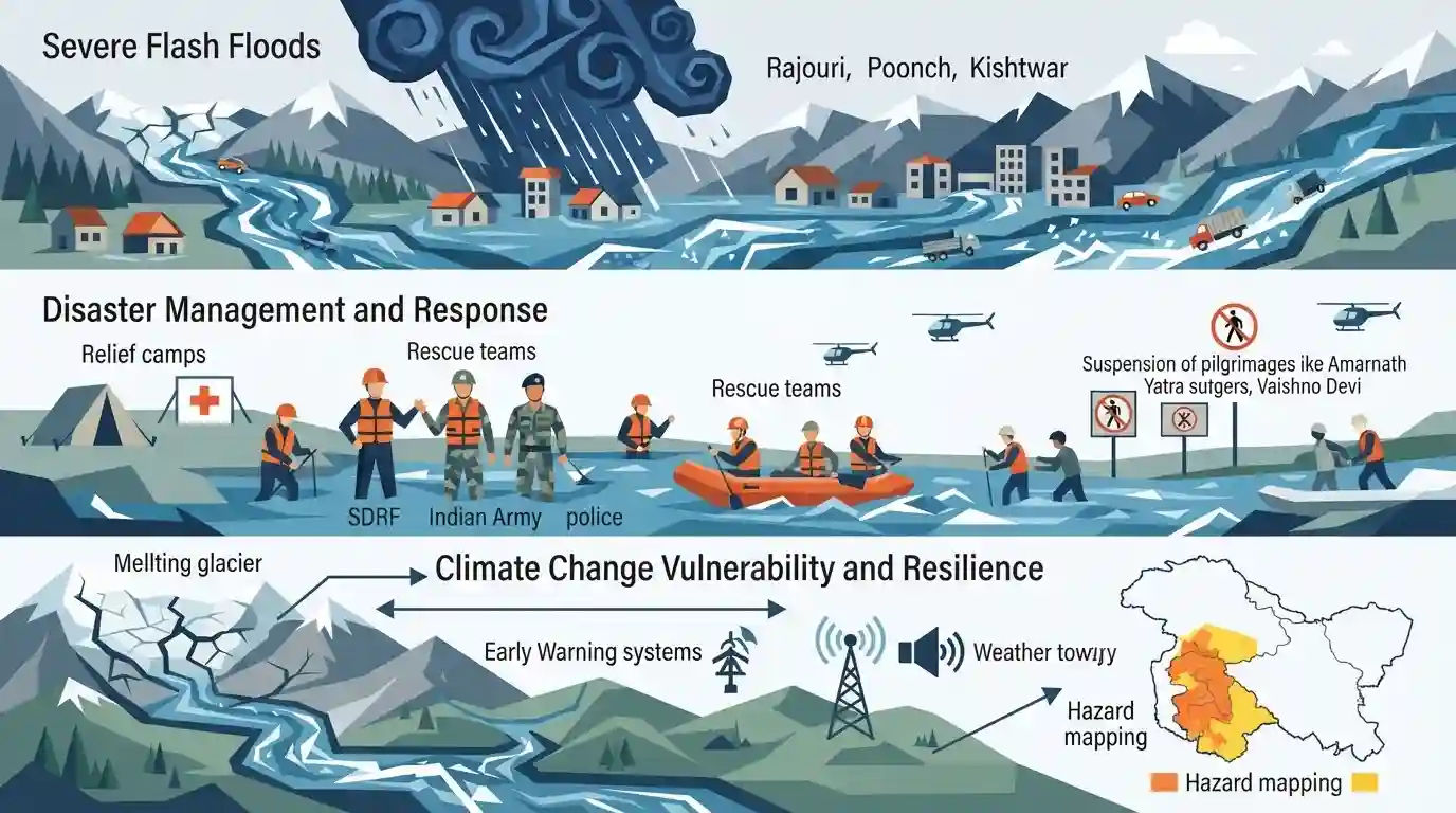
Severe flash floods triggered by intense rainfall have wreaked havoc across Jammu and Kashmir, particularly in the Rajouri, Poonch, and Kishtwar districts. The sudden swelling of local rivers, including the Darhali and Khandli, resulted in extensive damage to property, the washing away of vehicles, and at least 10 feared casualties. In response to the extreme weather forecasts by the IMD, major pilgrimages like the Amarnath Yatra and Vaishno Devi have been suspended. Relief and rescue operations are actively underway, driven by a coordinated effort between the SDRF, the Indian Army, and local police. The recurring nature of such extreme weather events underscores the acute vulnerability of the Himalayan region to climate change, bringing to the forefront the critical need for disaster resilience frameworks, hazard mapping, and effective early warning systems in hilly terrains.
મુખ્ય મુદ્દા
- Heavy rainfall triggered massive flash floods in J&K, severely affecting Rajouri, Poonch, and Kishtwar, leaving at least 10 people feared dead and causing widespread structural damage.
- Sudden surges in water levels were recorded in local rivers across the Pir Panjal range, including the Darhali, Khandli, Suktoh, and Jamola.
- Major religious pilgrimages, including the Amarnath Yatra, Vaishno Devi, and Shiv Khori, were suspended due to adverse weather and damaged tracks.
- Coordinated rescue operations were launched by the SDRF, Indian Army, J&K Police, and civil administration.
- The incident highlights the heightened vulnerability of the fragile Himalayan ecosystem to extreme weather events and emphasizes the need for climate resilience and robust early warning systems.
મહત્વપૂર્ણ શબ્દો
State Disaster Response Force (SDRF)

A specialized state-level force in India established to handle emergency response, search, and rescue operations during natural or man-made disasters, working in close coordination with the central National Disaster Response Force (NDRF).
UPSC context
Relevant for GS Paper III (Disaster Management); tests knowledge of institutional frameworks for disaster response and state-level governance.
India Meteorological Department (IMD)
India’s principal government agency under the Ministry of Earth Sciences responsible for meteorological observations, weather forecasting, and issuing early warnings for natural hazards like cyclones and heavy monsoon rainfall.
UPSC context
Relevant for GS Paper I (Geography) and GS Paper III (Disaster Management); tests knowledge of weather forecasting systems and early warning mechanisms.
Flash Floods
Rapid, high-volume floods occurring within six hours of heavy rainfall, cloudbursts, or dam failures, characterized by swift water flows and minimal warning time, particularly common in hilly or mountain terrains.
UPSC context
Relevant for GS Paper I (Geographical Phenomena) and GS Paper III (Disaster Management); tests mitigation strategies and regional climate vulnerability.
Himalayan Ecosystem
An ecologically fragile and geologically young mountain region in northern India that acts as a monsoon barrier, regulates climate, and is highly vulnerable to seismic activity, landslides, and climate-induced disasters.
UPSC context
Relevant for GS Paper I (Geography) and GS Paper III (Environment); tests understanding of ecological conservation and mountain biome fragility.
પ્રિલિમ્સ ટ્રેપ
Floodplain zoning and hazard mapping are classified as structural mitigation measures under India's national guidelines.
NDMA classifies zoning, hazard mapping, and early warning systems as non-structural. Aspirants often mistake these policy-level and planning regulatory interventions for physical, structural engineering works.
સંલગ્ન સ્થિર ખ્યાલો
What is the distinction between Structural and Non-Structural flood mitigation under NDMA?
- Structural Measures: Physical constructions such as embankments, flood walls, channel improvements, and detention basins to physically contain or redirect floodwaters.
- Non-Structural Measures: Planning, regulatory, and policy actions like Floodplain Zoning, hazard mapping, early warning systems, and raising community awareness to reduce vulnerability.
- Floodplain Zoning: A non-structural tool to regulate developmental activities in floodplains, restricting high-value infrastructure in high-probability flood zones.
What is Target G of the Sendai Framework for Disaster Risk Reduction (2015-2030)?
- Core Objective: Aims to substantially increase availability of and access to multi-hazard early warning systems (MHEWS) and disaster risk information.
- Global Timeline: It is one of the 7 global targets set to reduce disaster mortality, economic loss, and critical infrastructure damage globally by 2030.
- Indian Application: Directly guides India's deployment of Doppler Weather Radars and localized landslide warning networks in the vulnerable Himalayan states.
આંતર-વિષય પેટર્ન
Pilgrim Tourism vs. Carrying Capacity
Unregulated religious tourism (e.g., Amarnath, Vaishno Devi) clashes with the fragile Himalayan terrain's carrying capacity, exacerbating disaster vulnerability.
Space Tech + Disaster Resilience
Using ISRO’s satellite-derived landslide zonation maps alongside IMD’s Doppler Radars highlights the vital role of space technology in meeting climate adaptation goals.

UPSC 2026 is highly likely to contrast structural vs non-structural flood mitigation, mapping them directly to Sendai Target G.
સંલગ્ન PYQ · 4
સંલગ્ન PYQ · 4
- 2024MainsGS3
Flooding in urban areas is an emerging climate-induced disaster. Discuss the causes of this disaster. Mention the features of two such major floods in the last two decades in India. Describe the policies and frameworks in India that aim at tackling such floods.
- 2024MainsGS3
What is disaster resilience? How is it determined? Describe various elements of a resilience framework. Also mention the global targets of Sendai Framework for Disaster Risk Reduction (2015–2030).
- 2021MainsGS3
Describe the various causes and the effects of landslides. Mention the important components of the National Landslide Risk Management Strategy.
- 2023PrelimsGS1
Consider the following statements: 1. Jhelum River passes through Wular Lake. 2. Krishna River directly feeds Kolleru Lake. 3. Meandering of Gandak River formed Kanwar Lake. How many of the statements given above are correct?
