Ramganga River Blocked by Landslide Creating Flash Flood Risk
Source:etvbharat ↗
Why It Matters
Understanding the difference between Eastern and Western Ramganga rivers, the nature of landslide-dammed lakes (LLOFs) as recurring Himalayan hazards, and local geography is highly critical for UKPSC PCS Prelims physical geography and disaster management questions.
Summary
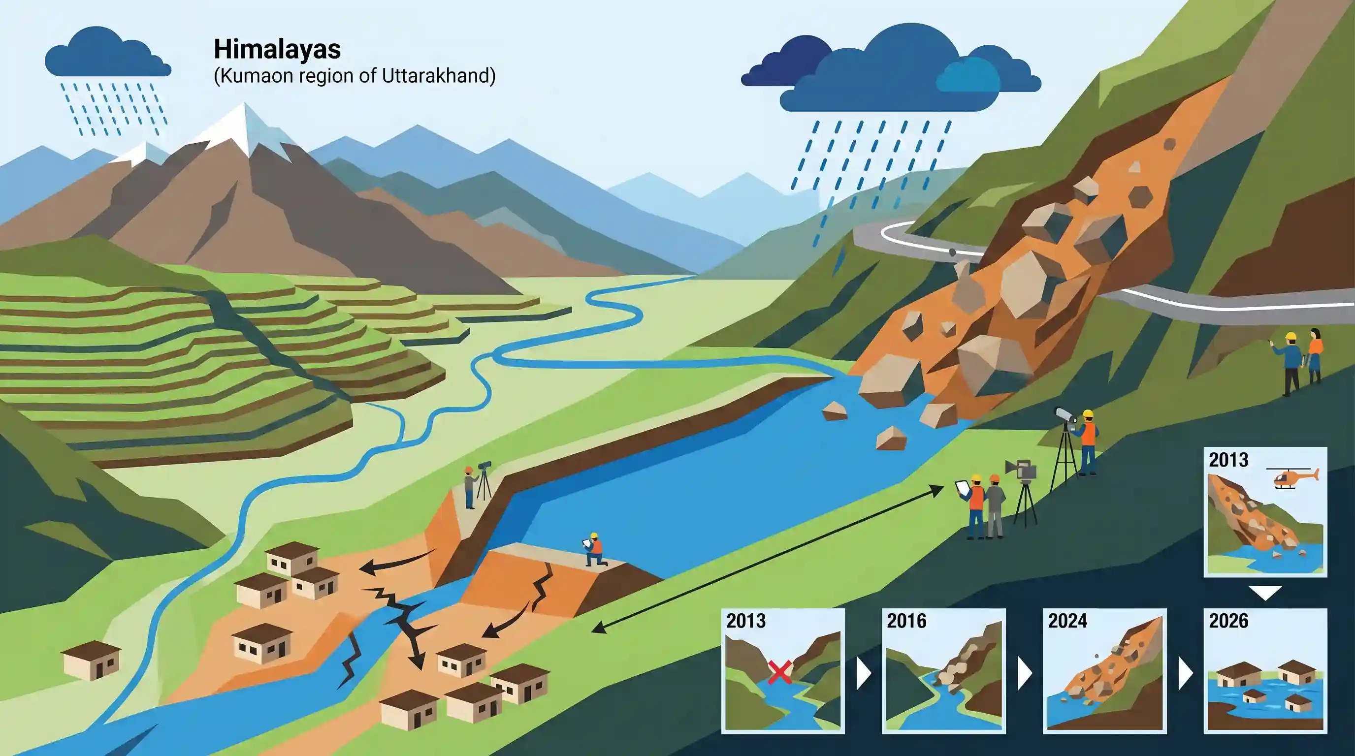
In July 2026, continuous heavy rainfall in Uttarakhand's Pithoragarh district triggered a major landslide near Haradiya on the Thal-Munsiyari motor road, blocking the Eastern Ramganga River. This block led to the formation of an artificial landslide-dammed lake extending approximately 600–800 meters, threatening downstream villages (Bhaiskhal, Basgun, Chhipa, and Bhaiskot) and raising fears of Landslide Lake Outburst Floods (LLOFs). The district administration and irrigation department are monitoring the situation and planning safe drainage measures, noting that similar hazard events occurred in the same river basin in 2013, 2016, and 2024.
Key Points
- A major landslide near Haradiya on the Thal-Munsiyari motor road in Pithoragarh district blocked the flow of the Ramganga River, leading to the formation of an artificial landslide-dammed lake about 600 to 800 meters in size.
- The blocked river is the Eastern Ramganga, which originates at the Namik Glacier in Pithoragarh and merges with the Sarju River at Rameshwar (unlike the Western Ramganga, which originates in the Dudhatoli range).
- The rising lake water threatens several local villages (Bhaiskhal, Basgun, Chhipa, and Bhaiskot), endangering a population of 600 to 700 people.
- The accumulation of debris and consequent lake formation in the Ramganga River has been a recurring hazard in the region, with previous notable occurrences in 2013, 2016, and 2024.
- The primary hazard associated with such landslide-dammed lakes in the Himalayas is Landslide Lake Outburst Floods (LLOFs), which can trigger sudden and devastating flash floods downstream if the debris barrier breaches.
- The local administration and Irrigation Department are currently assessing safe drainage routes and exploring the channelisation of the Haradiya Nala to prevent a catastrophic breach.
Important Terms
Landslide Lake Outburst Flood (LLOF)

A sudden, catastrophic flood triggered when a natural dam created by a landslide blocks a river, forms an impounded lake, and subsequently breaches due to erosion, structural instability, or water pressure.
UPSC context
GS Paper 3 (Disaster Management); tests knowledge of geological hazards, mountain risk mitigation, and climate-induced disaster cascades in the Himalayas.
Eastern Ramganga River
A major Himalayan river originating from the Namik Glacier in Uttarakhand's Kumaon region, flowing through Pithoragarh district, and distinct from the Western Ramganga River which originates in Pauri Garhwal.
UPSC context
GS Paper 1 (Geography); tests geographic identification of Himalayan drainage systems, river basins, and regional physiographic features.
Kumaon Himalayas
The west-central section of the Himalayas in Uttarakhand, extending from the Sutlej River in the west to the Kali River in the east, characterized by ecologically fragile, seismic-prone ranges.
UPSC context
GS Paper 1 (Physical Geography of India); tests regional classifications of the Himalayas, major peaks, drainage networks, and tectonic vulnerabilities.
Glacial Lake Outburst Flood (GLOF)
A high-velocity flood occurring when a moraine- or ice-dammed glacial lake suddenly releases massive volumes of meltwater due to dam failure, often triggered by rapid warming, earthquakes, or avalanches.
UPSC context
GS Paper 3 (Disaster Management); tests comprehension of climate change impacts on glaciers, hazard vulnerability mapping, and early warning systems.
District Administration
The chief administrative unit of a state government responsible for maintaining law and order, implementing development policies, and coordinating disaster response at the local level.
UPSC context
GS Paper 2 (Governance); tests understanding of decentralized executive roles, local crisis management, and institutional disaster response frameworks.
State Irrigation Department
A government department responsible for planning, executing, and maintaining irrigation networks, water resource management, and flood control measures, including reservoir safety and channelization.
UPSC context
GS Paper 3 (Infrastructure); tests understanding of water governance, flood mitigation infrastructure, and inter-departmental crisis response.
Prelims Trap
The Eastern Ramganga River originates in the Dudhatoli range and flows through the Jim Corbett National Park before joining the Ganga.
Aspirants confuse Eastern and Western Ramganga. The Eastern Ramganga originates at Namik Glacier and joins the Sarju, whereas the Western Ramganga originates at Dudhatoli and flows through Corbett.
Static Concepts Connected
What distinguishes the Eastern and Western Ramganga river systems?
- Origin sites: Eastern Ramganga originates from Namik Glacier in Pithoragarh, while Western Ramganga originates in the Dudhatoli mountain range across Chamoli and Almora.
- Confluence points: Eastern Ramganga joins the Sarju River at Rameshwar, whereas Western Ramganga joins the Ganga River near Kannauj in Uttar Pradesh.
- Ecological paths: Western Ramganga flows through the Corbett National Park, while Eastern Ramganga drains the rugged, high-altitude Kumaon Himalayas.
How do LLOFs differ from GLOFs in mountain hazard profiles?
- Dam composition: LLOFs result from landslides blocking river channels with unconsolidated soil and rock, while GLOFs occur from failures of ice or moraine-dammed glacial lakes.
- Location and altitude: GLOFs are restricted to high-altitude proglacial areas, whereas LLOFs can occur further downstream in steep, narrow valleys during heavy monsoon rainfall.
Cross-Topic Patterns
Infrastructure-induced landslide risks
Linear infrastructure development like the Thal-Munsiyari road in fragile Himalayan terrains alters slope hydrology, accelerating landslide frequency and triggering downstream LLOFs.
Transboundary water management
Saryu-Kali river dynamics feed into the Mahakali treaty basin; headwater hazards like LLOFs directly affect downstream bilateral hydro projects like the Pancheshwar Multipurpose Project.

Distinctions between Eastern and Western Ramganga basins paired with LLOF-GLOF definitions are highly probable for GS Prelims 2026.
Linked PYQs · 3
Linked PYQs · 3
- 2024UKPSC_PRELIMSGS1
Select the correct pair of the river basins separated by Dudhatoli Mt. Range.
- 2025UKPSC_PRELIMSGS1
Which of the following is the correct order of rivers from west to east in Uttarakhand?
- 2024UKPSC_PRELIMSGS1
'Untadhura Pass' is situated near which one of the following glaciers of Uttarakhand ?
