Scientific Teams to Inspect Vulnerable Glacial Lakes in Uttarakhand
Source:etv-bharat ↗
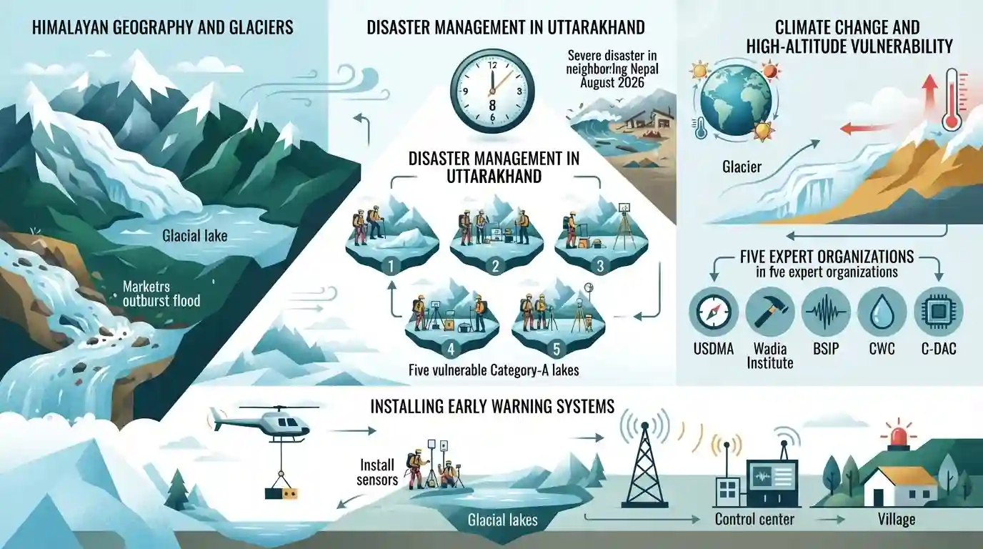
Why It Matters
GLOFs represent one of the most critical climate-induced natural hazards in the Himalayan region. Understanding the specific geographic locations (districts and names) of vulnerable glacial lakes (like Vasudhara, Kedartal, and Saraswati Tal) and the institutional framework involved in disaster risk reduction is highly relevant for UKPSC PCS Prelims questions.
Summary
Following a severe disaster in neighboring Nepal in August 2026, scientific teams in Uttarakhand are fast-tracking ground studies of five highly vulnerable (Category-A) glacial lakes starting September 8, 2026. The state has identified 13 highly sensitive glacial lakes out of approximately 450. Experts from USDMA, Wadia Institute, BSIP, CWC, and C-DAC will study GLOF risks and look into installing early warning systems funded by an NDMA special package, despite the harsh high-altitude challenges.
Key Points
- Scientific Expedition: Beginning September 8, 2026, multi-institutional expert teams will conduct ground-zero field studies of 5 highly sensitive (Category-A) glacial lakes in Uttarakhand to assess Glacial Lake Outburst Flood (GLOF) risks.
- Glacial Lakes Inventory: Uttarakhand has approximately 450 glacial lakes, of which 13 have been identified as highly sensitive and placed under Category A.
- Classification of Sensitive Lakes: Category A (highly vulnerable) includes Vasudhara Lake (Chamoli), Mambag Lake (Dharchula, Pithoragarh), Syuntiankitta Lake (Dharchula, Pithoragarh), Pyungru Lake (Dharchula, Pithoragarh), and an unnamed lake in Joshimath (Chamoli). Category B includes Saraswati Tal (Chamoli) and Kedartal (Uttarkashi), while Category C features lakes in Tehri, Pithoragarh, and Bageshwar.
- Disaster Context: The urgency of this study has been heightened following a severe glacial/flash flood disaster in Nepal on August 26, 2026. GLOFs occur when natural moraine dams breach, releasing massive volumes of debris, boulders, and water at high speeds.
- Mitigation & Early Warning: The NDMA has provided a special financial package to install state-of-the-art monitoring and early warning systems at these lakes. However, freezing temperatures and high-altitude logistics remain significant operational hurdles.
Important Terms
National Disaster Management Authority (NDMA)

The apex national statutory body for disaster management, established under the Disaster Management Act, 2005, and headed by the Prime Minister, responsible for policymaking and coordinating disaster mitigation across India.
UPSC context
GS Paper-IV (Disaster Management); tests national-level institutional mechanisms, safety frameworks, and early warning initiatives.
Uttarakhand State Disaster Management Authority (USDMA)
The nodal state government agency in Uttarakhand, established under the Disaster Management Act, 2005, responsible for planning, coordinating, and implementing disaster prevention, preparedness, and response activities.
UPSC context
GS Paper-IV (Uttarakhand Geography & Disaster Management); tests regional hazard response and localized vulnerability reduction schemes.
Wadia Institute of Himalayan Geology (WIHG)
An autonomous research institute under the Department of Science and Technology, based in Dehradun, specializing in geodynamics, seismology, glaciology, and environmental geology of the Himalayas.
UPSC context
GS Paper-IV (Himalayan Geography); tests technical research, glacial monitoring, and mountain hazard assessments.
Birbal Sahni Institute of Palaeosciences (BSIP)
An autonomous scientific institute under the Department of Science and Technology, located in Lucknow, dedicated to understanding fossil plants, ancient ecosystems, past climates, and geological history.
UPSC context
GS Paper-IV (Environment & Paleoclimate); tests specialized research on historical climatic shifts and high-altitude lake sedimentology.
Central Water Commission (CWC)
A premier technical organization of India operating under the Ministry of Jal Shakti, charged with flood forecasting, reservoir monitoring, and coordinating river valley development projects.
UPSC context
GS Paper-IV (Water Resources & Hydrology); tests flood control systems, river hydrology, and trans-boundary river monitoring.
Centre for Development of Advanced Computing (C-DAC)
The premier R&D organization under the Ministry of Electronics and Information Technology, focused on advanced software systems, supercomputing, and technical applications for real-time risk assessment.
UPSC context
GS Paper-V (Science & Technology); tests supercomputing applications and tech-driven disaster management communication channels.
Prelims Trap
Chamoli district has the maximum number of highly sensitive (Category A/B/C) glacial lakes among Uttarakhand districts.
Pithoragarh actually has the highest share (6 lakes) of the 13 sensitive lakes, while Chamoli has 4, and Uttarkashi, Tehri, and Bageshwar have 1 each.
Static Concepts Connected
What is a GLOF and its primary triggers?
- Definition: Sudden, catastrophic release of water from moraine-dammed or ice-dammed lakes formed by retreating glaciers.
- Moraine Failure: Unconsolidated glacial debris (moraines) serving as natural dams fail under intense hydrostatic pressure or structural erosion.
- Trigger Elements: High-altitude heavy rainfall, ice-avalanches, or earthquakes destabilize the moraine barrier, causing sudden breaches.
What is the Wadia Institute of Himalayan Geology (WIHG)?
- Origins: Established in 1968 at Delhi University; relocated to its permanent headquarters in Dehradun, Uttarakhand, in 1976.
- Status: Autonomous research institution functioning under the Department of Science and Technology (DST), Government of India.
- Core Mandate: Conducts advanced research in Himalayan geodynamics, seismology, landslide hazards, and glacier-lake dynamics.
Cross-Topic Patterns
GLOFs & run-of-the-river hydropower
Proximity of sensitive lakes like Vasudhara to Dhauliganga exposes downstream run-of-the-river power plants to sudden structural destruction, disrupting state energy grids.
Telemetry & high-altitude disaster management
Integrating C-DAC's satellite telemetry with USDMA alert systems showcases how high-altitude communications overcome extreme terrain constraints to enable real-time hazard mitigation.

Match-the-following questions pairing sensitive glacial lakes (e.g., Mambag, Vasudhara) to their districts are highly probable.
Linked PYQs · 3
Linked PYQs · 3
- 2025UKPSC_PRELIMSGS1
Consider the following statements and select the correct answer from the options given below : Statement 1 : Uttarakhand is highly vulnerable to climate change. Statement 2 : Climate change is causing water stress and depleting biodiversity in Uttarakhand.
- 2024UKPSC_PRELIMSGS1
'Untadhura Pass' is situated near which one of the following glaciers of Uttarakhand ?
- 2025UKPSC_PRELIMSGS1
Which of the following is the correct order of rivers from west to east in Uttarakhand?
