Meteorological Drivers and Thermal Remote Sensing of Summer Heatwaves
Source:Indian Express ↗
Why It Matters
Heatwaves are increasingly recognized as severe meteorological disasters. This article integrates static geographical concepts (El Niño, Western Disturbances, UHI) with dynamic technological applications (satellite remote sensing) and disaster vulnerability. It directly addresses the GS1 syllabus on climatic phenomena and urbanization, as well as GS3 components on disaster management and technology, making it highly relevant for Mains answers on climate adaptation.
Summary
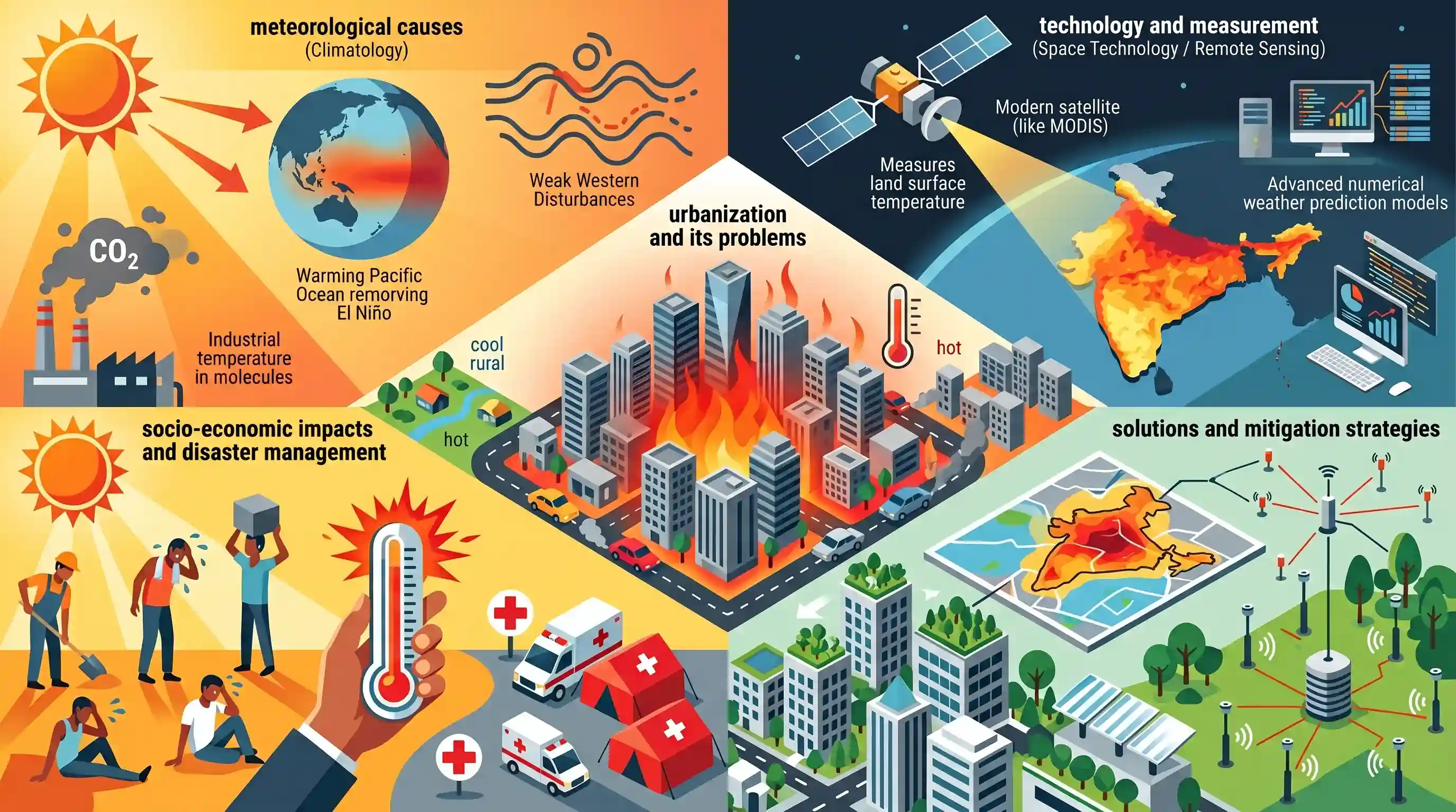
The article provides a comprehensive analysis of the intensifying summer heatwaves in India, exploring their meteorological causes, the technology used to measure them, and the socio-economic impacts. It explains that extreme temperatures are driven by a combination of global phenomena like El Niño, long-term climate change, and localized drivers such as weak western disturbances and the Urban Heat Island (UHI) effect. To track these anomalies, agencies use advanced numerical weather prediction models and thermal remote sensing satellites (like MODIS), which measure land surface temperature. The article emphasizes that heatwaves act as a severe disaster, disproportionately affecting vulnerable groups like informal outdoor workers. To mitigate these impacts, it advocates for leveraging geospatial data to map urban heat zones and implementing targeted cooling strategies alongside denser ground-station networks.
Key Points
- The intensifying heat in India is a cumulative result of global factors like El Niño and anthropogenic climate change, alongside local factors such as weak western disturbances and the Urban Heat Island (UHI) effect.
- Heat monitoring relies on thermal remote sensing satellites (like MODIS and Landsat) and Numerical Weather Prediction (NWP) models to generate high-resolution thermal maps.
- Satellites capture land surface skin temperature, which is essential for spatial mapping, though it differs from the atmospheric air temperature felt by humans.
- Extreme heat disproportionately impacts vulnerable populations, particularly informal outdoor workers, the elderly, and infants, leading to severe health and economic consequences.
- Effective mitigation requires utilizing geospatial technologies to map UHIs and implement targeted local interventions, along with expanding the network of ground-based weather stations.
Important Terms
India Meteorological Department (IMD)

The nodal agency under the Ministry of Earth Sciences responsible for meteorological observations, weather forecasting, and seismology. It sets temperature thresholds to officially declare heatwaves and severe heatwaves across India.
UPSC context
GS-1 (Geography) and GS-3 (Disaster Management); essential for understanding institutional frameworks for climate monitoring and disaster early warning systems.
Urban Heat Island (UHI) Effect
A phenomenon where urban areas experience significantly higher temperatures than surrounding rural areas due to heat-trapping surfaces like concrete, lack of vegetation, and anthropogenic waste heat.
UPSC context
GS-1 (Urbanization) and GS-3 (Environment); tests knowledge of anthropogenic climate impacts and sustainable urban planning strategies.
Western Disturbances
Extra-tropical cyclones originating in the Mediterranean region that bring non-monsoonal rainfall to northwest India. Their absence or weakness during summer allows intense heat build-up over the subcontinent.
UPSC context
GS-1 (Physical Geography); critical for explaining seasonal weather variations, Rabi crop success, and modern heatwave intensity in India.
Global Forecast System (GFS)
A global numerical weather prediction system run by the US National Weather Service. It provides long-range weather data that helps Indian agencies model and predict heatwave trends.
UPSC context
GS-3 (Science & Tech); relevant for understanding the technological infrastructure and international cooperation behind meteorological modeling.
Heat Action Plan (HAP)
Comprehensive strategies at city or state levels to increase preparedness and reduce health risks during extreme heat. They include early warnings, public awareness, and inter-agency coordination.
UPSC context
GS-3 (Disaster Management); tests knowledge of policy-level mitigation and adaptation strategies against climate-induced disasters.
Moderate Resolution Imaging Spectroradiometer (MODIS)
A satellite-based sensor that measures land surface temperature and vegetation health. It provides critical geospatial data for mapping urban heat zones and monitoring anomalies in real-time.
UPSC context
GS-3 (Space Technology/Remote Sensing); highlights the role of satellite data in precision disaster management and environmental monitoring.
El Niño
A climate pattern involving the warming of surface waters in the eastern Pacific Ocean. It often correlates with suppressed rainfall and intensified summer heatwaves in the Indian subcontinent.
UPSC context
GS-1 (Climatology); a core concept for analyzing global climate drivers and their specific impacts on the Indian Monsoon.
Prelims Trap
Satellites like MODIS directly measure atmospheric air temperature to declare heatwaves.
Satellites measure Land Surface Skin Temperature (LST), which is radiometric. IMD relies on ground stations to measure kinetic air temperature for official heatwave declarations.
Static Concepts Connected
What are the IMD criteria for declaring a heatwave?
- Threshold Temperatures: Maximum temperature must reach at least 40°C for plains, 37°C for coastal areas, and 30°C for hilly regions.
- Departure from Normal: A heatwave is declared if the temperature departure from normal is 4.5°C to 6.4°C (Severe if >6.4°C).
- Absolute Temperature: A severe heatwave is automatically declared if the absolute maximum temperature hits 47°C, regardless of the normal temperature.
What drives the Urban Heat Island (UHI) effect?
- Low Albedo: Concrete and asphalt absorb and retain more solar radiation than natural vegetation, which cools via evapotranspiration.
- Urban Canopy Effect: Tall buildings create an 'urban canyon effect' that traps long-wave radiation and blocks cooling wind speeds.
- Anthropogenic Heat: Waste heat emissions from vehicles, industrial plants, and air conditioning units continuously add to localized heat accumulation.
Cross-Topic Patterns
Heat stress & informal economy
Heatwaves bridge Climatology and Economy, as extreme temperatures disproportionately slash labor productivity in agriculture and construction, heavily impacting India's informal sector GDP.
Space Tech for Urban Planning
Thermal remote sensing (MODIS) is increasingly tested not just as pure S&T, but as a crucial governance tool for designing micro-level NDMA Heat Action Plans.

A 2026 Prelims statement-based question will likely test the technical distinction between satellite-derived LST and IMD air temperature.
Linked PYQs · 4
Linked PYQs · 4
- 2013MainsGS1
Bring out the causes for the formation of heat islands in the urban habitat of the world.
- 2014MainsGS1
Most of the unusual climatic happenings are explained as an outcome of the El-Nino effect. Do you agree?
- 2019PrelimsGS1
For the measurement/estimation of which of the following are satellite images/remote sensing data used? 1. Chlorophyll content in the vegetation of a specific location 2. Greenhouse gas emissions from rice paddies of a specific location 3. Land surface temperatures of a specific location Select the correct answer using the code given below.
- 2019MainsGS3
Vulnerability is an essential element for defining disaster impacts and its threat to people. How and in what ways can vulnerability to disasters be characterized? Discuss different types of vulnerability with reference to disasters.
