El Nino kharif season water management and irrigation strategies
Source:thehansindia ↗
ఇది ఎందుకు ముఖ్యం
This article illustrates practical climate adaptation and disaster mitigation strategies at the state level. It directly connects macro-geographical phenomena like El Niño to regional agricultural planning, river-basin management, and specific AP irrigation projects (Polavaram, Pattiseema), which are key topics for APPSC Geography and State Economy sections.
సారాంశం
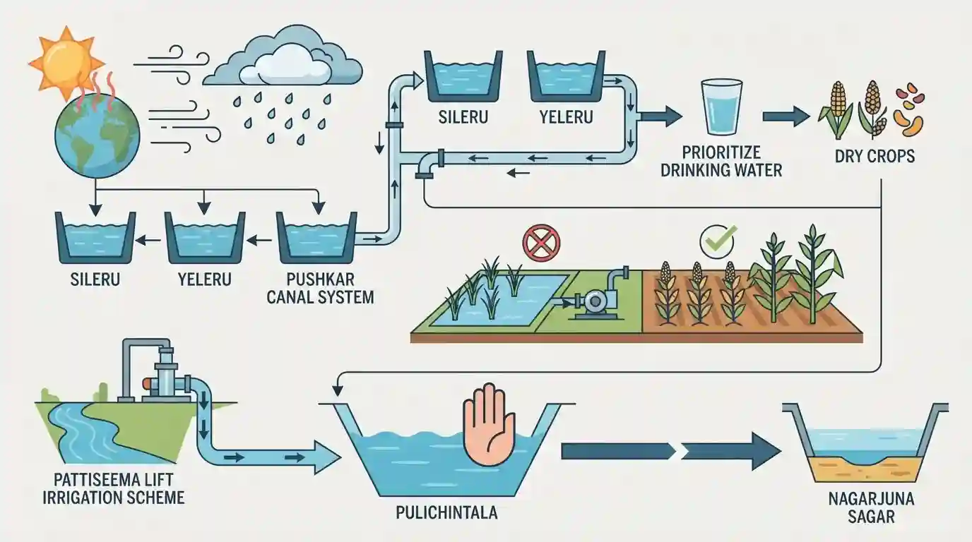
In response to the potential impact of El Niño on monsoon rainfall, the Andhra Pradesh government has tightened water management strategies for the upcoming Kharif season. Water Resources Minister Nimmala Rama Naidu directed officials to prioritize drinking water and dry crops, utilizing resources from the Sileru, Yeleru, and Pushkar Canal systems. Farmers are being actively encouraged to shift from water-intensive paddy to low-water dry crops in upland areas. Crucially, water transferred through the Pattiseema Lift Irrigation Scheme and stored in the Pulichintala project will be conserved strictly for essential needs until the Nagarjuna Sagar reservoir receives sufficient inflows.
ముఖ్య అంశాలు
- The Andhra Pradesh government is implementing strict water management measures for the Kharif season due to anticipated monsoon uncertainties caused by El Niño.
- Water from the Pushkar Canal, Yeleru system, Pattiseema Lift Irrigation Scheme, and Pulichintala project will be prioritized for drinking purposes and dry crops until the Nagarjuna Sagar reservoir receives adequate inflows.
- Sileru waters will be utilized to support the irrigation needs of the Godavari delta region.
- Farmers in upland areas are being encouraged to shift from water-intensive paddy cultivation to low-water-consuming dry crops.
ముఖ్యమైన పదాలు
Pattiseema Lift Irrigation Scheme

A pioneering river interlinking project in Andhra Pradesh that lifts surplus water from the Godavari River and channels it into the Krishna River basin to address regional water shortages.
UPSC context
GS Paper I (Geography) & GS Paper III (Agriculture/Water Resources); tests knowledge of river interlinking and major irrigation schemes.
Polavaram Right Main Canal
A major 174 km long canal of the Polavaram national project that facilitates the diversion of Godavari River water into the Krishna River basin upstream of Prakasam Barrage.
UPSC context
GS Paper III (Infrastructure/Water Resources); tests understanding of national water grids and interstate irrigation infrastructure.
Pulichintala Project
A multipurpose balancing reservoir constructed across the Krishna River, serving irrigation, hydroelectric power generation, and flood control needs for coastal Andhra Pradesh and Telangana.
UPSC context
GS Paper I (Physical Geography) & GS Paper III (Infrastructure); tests geographic location of major dams and river basin developments.
Nagarjuna Sagar Project
One of India's largest multipurpose river valley projects, featuring a massive masonry dam built across the Krishna River to provide extensive irrigation and hydroelectricity.
UPSC context
GS Paper I (Geography) and GS Paper III (Agriculture); tests understanding of landmark multi-purpose river valley developments.
El Niño
A periodic climate phenomenon characterized by abnormal ocean surface warming in the central and eastern equatorial Pacific, disrupting global weather patterns and weakening the Indian monsoon.
UPSC context
GS Paper I (Physical Geography - Climatology); tests knowledge of ocean-atmosphere couplings, ENSO dynamics, and their agricultural impact.
ప్రిలిమ్స్ ఉచ్చు
"Sileru is a key tributary of the Krishna River."
Sileru is a tributary of the Sabari River, which is a left-bank tributary of the Godavari, not the Krishna River. UPSC often mixes river basins when inter-linking projects are in the news.
అనుసంధానమైన స్థిర భావనలు
How does El Niño affect the Indian Southwest Monsoon?
- Pacific Warming: Abnormal warming of the central and eastern equatorial Pacific Ocean alters atmospheric pressures.
- Walker Circulation Shift: It shifts the Walker Circulation eastward, leading to high pressure and subsidence over the western Pacific and Indian Ocean.
- Suppressed Rainfall: This setup weakens the trade winds, generally resulting in suppressed monsoon rainfall and drought conditions over the Indian subcontinent.
What is the geographic significance of the Pattiseema Lift Irrigation Scheme?
- Basin Interlinking: It is India's first operational river interlinking project, connecting the Godavari and Krishna river basins.
- Drought Mitigation: It diverts surplus Godavari water (which would otherwise flow into the sea) into the Krishna basin to aid drought-prone regions like Rayalaseema.
- Canal Mechanism: Water is lifted and transported via the Polavaram Right Main Canal to the Prakasam Barrage.
అంతర-అంశ నమూనాలు
Climate-Resilient Agriculture & Millets
The push to shift from paddy to dry crops during El Niño aligns with the national push for Shree Anna (millets) to ensure food and water security under climate stress.
Interstate River Water Disputes
Management of the Pulichintala and Nagarjuna Sagar projects frequently triggers Godavari-Krishna water sharing disputes between Andhra Pradesh and Telangana, linking physical geography with federalism.

Expect a map-based question linking Godavari-Krishna tributaries (Sileru, Sabari) with specific irrigation projects (Pattiseema).
అనుసంధాన PYQలు · 2
అనుసంధాన PYQలు · 2
- 2019APPSC_PRELIMSGS1
El-Nino is a complex weather system that appears once every three to seven years. Consider the following statements in this regard : A. The appearance of warm currents off the Coast of Peru in the Eastern Pacific. B. The word El-Nino means 'Christ Child' because the current appears around Christmas in December. C. El-Nino was one of the reasons for the deficit rainfall in India (2014). Which of the statements given above is/are correct ?
- 2023APPSC_PRELIMSGS1
Polavaram Project is a
