NASA ISRO NISAR Satellite Launch and Radar Technology
Source:The Hindu ↗
Why It Matters
NISAR represents a major milestone in international space cooperation (NASA-ISRO) and advanced Earth observation. Its dual-frequency radar and SweepSAR technology will provide crucial data for monitoring ecosystems, climate change, and natural disasters, making it highly relevant for UPSC questions on satellite applications, ISRO missions, and space-related S&T developments.
Summary
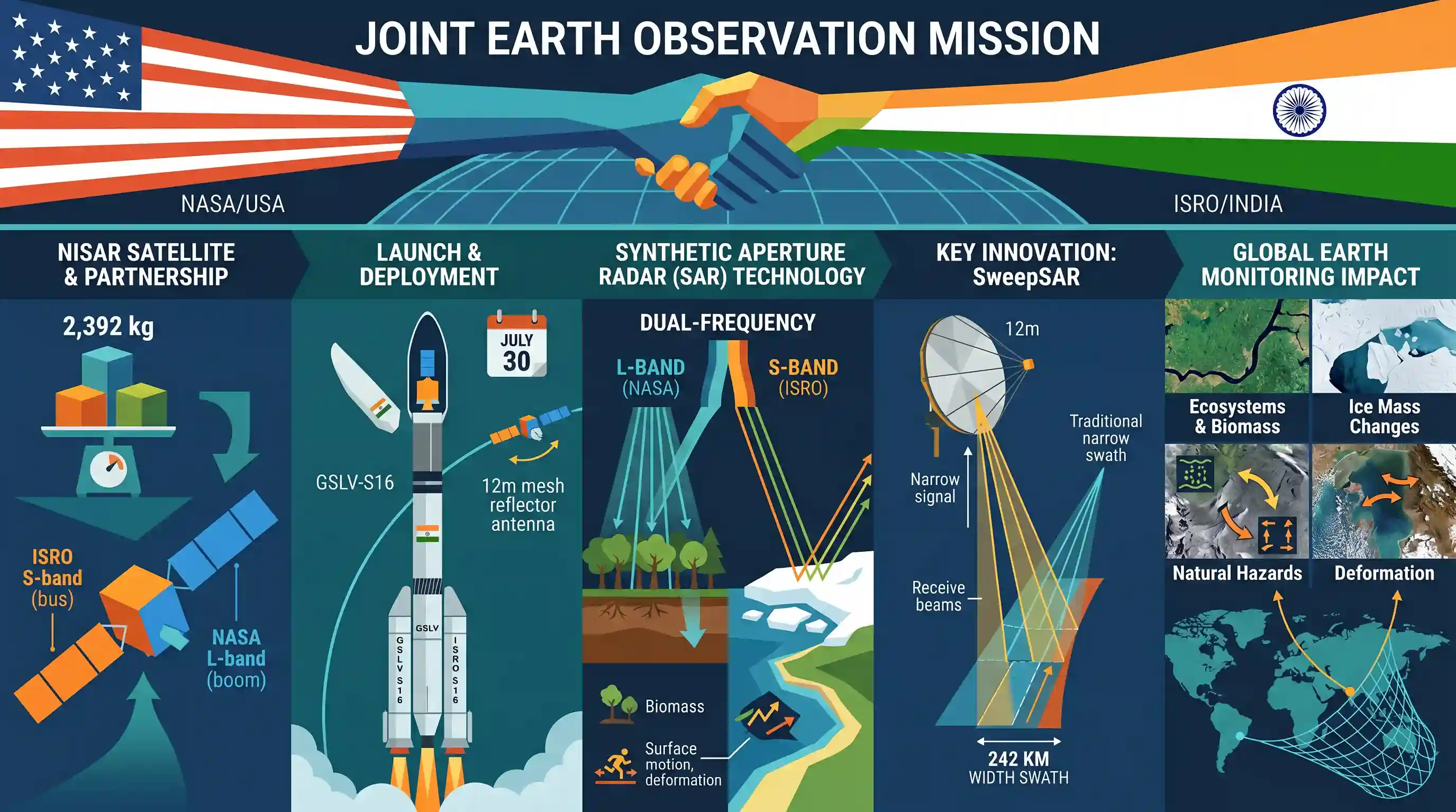
The NASA-ISRO Synthetic Aperture Radar (NISAR) satellite, a pioneering Earth observation mission jointly developed by ISRO and NASA, is scheduled for launch on July 30 aboard the GSLV-S16 vehicle. The 2,392 kg satellite is uniquely equipped with a dual-frequency Synthetic Aperture Radar (NASA's L-band and ISRO's S-band) and a 12m unfurlable mesh reflector antenna. Deploying SweepSAR technology for the first time, NISAR will provide high spatial resolution imagery with a 242 km swath, marking a significant milestone in international space cooperation and Earth monitoring capabilities.
Key Points
- The NASA-ISRO Synthetic Aperture Radar (NISAR) satellite is set to launch on July 30 using the GSLV-S16 launch vehicle.
- Weighing 2,392 kg, it is the first Earth observation satellite to carry a dual-frequency Synthetic Aperture Radar, featuring NASA’s L-band and ISRO’s S-band.
- The satellite features a 12-meter unfurlable mesh reflector antenna from NASA integrated into ISRO’s modified 13k satellite bus.
- NISAR will monitor the Earth with a 242 km swath, providing high spatial resolution data utilizing SweepSAR technology for the first time.
Important Terms
NISAR (NASA-ISRO Synthetic Aperture Radar)

A joint NASA-ISRO Earth-observation mission using dual-frequency radar to map the globe every 12 days, monitoring ecosystem changes, natural hazards, and ice-sheet collapse.
UPSC context
GS Paper III (Science & Technology); a landmark in India-US space cooperation and critical for global climate and disaster monitoring.
Synthetic Aperture Radar (SAR)
An active remote sensing technology using microwave pulses to create high-resolution images, capable of penetrating clouds, darkness, and rain to observe Earth's surface.
UPSC context
GS Paper III; relevant for remote sensing applications in agriculture, internal security, and disaster management.
SweepSAR Technology
An advanced radar technique used by NISAR to provide high-resolution imagery over an exceptionally wide swath (242 km), overcoming traditional radar coverage limitations.
UPSC context
GS Paper III; tests awareness of cutting-edge space technology and its first spaceborne implementation in NISAR.
L-band and S-band Radar
Microwave frequency ranges where L-band (1-2 GHz) penetrates thick vegetation/soil and S-band (2-4 GHz) monitors surface features and ionospheric effects.
UPSC context
GS Paper III; technical awareness of electromagnetic spectrum applications in multi-purpose satellite missions.
GSLV (Geosynchronous Satellite Launch Vehicle)
ISRO’s heavy-lift launch vehicle with three stages, including an indigenous cryogenic upper stage, used to place NISAR into its specific Sun-Synchronous Orbit.
UPSC context
GS Paper III; core topic for India's indigenous launch capabilities and space infrastructure.
Prelims Trap
"NISAR relies on optical imaging and sunlight, making it unable to capture data through dense cloud cover or at night."
False. NISAR uses Synthetic Aperture Radar (SAR), an active remote sensing technology that emits its own microwaves. It can penetrate clouds, rain, and darkness for 24/7 observation.
Static Concepts Connected
What distinguishes Active from Passive Remote Sensing in satellites?
- Active Sensors: Emit their own energy (e.g., radar, SAR) to scan targets, enabling 24/7 all-weather observation.
- Passive Sensors: Detect natural energy (sunlight or thermal radiation) reflected/emitted by the Earth, making them ineffective through clouds or darkness.
Why is the GSLV used for NISAR instead of the usual PSLV?
- Payload Weight: Most Indian Earth observation satellites launch via PSLV, but NISAR weighs 2,392 kg, which exceeds PSLV's standard Sun-Synchronous Orbit (SSO) carrying capacity.
- GSLV Capacity: GSLV Mk-II is designed for heavier payloads, capable of placing up to 2,500 kg in GTO and up to 5,000 kg in Low Earth Orbit (LEO).
Cross-Topic Patterns
SAR for Disaster Management
NISAR's S-band will measure surface deformations at the millimeter level, directly aiding GS3 Disaster Management via early warning for landslides, earthquakes, and land subsidence.
Cryosphere and Biomass Tracking
NASA's L-band penetrates forest canopies, linking space tech to GS3 Environment for precise tracking of glacial melt, ice-sheet dynamics, and global carbon biomass mapping.

A multi-statement Prelims 2026 question will likely test NISAR's active SAR tech, L-band vs S-band functions, and its GSLV launch vehicle.
Linked PYQs · 2
Linked PYQs · 2
- 2024PrelimsGS1
Consider the following activities : 1. Identification of narcotics on passengers at airports or in aircraft 2. Monitoring of precipitation 3. Tracking the migration of animals In how many of the above activities can the radars be used?
- 2015MainsGS3
What do you understand by 'Standard Positioning Systems' and 'Precision Positioning Systems' in the GPS era? Discuss the advantages India perceives from its ambitious IRNSS programme employing just seven satellites.
