Early Warning System for Ghepan Glacial Lake
Source:the-tribune ↗
Why It Matters
With rising global temperatures, Himalayan glacial lakes are expanding rapidly, increasing the risk of GLOFs. The deployment of real-time monitoring technology and community preparedness in vulnerable regions like Lahaul-Spiti is vital for disaster risk reduction and protecting downstream ecosystems and populations.
Summary
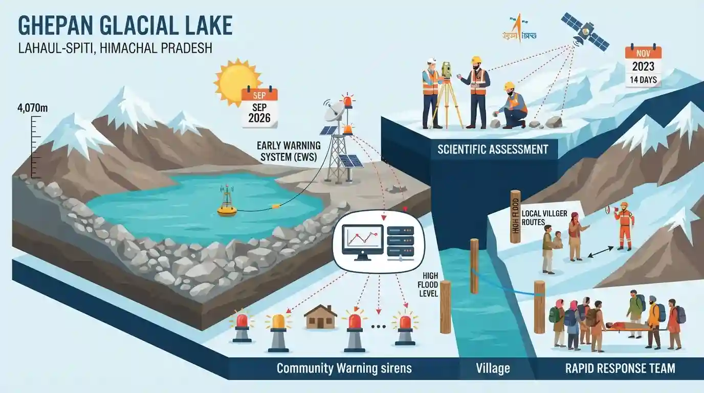
An Early Warning System (EWS) developed by C-DAC Thiruvananthapuram is scheduled to be installed in September 2026 at Ghepan Glacial Lake (altitude 4,070m) in Lahaul-Spiti, Himachal Pradesh. Backed by the NDMA, the EWS will continuously monitor lake levels to provide real-time alerts against Glacial Lake Outburst Floods (GLOFs). Additionally, the Geological Survey of India (GSI) is conducting a 14-day scientific assessment following a November 2023 expansion alert from ISRO, while local administrations are establishing High Flood Level markings and Rapid Response Teams to boost community-level disaster preparedness.
Key Points
- Installation of an Early Warning System (EWS) scheduled for September 2026 at Ghepan Glacial Lake, located at an altitude of approximately 4,070 metres in Lahaul-Spiti, Himachal Pradesh.
- The EWS is developed by the Centre for Development of Advanced Computing (C-DAC), Thiruvananthapuram, following a successful trial of a similar system at Sissu Lake. It will continuously monitor lake levels and critical parameters with support from the NDMA.
- The Geological Survey of India (GSI) is deploying a five-member expert team for a 14-day comprehensive scientific study to map the lake, identify hazard-prone zones, assess depth/water flow, and collect meteorological data.
- The initiative stems from a November 2023 alert by the Indian Space Research Organisation (ISRO) warning of significant expansion of Ghepan Lake beyond its normal limits.
- Local risk mitigation efforts include identifying 34 vulnerable locations between Sissu and the Himachal boundary, initiating High Flood Level (HFL) marking at 32 sites, and setting up local Rapid Response Teams in Sissu and Shashin villages.
- A district-level GLOF Monitoring Committee involving multi-departmental officials, mountaineers, and experts is being established for periodic field inspections of geological and environmental hazards.
Important Terms
Glacial Lake Outburst Flood (GLOF)

A sudden, catastrophic release of water stored in a glacial lake, often caused by moraine dam failure, avalanches, or rapid glacier melt, leading to severe downstream flooding.
UPSC context
GS-I (Geography) and GS-III (Disaster Management). Tests understanding of climate change hazards in the Himalayan region.
Early Warning System (EWS)
An integrated set of monitoring, forecasting, and communication technologies designed to detect hazards early and disseminate timely alerts to vulnerable downstream populations.
UPSC context
GS-III (Disaster Management). Crucial for planning resilient infrastructure and risk-mitigation systems in high-altitude regions.
High Flood Level (HFL) marking
The process of identifying and marking the maximum physical water level reached or predicted during severe floods to guide local community awareness and land-use planning.
UPSC context
GS-III (Disaster Management). Tested as a non-structural risk-reduction measure for flood mitigation and community preparedness.
National Disaster Management Authority (NDMA)
India's apex statutory body for disaster management, established under the Disaster Management Act, 2005, responsible for formulating policies, plans, and approvals for disaster mitigation.
UPSC context
GS-III (Disaster Management). Tests knowledge of India's institutional framework for handling disasters and high-altitude hazards.
Geological Survey of India (GSI)
An attached office of the Ministry of Mines, responsible for conducting geological surveys, hazard mapping (landslides, GLOFs), and scientific assessments of terrains across India.
UPSC context
GS-I (Geography) and GS-III (Disaster Management). Evaluates the role of premier scientific agencies in hazard assessment.
Centre for Development of Advanced Computing (C-DAC)
A premier Research and Development organization under the Ministry of Electronics and Information Technology, specializing in supercomputing, advanced communication systems, and remote telemetry solutions.
UPSC context
GS-III (S&T and Disaster Management) regarding indigenous technological developments and remote monitoring systems.
Indian Space Research Organisation (ISRO)
India's national space agency, operating under the Department of Space, which plays a vital role in monitoring environmental changes and hazards using satellite-based remote sensing.
UPSC context
GS-III (S&T: Space). Tests the application of remote sensing and satellite surveillance in early hazard tracking.
Prelims Trap
Ghepan Glacial Lake drains directly into the Spiti River, contributing to the Satluj river basin.
Ghepan Lake drains into Sissu Nullah, which joins the Chandra River, placing it firmly in the Chenab river basin, not the Satluj or Spiti basins.
Static Concepts Connected
What is the geography and hydrology of the Chandra River basin?
- Origin and Course: Rises near the Bara-lacha Pass, feeding Chandra Taal, and flows through Lahaul before joining the Bhaga River at Tandi to form the Chenab River.
- Glacial Feeders: Fed by prominent glaciers like Bara Shigri, Ghepang, and Samudra Tapu, making it highly vulnerable to climate-induced glacial lake formations.
- Key Tributaries: Receives inflows from high-altitude torrents like Sissu Nullah, which directly drains the highly vulnerable, expanding Ghepan Glacial Lake.
What are the primary triggers of Glacial Lake Outburst Floods (GLOFs)?
- Moraine Failure: Unconsolidated moraine dams fail due to internal piping erosion, hydrostatic pressure, or structural degradation caused by thawing permafrost.
- Displacement Waves: Avalanches, rockfalls, or calving glaciers plunging into the lake trigger massive surge waves that overtop and breach the dam.
- Extreme Weather: Rapid snowmelt or sudden cloudbursts overload the lake volume, instantly exceeding the holding capacity of natural moraine barriers.
Cross-Topic Patterns
Deity culture and community disaster response
HP's traditional institutions, like the Ghepan oracle in Lahaul, act as indigenous risk-prediction systems, complementing modern satellite-based GLOF early warning networks.
Himalayan deglaciation and Indus Water Treaty
Accelerated glacier melting in HP basins (Chandra/Chenab) alters seasonal run-off patterns, impacting downstream hydro-power commitments and transboundary water sharing under the Indus Water Treaty.

HPAS may combine Ghepan Lake's geographic outlet (Chandra River), its CDAC-developed EWS, and HIMCOSTE's glacial lake census into one MCQ.
Linked PYQs · 3
Linked PYQs · 3
- 2024HPAS_PRELIMSGS1
Given below are two statements : Statement I : Bara Shigri glacier was first surveyed by Walker and Poscoe in 1906. Statement II : Bara Shigri is the largest glacier in the state of Himachal Pradesh. In the light of the above statements, choose the most appropriate answer from the options given below :
- 2023HPAS_PRELIMSGS1
Given below are two statements : Statement I : Chandra Tal lake in Lahaul and Spiti district of Himachal Pradesh is about 6000 m above sea level. Statement II : Suraj Tal lake is the source of Spiti river in Himachal Pradesh. In the light of the above statements, choose the most appropriate answer from the options given below :
- 2010HPAS_PRELIMSGS1
In which District of Himachal Pradesh is Surajital lake ?
