Himalayan glacial ice patch collapse and new disaster risks
Source:The Hindu ↗
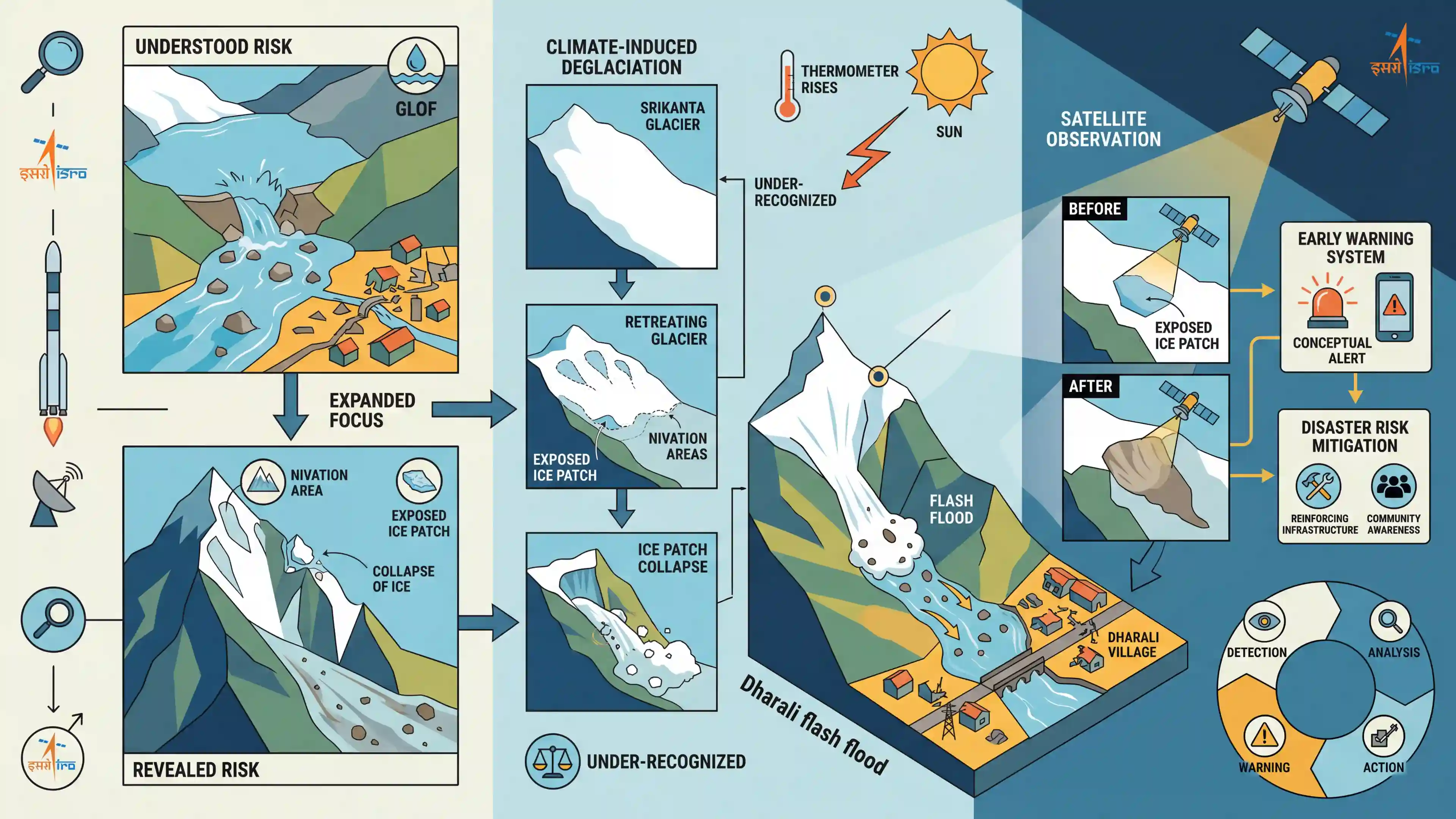
Why It Matters
The article highlights a newly identified cryo-hydrological hazard—the collapse of exposed ice patches in nivation hollows—which adds to the complexity of climate-induced disasters in the Himalayas. It underscores the importance of remote sensing and satellite surveillance in strengthening disaster preparedness and early warning frameworks, highly relevant to GS3 Disaster Management and Environment.
Summary
A recent study by ISRO scientists, analyzing the August 2025 Dharali flash floods in Uttarakhand, reveals that exposed ice patches on retreating Himalayan glaciers are an under-recognized and severe threat. The floods were caused by the sudden collapse of an ice patch in the nivation area of the Srikanta glacier, driven by climate-induced deglaciation. The findings emphasize that disaster management in high-altitude regions must expand its focus beyond Glacial Lake Outburst Floods (GLOFs) to include these smaller cryospheric instabilities. The study also highlights the critical role of satellite observation in detecting such vulnerabilities for early warning and disaster risk mitigation.
Key Points
- The August 2025 flash floods in Dharali, Uttarakhand, were triggered by the collapse of an exposed ice patch in the nivation zone of the Srikanta glacier, not a traditional Glacial Lake Outburst Flood (GLOF).
- Warming temperatures and ongoing deglaciation are causing seasonal snow and firn to thin out, exposing ice patches on steep nivation hollows that are highly vulnerable to fragmentation and collapse.
- Exposed ice patches react quickly to temperature changes and can suddenly release ice, meltwater, and debris, resulting in severe cryo-hydrological hazards downstream.
- The ISRO study stresses the need to broaden disaster risk reduction strategies in the Himalayas beyond GLOFs to include these smaller, often overlooked cryospheric instabilities.
- Pre-event satellite imagery and remote sensing are crucial for identifying vulnerable nivation hollows during the ablation period, functioning as a vital component for early-warning systems.
Important Terms
Indian Space Research Organisation (ISRO)

India's national space agency responsible for space research and planetary exploration. In disaster management, it provides satellite-based monitoring, mapping, and early warning systems for hazards like floods and glacial retreats.
UPSC context
GS-III Science & Technology/Disaster Management; relevant for space-based applications in monitoring environmental hazards and indigenous technological capabilities.
National Remote Sensing Centre (NRSC)
A primary ISRO center in Hyderabad that manages satellite data acquisition, processing, and dissemination. It plays a critical role in disaster management through real-time remote sensing of floods and glacial changes.
UPSC context
GS-III Science & Technology; tests knowledge of organizational roles in remote sensing for natural resource management and disaster mitigation.
Cryosphere
The portion of the Earth's surface where water is in solid form, including glaciers, ice sheets, and permafrost. It is a sensitive indicator of climate change and regulates global sea levels.
UPSC context
GS-I Physical Geography; fundamental concept for understanding global climate systems, water cycles, and high-altitude geomorphic processes.
Glacial Lake Outburst Flood (GLOF)
A catastrophic flood triggered by the sudden release of water from a glacial lake, often caused by dam failure due to melting, avalanches, or seismic activity.
UPSC context
GS-III Disaster Management; a high-priority Himalayan hazard frequently featured in questions regarding disaster risk reduction and climate adaptation.
Nivation
A periglacial geomorphic process involving the erosion of the ground beneath and around a snowbank through alternate freezing and thawing, often forming hollows and contributing to slope instability.
UPSC context
GS-I Physical Geography; tests specialized knowledge of landform development and periglacial processes in high-altitude environments.
Deglaciation
The widespread retreat and thinning of glaciers, leading to the exposure of land previously covered by ice. It is a primary driver of rising sea levels and altered mountain hydrology.
UPSC context
GS-III Environment/Geography; central to climate change discussions and its impact on water security and natural hazards in the Himalayas.
Prelims Trap
Flash floods originating from retreating Himalayan glaciers are exclusively caused by Glacial Lake Outburst Floods (GLOFs).
The Dharali event proves that the collapse of exposed ice patches in nivation hollows can trigger massive flash floods, completely independent of any glacial lake.
Static Concepts Connected
What is Nivation and a Nivation Hollow?
- Nivation Definition: A localized erosion process driven by repeated freeze-thaw cycles and mass wasting beneath accumulating snowbanks.
- Nivation Hollows: It carves out bowl-shaped depressions on mountainsides. Over time, as ice accumulates, these hollows can deepen and evolve into glacial cirques.
What is 'Firn' and what is its role in glacial stability?
- Definition: Partially compacted granular snow that has survived at least one ablation (melt) season. It forms the intermediate stage between fresh snow and dense glacial ice.
- Insulation Role: Firn acts as a critical protective layer. Its rapid depletion due to global warming exposes solid underlying ice patches to direct solar radiation, rendering them structurally unstable.
Cross-Topic Patterns
Space Tech + Disaster Risk Reduction (DRR)
ISRO's role in pre-event satellite observation highlights the critical overlap between Space Technology (GS-3) and Disaster Risk Reduction. Expect upcoming missions like NISAR to heavily feature in high-altitude hazard mapping.
Cryosphere hazards beyond GLOFs
This moves the climate-disaster narrative from solely GLOFs/cloudbursts to micro-level cryo-hydrological events, demanding localized updates in Hazard Zonation Mapping under NDMA guidelines.

Expect a 2026 Geography prelims question matching glacial terminology (nivation, firn, ablation) to their precise geomorphic definitions.
Linked PYQs · 3
Linked PYQs · 3
- 2014MainsGS1
Bring out the relationship between the shrinking Himalayan glaciers and the symptoms of climate change in the Indian sub-continent.
- 2017MainsGS3
'Climate change' is a global problem. How India will be affected by climate change? How Himalayan and coastal states of India will be affected by climate change?
- 2020MainsGS1
How will the melting of Himalayan glaciers have a far-reaching impact on the water resources of India?
