Bay of Bengal Depression and Andhra Pradesh Heavy Rainfall Alert
Source:The Hindu ↗
Why It Matters
This event is a classic example of tropical weather systems (low-pressure areas and depressions) originating in the Bay of Bengal, a core topic in UPSC GS1 Geography. It also highlights practical aspects of disaster management, early warning systems by the IMD, and the socio-economic impacts of extreme weather on coastal regions (GS3).
Summary
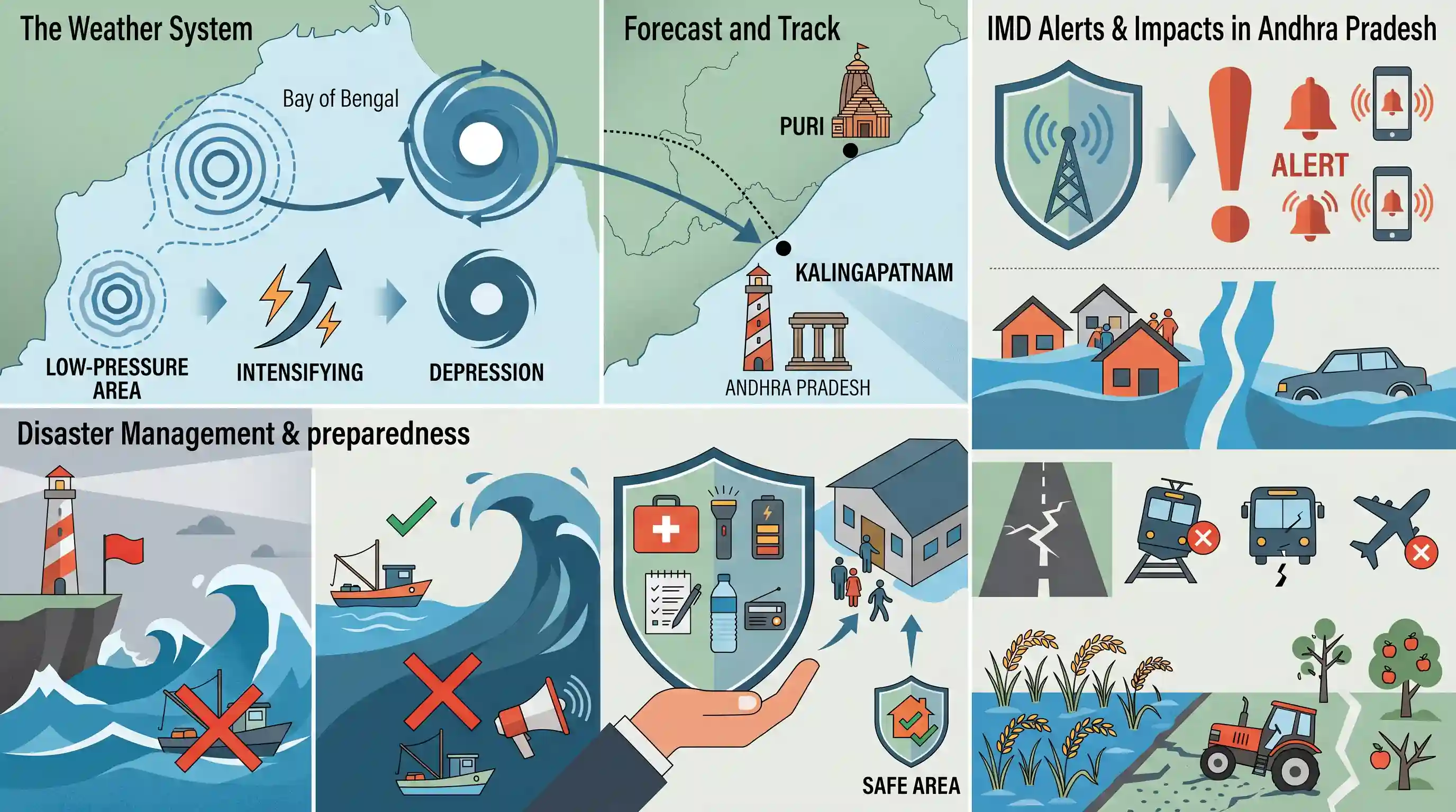
A well-marked low-pressure area in the Bay of Bengal is anticipated to intensify into a depression, leading to heavy to very heavy rainfall across Andhra Pradesh. The India Meteorological Department (IMD) has issued alerts for multiple coastal and inland districts, warning of potential flooding, waterlogging, transport disruptions, and damage to agriculture. The system is expected to cross the coast between Puri (Odisha) and Kalingapatnam (Andhra Pradesh), prompting advisories for fishermen to avoid the sea due to rough conditions.
Key Points
- A well-marked low-pressure area over the Bay of Bengal is expected to intensify into a depression.
- The weather system is projected to cross the South Odisha and North Andhra Pradesh coasts between Puri and Kalingapatnam.
- The India Meteorological Department (IMD) has issued orange and yellow alerts, predicting heavy to very heavy rainfall, thunderstorms, and strong surface winds for several districts in Andhra Pradesh.
- Expected impacts include localized flooding, waterlogging of roads and low-lying areas, traffic disruptions, and potential damage to vulnerable crops.
- Fishermen are advised to avoid the sea due to squally weather with wind speeds reaching up to 60 kmph along the coast.
Important Terms
India Meteorological Department (IMD)

The principal government agency under the Ministry of Earth Sciences responsible for meteorological observations, weather forecasting, and seismology. It serves as a Regional Specialized Meteorological Centre for tropical cyclones.
UPSC context
GS Papers I & III. Tests institutional roles in forecasting geophysical phenomena and managing weather-related disasters.
Atmospheric Depression
A low-pressure weather system where air circulates inwards; in the Indian context, it is a tropical system with sustained wind speeds between 31 and 49 km/h.
UPSC context
GS Paper I (Geography). Tests conceptual understanding of tropical cyclone formation stages and monsoon dynamics.
Andhra Pradesh State Disaster Management Authority (APSDMA)
A statutory body established under the Disaster Management Act, 2005, responsible for formulating policies and coordinating emergency responses and disaster risk reduction within Andhra Pradesh.
UPSC context
GS Paper III (Disaster Management). Tests knowledge of state-level institutional frameworks and the three-tier disaster management structure.
Disaster Management Act, 2005
The primary legislation providing the legal framework for managing disasters in India. It mandated the creation of the NDMA, SDMAs, and the National Disaster Response Force (NDRF).
UPSC context
GS Papers II & III. Tests the legislative basis for disaster response and inter-agency coordination.
Low-Pressure Area (LPA)
A region where atmospheric pressure is lower than the surrounding area, causing air to rise and typically resulting in unsettled weather, cloud formation, and precipitation.
UPSC context
GS Paper I (Geography). Fundamental concept for understanding wind patterns, cyclone triggers, and monsoon intensity.
Bay of Bengal (Vulnerability)
A region highly prone to intense weather systems due to high sea surface temperatures and a funnel-like shape that amplifies storm surges along India's east coast.
UPSC context
GS Paper I (Geography). Tests geographical factors affecting regional climate and comparative vulnerability of India's coastlines.
Prelims Trap
"A weather system is named as a Cyclonic Storm as soon as it intensifies into a Depression."
A Depression (31-49 kmph) is merely an early developmental stage. A system must reach sustained wind speeds of at least 62 kmph to be officially classified—and named—as a Cyclonic Storm.
Static Concepts Connected
How does the IMD classify cyclonic disturbances in the North Indian Ocean by wind speed?
- Depression: Characterized by maximum sustained surface wind speeds ranging between 31 and 49 kmph.
- Deep Depression: Wind speeds ranging from 50 to 61 kmph.
- Cyclonic Storm: Wind speeds of 62 kmph or more. At this stage, the system is officially named.
What are the key regional divisions of India's Eastern Coastal Plains?
- Northern Circars: The coastal stretch between the Mahanadi and Krishna river deltas (Odisha and AP). It is highly vulnerable to Bay of Bengal cyclonic systems.
- Coromandel Coast: The southern coastal stretch between the Krishna and Kaveri rivers, known for receiving the bulk of its rainfall from the retreating Northeast Monsoon.
Cross-Topic Patterns
Urban flooding + Sponge Cities
Severe depressions frequently expose inadequate urban drainage. This links directly to the 'Sponge City' concept and NDMA guidelines on mitigating climate-induced urban flooding.
INCOIS vs IMD mandates
While the IMD issues mainland weather alerts, INCOIS handles marine advisories and Ocean State Forecasts (OSF) for fishermen. UPSC frequently tests these distinct institutional mandates.

Expect a 2026 multi-statement prelims question matching wind-speed thresholds (Depression vs Cyclonic Storm) with INCOIS marine duties.
Linked PYQs · 4
Linked PYQs · 4
- 2022MainsGS1
Discuss the meaning of colour-coded weather warnings for cyclone prone areas given by India Meteorological Department.
- 2024MainsGS1
What is sea surface temperature rise? How does it affect the formation of tropical cyclones?
- 2014MainsGS1
Tropical cyclones are largely confined to South China Sea, Bay of Bengal and Gulf of Mexico. Why?
- 2024MainsGS3
Flooding in urban areas is an emerging climate-induced disaster. Discuss the causes of this disaster. Mention the features of two such major floods in the last two decades in India. Describe the policies and frameworks in India that aim at tackling such floods.
