IMD Issues Orange Alert as Heavy Rains Lash Uttarakhand Districts
Source:dd-india ↗
Why It Matters
Uttarakhand is ecologically fragile and highly susceptible to climate-induced disasters such as flash floods and landslides. Knowledge of the state's geography (rivers like the Tamsa), local cultural landmarks (Tapkeshwar Mahadev Temple), and disaster response mechanisms is crucial for UKPSC PCS Prelims.
Summary
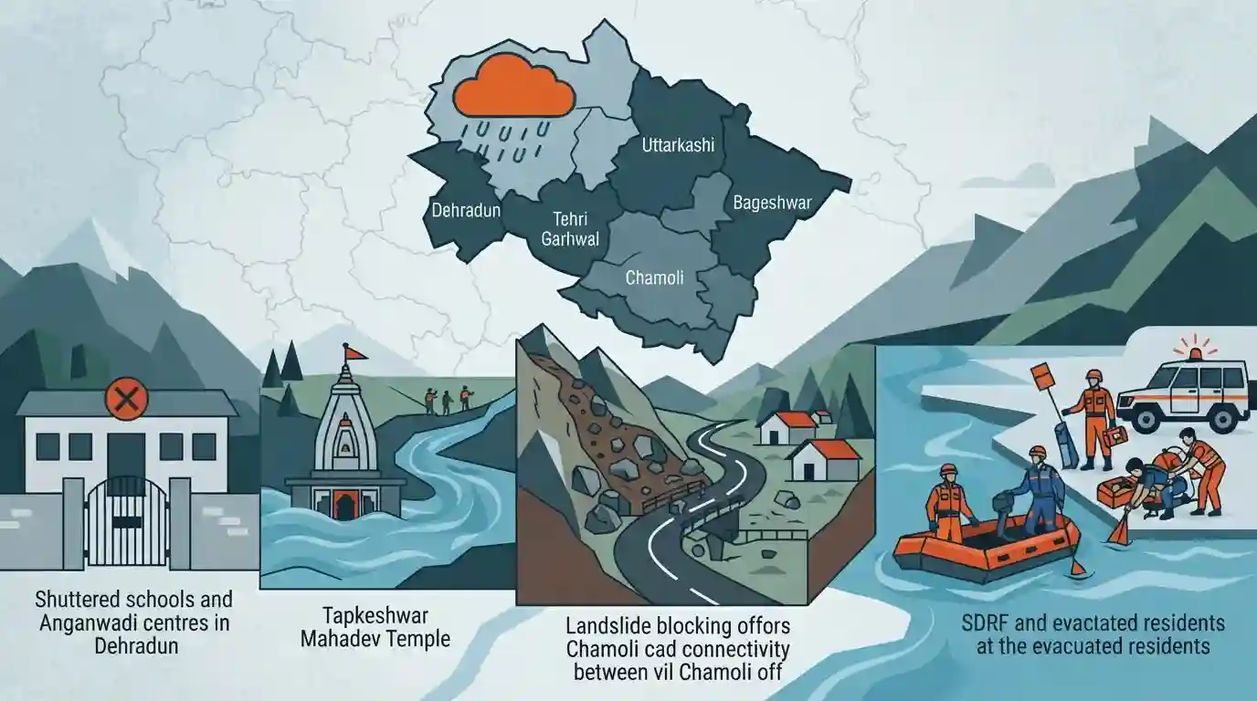
In response to relentless heavy rainfall and an 'Orange Alert' issued by the India Meteorological Department (IMD), schools and Anganwadi centres across Dehradun have been shut. The severe weather affects several districts in Uttarakhand, including Bageshwar, Tehri Garhwal, and Uttarkashi. The rising water levels of the Tamsa River have impacted the Tapkeshwar Mahadev Temple. Additionally, a landslide in Chamoli's Khainuri village has disrupted local connectivity. Chief Minister Pushkar Singh Dhami has placed the SDRF and NDRF on high alert to handle emergencies and advised residents to avoid vulnerable areas.
Key Points
- Dehradun district administration ordered the closure of all schools and Anganwadi centres due to heavy rainfall warnings.
- The IMD has issued an Orange Alert forecasting heavy rainfall, thunderstorms, and lightning in Dehradun, Bageshwar, Tehri Garhwal, and Uttarkashi districts.
- Water levels in the Tamsa River, which flows through the renowned Tapkeshwar Mahadev Temple in Dehradun, have risen sharply.
- Chief Minister Pushkar Singh Dhami has directed disaster management agencies (SDRF and NDRF) to remain on high alert for prompt rescue operations.
- A severe landslide triggered by heavy rains has disrupted road connectivity for 120 families in Khainuri village, located in Chamoli district.
Important Terms
India Meteorological Department (IMD)

The principal government agency under the Ministry of Earth Sciences responsible for meteorological observations, weather forecasting, and seismology. It provides critical early warnings for hazards like cyclones, floods, and heatwaves.
UPSC context
Relevant for GS Paper 1 (Geography) and GS Paper 3 (Disaster Management) regarding climate services and early warning systems.
National Disaster Response Force (NDRF)
India's specialized, multi-skilled disaster response agency under the Ministry of Home Affairs. Raised under the Disaster Management Act, 2005, it handles major natural and human-induced disasters nationwide.
UPSC context
Important for GS Paper 3 (Disaster Management), assessing understanding of India's national disaster governance and emergency rescue capabilities.
State Disaster Response Force (SDRF)
A dedicated state-level disaster response force established under the Disaster Management Act, 2005. Modeled after the NDRF, it provides rapid, specialized intervention for local natural and man-made emergencies.
UPSC context
Crucial for GS Paper 3 (Disaster Management), testing knowledge of decentralized emergency response and state-level institutional frameworks.
Orange Alert
A color-coded weather warning issued by the IMD indicating a need to 'Be Prepared.' It signifies severe weather conditions, like heavy rainfall, likely to disrupt daily life, transport, and power.
UPSC context
Tested in GS Paper 3 (Disaster Management) under early warning mechanisms and risk reduction strategies for climate extremes.
Tamsa River
A Himalayan river flowing through Dehradun, Uttarakhand. It recently swelled due to intense rainfall, inundating the historic Tapkeshwar Mahadev cave temple situated on its banks.
UPSC context
Relevant for GS Paper 1 (Geography), focusing on Himalayan drainage systems and vulnerability to flash floods and extreme weather.
Prelims Trap
"An 'Orange Alert' by the IMD signifies that local authorities must 'Take Immediate Action' and evacuate."
An Orange alert actually means "Be prepared" (stay updated on disruptions). It is the Red Alert that officially signals authorities and citizens to "Take action" against extreme danger.
Static Concepts Connected
Why is the Himalayan region highly vulnerable to frequent landslides?
- Tectonic instability: The ongoing collision between the Indian and Eurasian plates makes the region highly seismically active, constantly weakening underlying rock structures.
- Fragile geology: The Himalayas are young fold mountains characterized by steep slopes and loose, unconsolidated sedimentary soils that are highly prone to slipping during heavy rains.
- Anthropogenic stress: Deforestation, unplanned urbanization, and heavy infrastructure projects (like dams and highways) alter natural drainage and destabilize sensitive slopes.
How do Doppler Weather Radars (DWR) aid in Himalayan disaster management?
- Precipitation tracking: DWRs use the Doppler effect to track the movement and velocity of water droplets, allowing meteorologists to accurately measure storm intensity and wind speeds.
- Nowcasting: They enable real-time, short-range forecasting (typically 0-3 hours) crucial for issuing immediate warnings for highly localized, rapid-onset events like cloudbursts and flash floods.
Cross-Topic Patterns
Himalayan ecology vs Infrastructure push
Recurring landslides in Chamoli and Uttarakhand are frequently linked in Mains to the carrying capacity debate and the ecological impact of unregulated infrastructure expansion in young fold mountains.
Nowcasting and Proactive Disaster Prep
The use of Doppler radars to trigger early SDRF deployment demonstrates NDMA's mandated shift from post-disaster reactive relief to proactive risk mitigation and early warning integration.

Expect a Prelims match-the-following on IMD colour codes, or a Mains question linking Himalayan carrying capacity to recurring landslides.
Linked PYQs · 4
Linked PYQs · 4
- 2021UKPSC_PRELIMSGS1
At which place in Uttarakhand did the Indian, Meteorological Department install a Doppler Weather Radar?
- 2025UKPSC_PRELIMSGS1
Consider the following statements and select the correct answer from the options given below : Statement 1 : Uttarakhand is highly vulnerable to climate change. Statement 2 : Climate change is causing water stress and depleting biodiversity in Uttarakhand.
- 2024UKPSC_PRELIMSGS1
Match the hydroelectric projects with the river on which they are constructed : | Name of Project | River | |---|---| | A. Koteshwar | 1. Asan | | B. Kulhal | 2. Alaknanda | | C. Tapoban Vishnugad | 3. Bhagirathi | | D. Vishnuprayag | 4. Dhalui | A B C D
- 2024UKPSC_PRELIMSGS1
Headquarters of which of the following is located in Dehradun, the Capital of Uttarakhand ?
