Sundarbans maritime security and arms smuggling prevention
Source:The Hindu ↗
কেন এটি গুরুত্বপূর্ণ
The event highlights vulnerabilities along the porous Indo-Bangladesh riverine and maritime borders, emphasizing the strategic importance of the Sundarbans geography in trans-national smuggling and internal security.
সারসংক্ষেপ
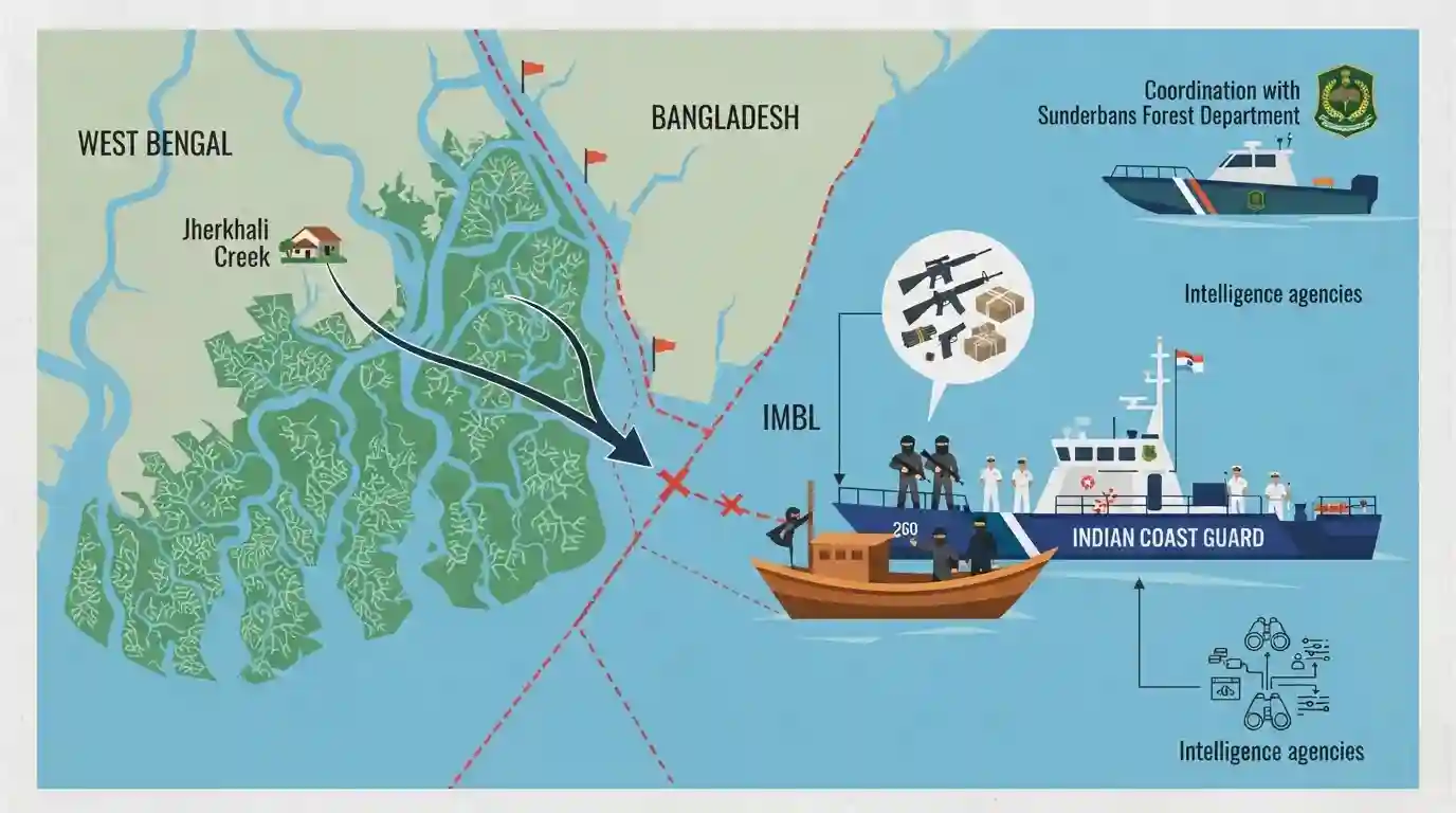
The Indian Coast Guard, in coordination with the Sunderbans Forest Department and intelligence agencies, intercepted a fishing boat near the Indo-Bangladesh International Maritime Boundary Line. Four Indian arms smugglers were arrested, and illegal weapons bound for Bangladesh were seized. The boat originated from Jherkhali Creek in the Sundarbans.
মূল বিষয়
- The Indian Coast Guard (ICG) arrested four Indian crew members for suspected trans-border arms trafficking on a fishing boat near the Indo-Bangladesh maritime boundary.
- The operation was jointly coordinated with the Sunderbans Forest Department and intelligence agencies.
- The intercepted boat had originated from Jherkhali Creek in the Sundarbans.
- Illegal weapons intended for delivery to Bangladesh were seized and handed over to the West Bengal Marine Police.
গুরুত্বপূর্ণ শব্দ
Indian Coast Guard (ICG)

An armed force and maritime law enforcement agency established in 1978 under the Ministry of Defence. It safeguards India's territorial waters and exclusive economic zone, handling coastal security, anti-smuggling, and search-and-rescue operations.
UPSC context
GS Paper 3 (Security). Tests understanding of India's multi-tiered coastal defence architecture and border management agencies.
Marine Police Force
A specialized state-level force created under the Coastal Security Scheme (2005) to patrol shallow coastal waters alongside the Coast Guard. It forms the innermost layer of India's three-tier coastal security architecture.
UPSC context
GS Paper 3 (Security). Important for questions on centre-state coordination and the "hub-and-spoke" model in coastal policing.
Indo-Bangladesh International Maritime Boundary Line (IMBL)
The demarcated maritime boundary dividing the territorial waters of India and Bangladesh. Its sensitive, porous nature requires intelligence-led surveillance to prevent trans-border crimes like arms trafficking and illegal migration.
UPSC context
GS Paper 2 (IR) & GS 3 (Security). Tests knowledge of maritime boundary management, bilateral relations, and cross-border crime prevention.
Three-Tier Coastal Security Architecture
India's maritime defense grid comprising the State Marine Police (inner shallow waters), the Indian Coast Guard (territorial waters and EEZ), and the Indian Navy (offshore/deep seas) to combat maritime threats.
UPSC context
GS Paper 3 (Internal Security). Crucial for evaluating India's post-26/11 maritime security infrastructure and inter-agency coordination.
Sundarbans
A vast coastal mangrove forest network at the Ganges delta. Its complex, difficult-to-navigate creeks (like Jherkhali) make it highly vulnerable to illegal cross-border smuggling, requiring specialized surveillance and inter-agency efforts.
UPSC context
GS Paper 3 (Security) & GS 1 (Geography). Tests knowledge of how geographical terrain complicates border management and security operations.
প্রিলিমস ফাঁদ
State Marine Police are solely responsible for patrolling India's Exclusive Economic Zone (EEZ).
India uses a 3-tier grid: Marine Police up to 12 NM, Coast Guard from 12-200 NM (EEZ), and the Navy beyond that.
সংযুক্ত স্থির ধারণা
What constitutes India's post-26/11 three-tier coastal security grid?
- Inner Ring: State Marine Police secure shallow waters up to 12 nautical miles from the coast.
- Middle Ring: The Indian Coast Guard (ICG) patrols the Exclusive Economic Zone (12 to 200 nautical miles).
- Outer Ring: The Indian Navy patrols beyond 200 NM and coordinates overall maritime security across all layers.
How was the Indo-Bangladesh maritime boundary dispute resolved?
- UNCLOS Tribunal: It was settled in 2014 by a binding ruling of the Permanent Court of Arbitration under UNCLOS.
- Peaceful Resolution: India gracefully accepted the ruling, which awarded a majority of the disputed waters to Bangladesh, reinforcing international maritime law.
আন্তঃবিষয় প্যাটার্ন
Riverine geography dictates border security
Shifting mudflats in the Sundarbans make traditional fencing ecologically destructive and impossible, necessitating joint estuarine patrols and tech surveillance.
UNCLOS compliance + Neighbourhood First
India's 2014 acceptance of the UNCLOS maritime ruling regarding Bangladesh is frequently cited in Mains as a peaceful contrast to China's rejection of South China Sea tribunals.

Expect a multi-statement prelims question blending the 3-tier coastal security grid jurisdictions with UNCLOS tribunal mechanisms.
সংযুক্ত PYQ · 1
সংযুক্ত PYQ · 1
- 2015WBCS_PRELIMSGS1
West Bengal has international boundaries on
