Madhya Pradesh Prepares Contingency Plan for Low Rainfall Seasons
Source:visionmp ↗
Why It Matters
This article highlights the direct intersection of public administration, disaster planning, and agrarian economics in Madhya Pradesh. Understanding drought-resistant crops (like kodo-kutki), irrigation sources (like traditional wells/ponds), and technological interventions (like Agri-GIS/satellite mapping) is essential as these are frequently tested themes in the MPPSC State Service Prelims.
Summary
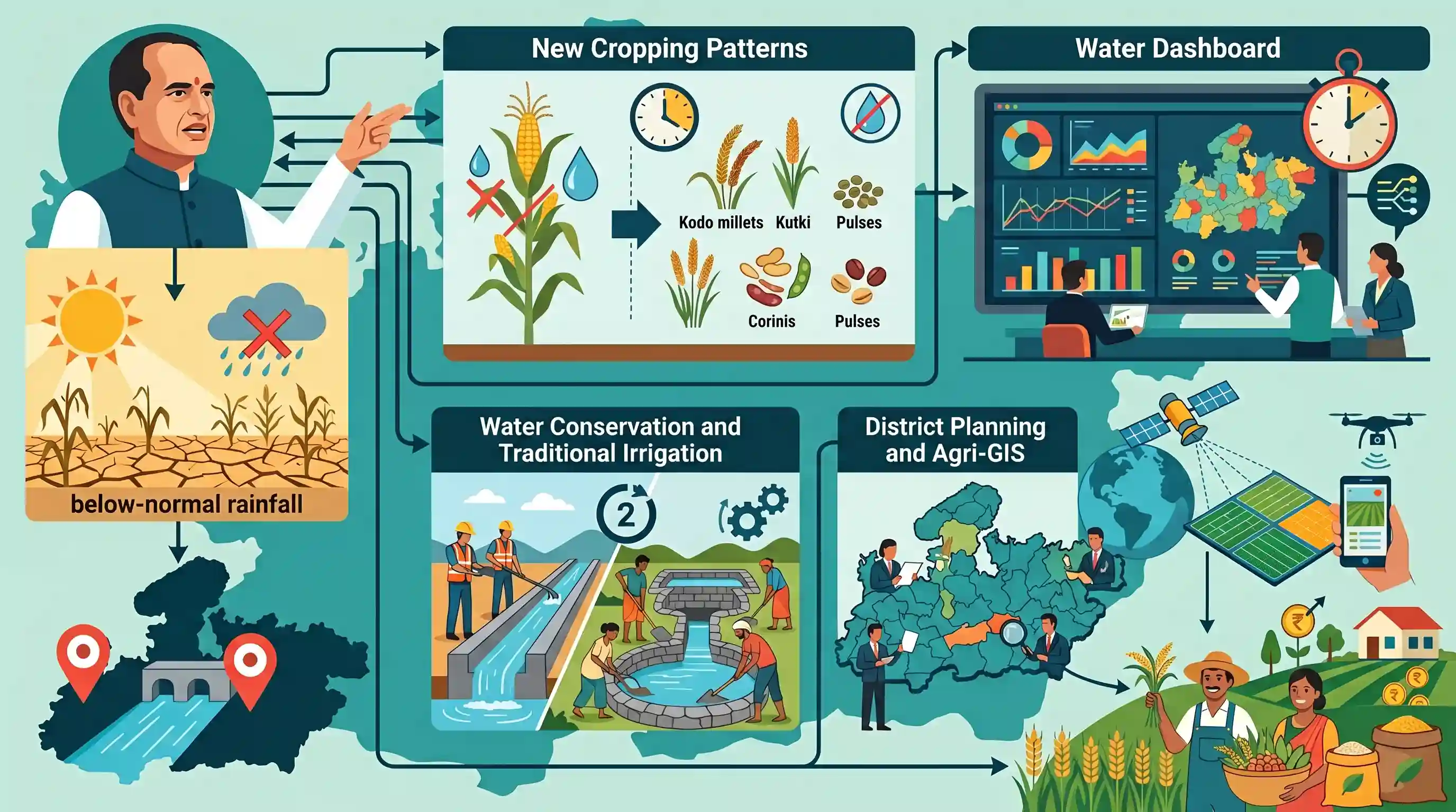
Madhya Pradesh Chief Minister Mohan Yadav has instructed key administrative and agricultural departments to prepare for potential below-normal rainfall. The state's contingency strategy focuses on promoting low-water-consuming and short-duration crops (such as Kodo, Kutki, and pulses), deploying a state-level water dashboard for real-time monitoring, and executing a two-year traditional water conservation and canal repair plan. Furthermore, district-wise contingency crop plans and satellite-based digital crop surveys will be implemented under the leadership of district collectors to protect farmers' livelihoods.
Key Points
- Chief Minister Mohan Yadav directed multiple departments to coordinate and formulate a proactive mitigation plan to address the possibility of below-normal rainfall in Madhya Pradesh.
- Farmers are encouraged to cultivate short-duration and drought-resilient crops, specifically Sorghum, Pearl Millet, Urad, Moong, Tur, and indigenous millets like Kodo and Kutki, to safeguard agricultural returns.
- A new state-level water dashboard will be developed for real-time tracking, forecasting, and early warning systems, alongside district-specific emergency water management plans led by District Collectors.
- A robust two-year water conservation plan will prioritize the restoration of traditional water bodies (ponds, wells), construction of farm ponds and recharge structures, and timely canal repairs ahead of the Rabi season.
- Technological integration will be advanced via digital crop surveys, satellite imagery for damage assessment, and the expansion of crop insurance coverage.
Important Terms
UNNATI (Agri-GIS) Project

A spatial technology platform by the Madhya Pradesh government utilizing GIS, satellite imagery, and AI/ML for precise crop mapping, real-time monitoring, and data-driven agricultural decision-making.
UPSC context
GS Paper III (Agriculture & Technology). Tests application of digital tools, remote sensing, and precision farming in disaster management and crop insurance.
Pradhan Mantri Fasal Bima Yojana (Crop Insurance)
India's flagship crop insurance scheme launched in 2016. It shields farmers from yield losses caused by non-preventable natural risks, using heavily subsidized, capped premiums.
UPSC context
GS Paper II & III (Welfare Schemes, Agriculture Risk). Tests knowledge of financial safety nets, risk mitigation, and crop insurance reforms.
Water Resources Department, Madhya Pradesh
The state agency in Madhya Pradesh responsible for constructing and managing major, medium, and minor irrigation projects, regulating inter-state river waters, and implementing flood control measures.
UPSC context
GS Paper I & III (Geography, Water Resources). Tests understanding of irrigation infrastructure, state water management, and water security policies.
Public Health Engineering (PHE) Department, Madhya Pradesh
The key state department in Madhya Pradesh responsible for planning, executing, and monitoring rural and urban safe drinking water supply schemes, sanitation services, and groundwater resource planning.
UPSC context
GS Paper II & III (Governance, Health, Infrastructure). Tests mechanisms for clean water delivery, contingency planning, and disaster response during droughts.
Agriculture Department, Madhya Pradesh
Officially the Farmers Welfare and Agriculture Development Department, this body administers state agricultural policies, crop diversification, extension services, and designs drought contingency plans.
UPSC context
GS Paper III (Agriculture). Tests understanding of regional agrarian policies, contingency crop planning, and livelihood protection during low-rainfall phases.
Prelims Trap
Canals form the primary source of irrigation in Madhya Pradesh due to major river basins like Narmada and Chambal.
Despite major river systems like the Narmada and Chambal, wells and tube-wells are the dominant source, accounting for ~66% of MP's irrigated area, while canals contribute only 18%.
Static Concepts Connected
What are the four primary types of droughts recognized in disaster management?
- Meteorological: Occurs when there is a significant, prolonged deficit in precipitation compared to the historical climatological average.
- Hydrological: Marked by a depletion of surface and subsurface water resources, leading to drying reservoirs, aquifers, and rivers.
- Agricultural: Happens when soil moisture and rainfall are inadequate during the crop growing season, leading to extreme crop stress.
- Socio-economic: Triggered when water shortage begins to affect the supply and demand of economic goods and social well-being.
What ecological traits make minor millets (Shree Anna) vital for contingency cropping?
- Soil resilience: They can grow in marginal, gravelly, and nutrient-poor soils where major cereals like wheat and rice fail.
- Short duration: Crops like Kutki can mature in as little as 60-80 days, allowing farmers to salvage a harvest during delayed monsoons.
- Water efficiency: They possess C4 photosynthetic pathways, giving them high water-use efficiency and the ability to tolerate prolonged dry spells.
Cross-Topic Patterns
Agri-Tech + Disaster Mitigation
Integrating satellite-based GIS platforms with district crop monitoring shifts disaster management from reactive crop-loss compensation to proactive, parcel-level climate adaptation.
IPR + Tribal Livelihoods
Securing GI tags for tribal crops like Sitahi Kutki bridges intellectual property protection for indigenous farmers with the global demand for climate-resilient superfoods.

Integration of digital crop surveys (Agri-GIS) and drought contingency plans for millets likely to feature in GS-3 agricultural reforms.
Linked PYQs · 3
Linked PYQs · 3
- 2024MPPSC_PRELIMSGS1
UNNATI (Agri-GISl project of Madhya Pradesh Government is for :
- 2022MPPSC_PRELIMSGS1
Which of the following is a major source of irrigation in Madhya Pradesh?
- 2024MPPSC_PRELIMSGS1
The south-eastern part of Madhya Pradesh receives maximum rainfall from :
