Urban Heat Island Effect and Limitations in Climate Models
Source:The Hindu ↗
Why It Matters
The distinction between macro-climate models and micro-climate realities is a critical geographical and environmental concept. It highlights the direct impact of unplanned urbanization on local temperatures (Urban Heat Island effect), a frequent topic in Geography (GS1) and Environment (GS3). Understanding the limitations of global climate models is essential for designing effective, localized climate adaptation and disaster management strategies.
Summary
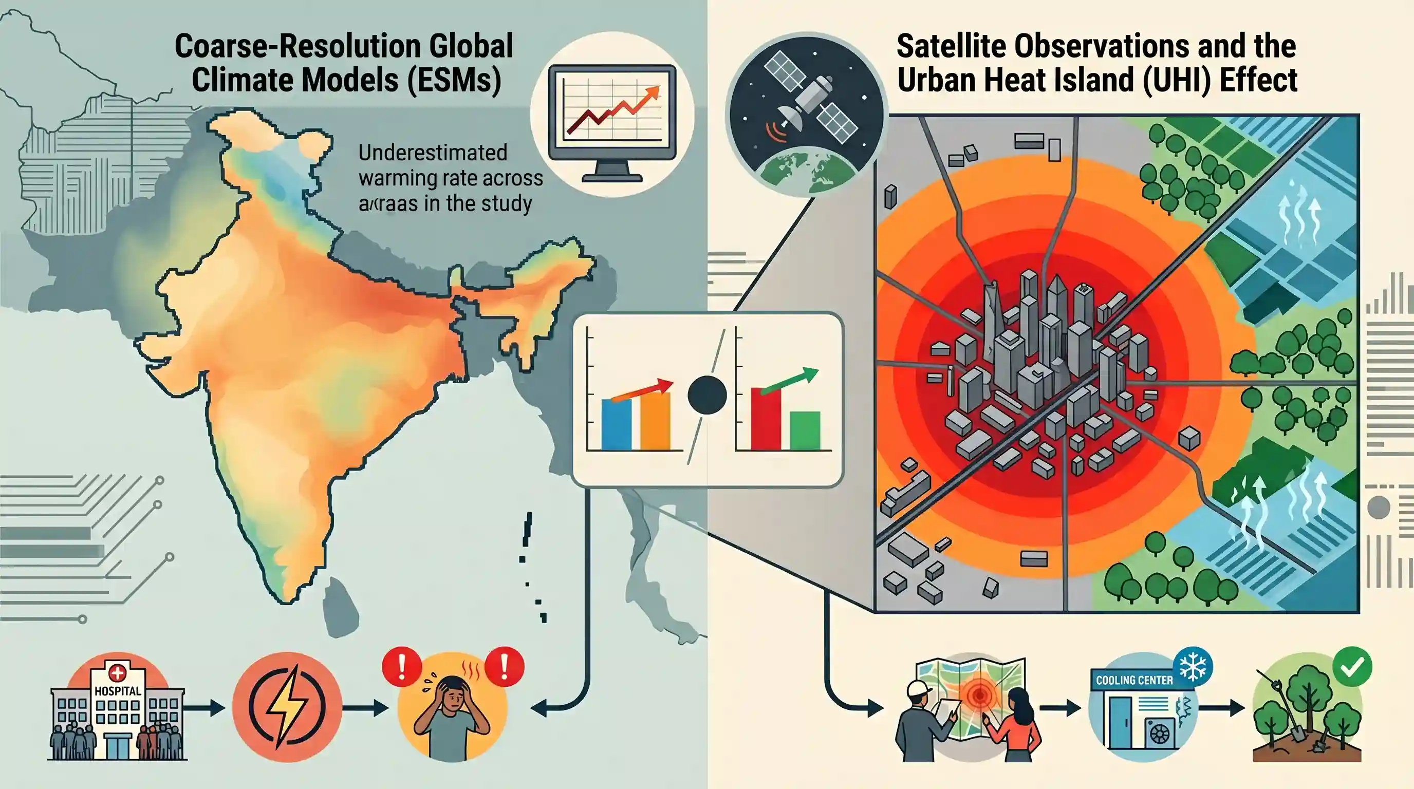
A recent study highlights that global climate models, such as Earth System Models (ESMs), significantly underestimate the rate at which Indian cities are warming compared to rural areas. While satellite data shows urban areas warming by 0.37°C per decade, coarse-resolution climate models fail to capture this divergence because they blend city and rural data into large grid cells. This masks the localized Urban Heat Island (UHI) effect, which is driven by heat-absorbing impervious surfaces in cities contrasting with the cooling evapotranspiration of rural vegetation. Consequently, relying on these generalized global models can lead to inadequate urban Heat Action Plans, underestimating the severe public health and energy risks posed by extreme urban heatwaves.
Key Points
- Satellite data reveals Indian urban areas are warming at 0.37°C per decade, significantly faster than the 0.26°C per decade observed in surrounding rural areas.
- Global Earth System Models (ESMs), such as those in CMIP6, severely underestimate this urban-rural temperature divergence due to their coarse spatial resolution, which averages out extreme localized urban heat.
- The Urban Heat Island (UHI) effect is primarily driven by the replacement of natural vegetation (which provides cooling via evapotranspiration) with heat-absorbing impervious surfaces like concrete and asphalt.
- Underestimating urban warming in climate projections compromises the effectiveness of local Heat Action Plans (HAPs), leaving city dwellers highly vulnerable to severe heatwaves and dangerous wet-bulb temperatures.
- Researchers emphasize the need for dynamic downscaling of climate models to better incorporate urban physics and accurately predict city-level microclimates.
Important Terms
Urban Heat Island (UHI) Effect

A phenomenon where urban areas experience significantly higher temperatures than surrounding rural regions due to heat-trapping surfaces like concrete and lack of vegetation.
UPSC context
GS Paper I (Geography/Urbanization) and GS Paper III (Environment); focuses on climate adaptation in Indian cities.
Heat Action Plans (HAPs)
Localized policy frameworks in India designed to mitigate heatwave impacts through early warning systems, public awareness, and emergency healthcare preparedness.
UPSC context
GS Paper III (Disaster Management); essential for assessing India's response to extreme weather events.
Earth System Models (ESMs)
Advanced climate models that simulate complex interactions between the atmosphere, ocean, land, ice, and biosphere to provide holistic global climate projections.
UPSC context
GS Paper III (Science & Technology/Environment); relevant for understanding the technical basis of climate change forecasting.
Coupled Model Intercomparison Project (CMIP)
A global collaborative framework that standardizes climate model experiments to ensure consistency and improve the reliability of international climate assessments like the IPCC reports.
UPSC context
GS Paper III (Environment/International Relations); tests knowledge of global climate governance and scientific standards.
Evapotranspiration
The combined process of water evaporating from surfaces and being released by plants, which provides a natural cooling effect in rural areas.
UPSC context
GS Paper I (Geography); critical for understanding the hydrological cycle and localized urban cooling strategies.
Prelims Trap
Urban Heat Island (UHI) effect is primarily driven by high localized greenhouse gas emissions in cities.
UHI is primarily driven by structural land-use changes (heat-absorbing concrete, loss of cooling vegetation and evapotranspiration), not localized greenhouse gas emissions or vehicular pollution.
Static Concepts Connected
What are the primary biophysical and structural drivers of the Urban Heat Island (UHI) effect?
- Albedo reduction: Dark surfaces like asphalt and concrete absorb significantly more solar radiation compared to lighter natural landscapes, storing heat.
- Evapotranspiration loss: Replacing natural vegetation with impervious surfaces eliminates the natural cooling effect of moisture released by plants.
- Urban canyon effect: Dense, tall building clusters trap thermal radiation and block natural wind flows, preventing convective cooling.
- Anthropogenic heat: Waste heat emitted from vehicle exhausts, air conditioning units, and industrial processes raises local ambient temperatures.
What is 'wet-bulb temperature' and why is it critical for assessing human heat stress?
- Definition: The lowest temperature air can reach via water evaporation. It evaluates both ambient heat and humidity simultaneously.
- Survivability threshold: At a wet-bulb temperature of 35°C, human sweat cannot evaporate, leading to fatal hyperthermia even in healthy adults.
- Measurement mechanism: Measured using a thermometer covered in a water-soaked cloth. In 100% humidity, wet-bulb temperature equals dry-bulb (actual) temperature.
Cross-Topic Patterns
Urban Heat & NDMA Heat Action Plans
UHI bridges GS1 Geography and GS3 Disaster Management. Flawed climate models lead to poorly localized Heat Action Plans, directly impacting urban resilience, public health, and Smart City infrastructure design.
Dynamic Downscaling & Monsoon Forecasting
The concept of 'dynamic downscaling' links global models (like CMIP6) to local microclimates. Watch for this in GS3 Science & Tech alongside India's supercomputing upgrades for better IMD forecasts.

Expect a 2026 prelims question linking UHI mechanisms (albedo/evapotranspiration) with human survivability limits (wet-bulb temperature).
Linked PYQs · 2
Linked PYQs · 2
- 2013MainsGS1
Bring out the causes for the formation of heat islands in the urban habitat of the world.
- 2025PrelimsGS1
The World Bank warned that India could become one of the first places where wet-bulb temperatures routinely exceed 35 °C. Which of the following statements best reflect(s) the implication of the above-said report? I. Peninsular India will most likely suffer from flooding, tropical cyclones and droughts. II. The survival of animals including humans will be affected as shedding of their body heat through perspiration becomes difficult. Select the correct answer using the code given below.
