Aravalli range degradation and desertification trends in India
Source:Indian Express ↗
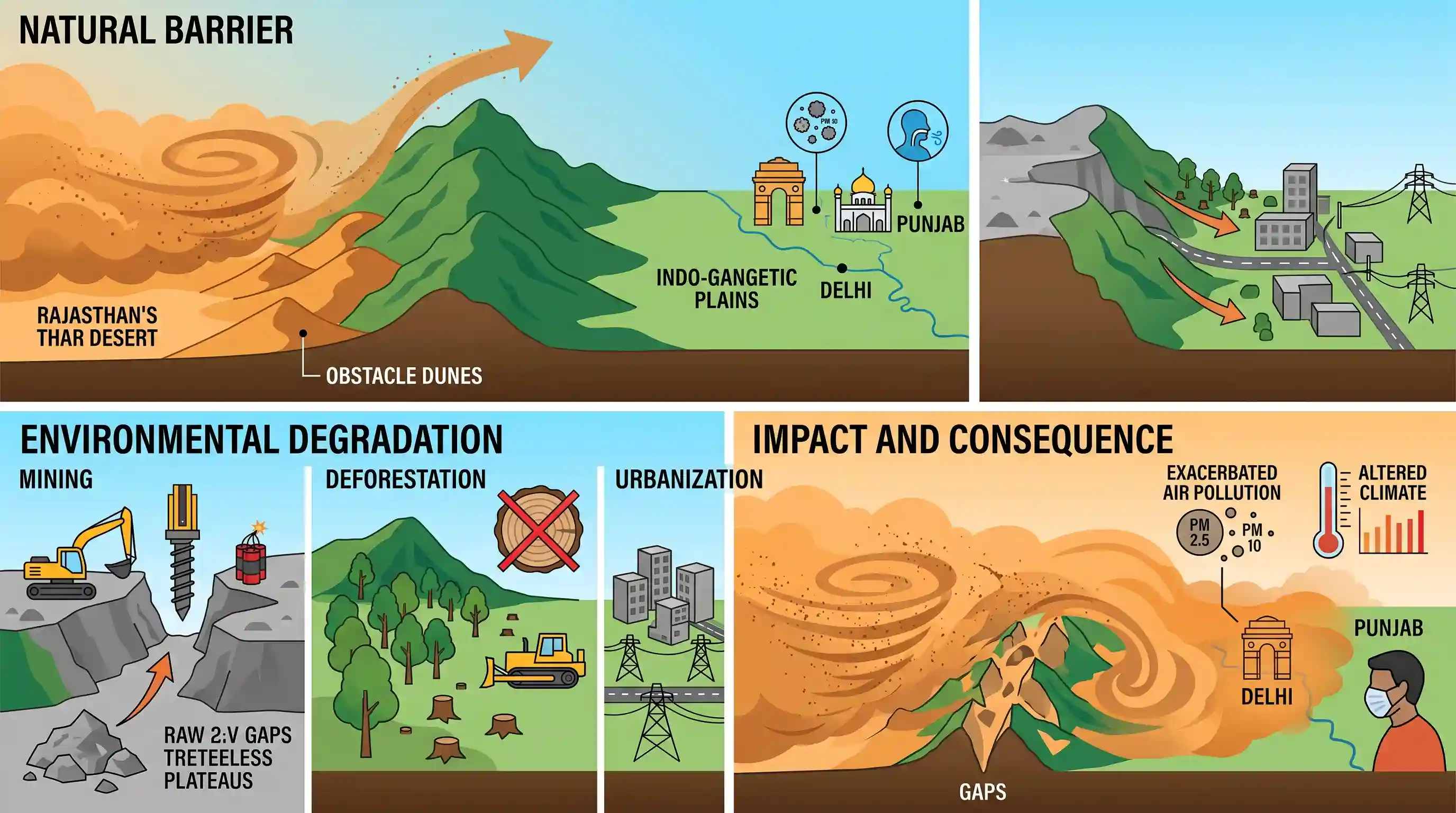
Why It Matters
The Aravalli range is India's primary defense against the eastward expansion of the Thar Desert and associated dust pollution. Understanding the ecological and climatic function of this mountain range, alongside the consequences of its anthropogenic degradation, is crucial for framing sustainable mining, environmental conservation, and air quality policies in Northern India.
Summary
Recent massive dust storms in Rajasthan highlight the critical but weakening role of the Aravalli range in protecting the Indo-Gangetic plains from desert dust. The Aravallis naturally intercept sand through 'obstacle dunes', but severe environmental degradation driven by mining, deforestation, and urbanization has compromised this shield. As hills disappear and gaps in the range widen, dust storms are increasingly penetrating into northern states like Delhi and Punjab, exacerbating air pollution and potentially altering local climate and temperature patterns.
Key Points
- The Aravalli range acts as a crucial natural barrier, intercepting dust-bearing winds from the Thar Desert and the Middle East through 'obstacle dunes' and vegetation to protect the Indo-Gangetic plains.
- Anthropogenic pressures, including mining for minor minerals, deforestation, and urbanization, have severely degraded the Aravallis, with a 2018 Forest Survey of India assessment noting the disappearance of 31 out of 128 hills in Rajasthan.
- A widely cited 2009 Wildlife Institute of India study identified 12 expanding gaps in the Aravalli range due to inadequate forest cover.
- The degradation allows dust storms to reach northern plains like Delhi even at lower wind speeds (35-40 kmph), posing significant threats to air quality, surface temperatures, and regional rainfall patterns.
Important Terms
Aravalli restoration framework

A policy roadmap by the Environment Ministry to revive the Aravalli ecosystem. It identifies causes of degradation—mining, urbanization, and deforestation—and proposes nature-based solutions to restore the range's role as a desertification barrier.
UPSC context
GS Paper III (Environment): Important for questions on land degradation, desertification control, and ecological restoration policies.
Forest Survey of India (FSI)
A premier organization under the Environment Ministry responsible for assessing India's forest cover. It recently mapped Aravalli hills to define legal protection zones based on elevation and slope criteria.
UPSC context
GS Paper III: Vital for forest management, conservation data, and the biennial State of Forest Report (ISFR).
Wildlife Institute of India (WII)
An autonomous institution under the Environment Ministry. It conducted a landmark 2009 study identifying 12 critical gaps in the Aravalli range that facilitate the eastward drift of the Thar Desert.
UPSC context
GS Paper III: Central to wildlife conservation, corridor mapping, and biodiversity impact assessments in mountain ecosystems.
India Meteorological Department (IMD)
The principal government agency responsible for meteorological observations and weather forecasting. It monitors the frequency and intensity of dust storms (Andhi) and their penetration into the Indo-Gangetic plains.
UPSC context
GS Paper I (Physical Geography): Key for climatology, monsoons, and natural disaster management topics.
Environment Ministry
The nodal central authority for planning and implementing environmental policies. It oversees the 'Aravalli Green Wall Project' to create a 1,400km buffer belt against desert expansion.
UPSC context
GS Paper II (Governance): The primary executive body for environmental legislation and international climate commitments (LDN).
Centre for Ecology Development and Research (CEDAR)
A non-profit research organization focused on mountain ecology and water resources. Its experts provided the scientific basis for how 'obstacle dunes' and vegetation in the Aravallis filter desert dust.
UPSC context
GS Paper III: Example of a research-based stakeholder contributing to ecological data and community-led restoration models.
Prelims Trap
"Obstacle dunes naturally form on the leeward side of the Aravalli range to trap desert sand."
Obstacle dunes form on the windward (western) slopes, not leeward. Sand-bearing winds from the Thar drop their load upon hitting the barrier. UPSC frequently flips windward/leeward mechanics.
Static Concepts Connected
What is the geological and climatic significance of the Aravalli Range?
- Relict Mountains: They are one of the oldest fold mountain systems globally, now heavily eroded into residual (relict) mountains.
- Climatic Divide: They act as a crucial physical barrier that prevents the eastward expansion of the Thar Desert into the fertile Indo-Gangetic plains.
- Monsoon Alignment: They run parallel to the Arabian Sea branch of the South-West Monsoon, offering no obstruction, which causes low rainfall in Rajasthan.
How do aeolian (wind-driven) processes shape desert margins like the Thar?
- Wind Deflation: Wind acts as an erosional agent, removing loose sand and dust from the desert surface, which can be transported hundreds of kilometers to cities like Delhi.
- Obstacle Dunes: These form when sand-carrying winds encounter a topographic barrier (like the Aravallis), losing velocity and forcing sand deposition on the windward slopes.
- Suspension Load: Fine dust is carried high into the atmosphere, which alters local surface albedo, increases particulate pollution, and can suppress regional rainfall.
Cross-Topic Patterns
Aravalli Green Wall & UNCCD commitments
India's Aravalli Green Wall Project mimics Africa's Great Green Wall in the Sahel region, explicitly connecting domestic afforestation and barrier-creation efforts to India's UNCCD COP14 targets for combating desertification.
Geomorphology meets Urban Air Pollution
The loss of physical geographic barriers (Aravalli hills) directly exacerbates urban PM10/PM2.5 pollution in the National Capital Region (NCR), linking geomorphology directly to urban public health crises.

Expect a multi-statement prelims question in 2026 linking Aravalli structural gaps, obstacle dunes, and changing NCR pollution patterns.
Linked PYQs · 5
Linked PYQs · 5
- 2020MainsGS1
The process of desertification does not have climatic boundaries. Justify with examples.
- 2021MainsGS1
Briefly mention the alignment of major mountain ranges of the world and explain their impact on local weather conditions, with examples.
- 2020MainsGS1
Examine the status of forest resources of India and its resultant impact on climate change.
- 2025MainsGS3
Mineral resources are fundamental to the country's economy and these are exploited by mining. Why is mining considered an environmental hazard? Explain the remedial measures required to reduce the environmental hazard due to mining.
- 2024MainsGS3
Industrial pollution of river water is a significant environmental issue in India. Discuss the various mitigation measures to deal with this problem and also the government's initiatives in this regard.
