Gandak River Water Level: Bihar Disaster Preparedness for Flash Floods
Source:newsonair ↗
Why It Matters
Flooding is a recurrent and devastating geographical challenge for North Bihar, primarily driven by rivers originating in the Himalayas of Nepal. Understanding the courses of these rivers (like the Gandak/Narayani) and the specific districts they impact is a staple of BPSC Geography and Disaster Management syllabus.
Summary
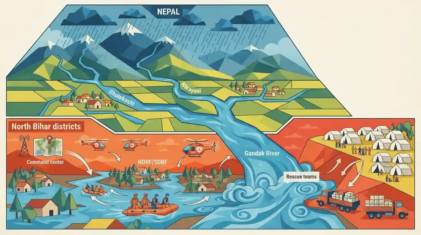
Bihar and Uttar Pradesh are heightening disaster preparedness due to the threat of rising river water levels following severe flash floods in Nepal. Triggered by heavy rainfall in the catchments of Nepal's Bhotekoshi and Narayani rivers, downstream rivers in India, particularly the Gandak River, are expected to swell. The Bihar government has placed multiple North Bihar districts on high alert and deployed NDRF/SDRF teams to mitigate potential flood damage.
Key Points
- Flash floods in Nepal's Bhotekoshi and Narayani rivers threaten to increase water levels in downstream Indian rivers.
- The Gandak River (known as Narayani in Nepal) poses a major flood risk to districts in North Bihar.
- Bihar districts including West Champaran, East Champaran, Gopalganj, Saran, Muzaffarpur, and Vaishali have been placed on high alert.
- Uttar Pradesh districts bordering Nepal, such as Maharajganj and Kushinagar, are also heightening preparedness.
- NDRF and SDRF teams have been deployed to vulnerable regions to handle potential emergencies and rescue operations.
Important Terms
National Disaster Response Force (NDRF)

A specialized central contingency force deployed to conduct swift search, rescue, and relief operations during natural or human-induced disasters, such as floods and earthquakes.
UPSC context
Crucial for GS Paper 2 (Disaster Management); tests knowledge of central-state coordination and emergency response mechanisms during Bihar floods.
State Disaster Response Force (SDRF)
A dedicated state-level force responsible for immediate disaster response, search, rescue, and evacuation operations during emergencies like the perennial North Bihar floods.
UPSC context
Vital for GS Paper 2 (Disaster Management). Highlights Bihar's localized institutional capacity and preparedness for tackling frequent natural calamities.
Disaster Management Department (Bihar)
The nodal agency of the Bihar government tasked with formulating policies, executing disaster prevention, mitigation, and leading relief and rehabilitation efforts statewide.
UPSC context
Important for GS Paper 2 (Polity/Disaster Management). Evaluates understanding of state administrative machinery addressing Bihar's extreme flood vulnerability.
Water Resources Department (Bihar)
The state department responsible for managing irrigation, flood control infrastructure, embankment maintenance, and operating the Flood Management Information System for river basins.
UPSC context
Key for GS Paper 2 (Geography & Economy of Bihar). Covers water infrastructure, interstate river sharing, and structural flood control strategies.
Valmiki Tiger Reserve (VTR)
Bihar's only tiger reserve, situated in West Champaran along the Gandak River. It features a unique combination of Bhabar and Terai landscapes.
UPSC context
Essential for Prelims and GS Paper 1/2 (Geography/Environment). Tests knowledge of Bihar's protected areas, biodiversity, and border geography.
Prelims Trap
The river triggering alerts in West Champaran and Gopalganj is known as the Bhotekoshi in Nepal.
Bhotekoshi is part of the Kosi river basin, not the Gandak. The Gandak is known as the Narayani (or Kali Gandaki) in Nepal.
Static Concepts Connected
What is the geographical course of the Gandak River in Bihar?
- Origin & Entry: Known as Narayani/Kali Gandaki in Nepal, it enters Bihar at Valmikinagar in the West Champaran district.
- Course & Boundary: Flows southward, acting as a natural boundary between UP and Bihar, draining districts like West Champaran, Gopalganj, Saran, and Vaishali.
- Ganga Confluence: It meets the River Ganga at Pahleja Ghat near Sonepur, directly across from Patna.
What is the institutional setup for flood disaster response in Bihar?
- Apex Body: The Bihar State Disaster Management Authority (BSDMA), chaired by the Chief Minister, is the apex body for policy and coordination.
- Operational Forces: National Disaster Response Force (NDRF) and State Disaster Response Force (SDRF) battalions are pre-positioned in vulnerable districts during monsoons.
- Early Warning: The Water Resources Department (WRD) monitors river gauges and integrates catchment data from Nepal to issue downstream alerts.
Cross-Topic Patterns
India-Nepal hydro-diplomacy and floods
Management of the Gandak and Kosi barrages routinely tests bilateral ties, directly linking state-level disaster mitigation to India-Nepal International Relations in Mains GS Paper 1.
North Bihar floods and cropping patterns
North Bihar's recurrent inundation severely impacts Kharif crops, driving a strategic shift towards wetland agriculture (like Makhana and aquaculture), a key theme in GS Paper 2 Economy.

Expect map-based prelims questions matching North Bihar rivers (Gandak, Kosi, Kamla) with their Nepal names and Bihar entry districts.
Linked PYQs · 3
Linked PYQs · 3
- 2023BPSC_PRELIMSGS1
The other name of river Gandak is
- 2011BPSC_PRELIMSGS1
North Bihar is famous for:
- 2020BPSC_PRELIMSGS1
Which of the following rivers flowing in Bihar is a north flowing river?
