Nepal Border Barrier Lake Overflow Triggers Bihar Flood Alert
Source:etv-bharat ↗
Why It Matters
This event highlights the transboundary nature of flood disasters in Bihar, the geological vulnerability of the Himalayan region, and the critical role of the Valmikinagar barrage in flood and silt management. Understanding these dynamics is essential for disaster preparedness and physical geography sections of the BPSC and civil services examinations.
Summary
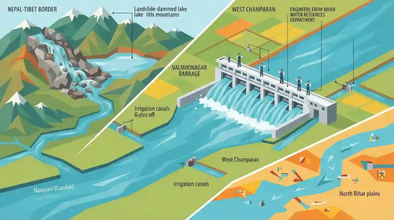
Bihar has issued a code-red alert following reports of an overflowing and subsiding landslide-induced barrier lake on the Nepal-Tibet border. Formed at the confluence of the Chhochen Khola and Purepu Tsangpo rivers, the lake is releasing fresh floodwaters flowing down the Trishuli and Narayani (Gandak) rivers toward India. The Bihar Water Resources Department (WRD) has deployed engineers at the Valmikinagar barrage in West Champaran. All 36 gates of the barrage are currently open to manage the rising water discharge, while irrigation canals have been closed to prevent silt choking.
Key Points
- A critical code-red alert was sounded in Bihar due to a barrier lake formed on the Tibet-Nepal border overflowing and subsiding, releasing floodwaters towards India.
- The landslide dam/barrier lake was created at the confluence of Chhochen Khola and Purepu Tsangpo rivers along the Tibet-Nepal border following a devastating deluge in Nepal.
- The floodwaters travel approximately 300 km from the upper Himalayan reaches to India via the Trishuli and Narayani (Gandak) rivers in just a few hours.
- Bihar WRD officials are on high alert at the Valmikinagar barrage in West Champaran, which is the first point of floodwater entry into Bihar.
- All 36 gates of the Valmikinagar barrage (built in 1968-69 and designed to withstand 8.5 lakh cusecs) are fully open; canals have been closed to prevent choking from heavy silt.
Important Terms
Bihar Water Resources Department (WRD)

The nodal agency of the Bihar government responsible for planning, construction, and maintenance of water resource schemes, flood control infrastructure, drainage systems, and irrigation projects across the state.
UPSC context
BPSC GS Paper II (Geography & Disaster Management) — tests administrative response to recurrent floods and state water resources.
Landslide Dam Burst Flood (LDBF)
A sudden, catastrophic downstream deluge caused by the failure or breaching of a natural barrier formed when landslides, avalanches, or seismic debris block a river's course.
UPSC context
BPSC GS Paper II (Disaster Management) — tests knowledge of transboundary natural hazards, flash flood risks, and mitigation strategies.
Valmikinagar Barrage
A critical transboundary water-control structure built on the Gandak River at the Indo-Nepal border in West Champaran, Bihar, used to regulate river discharge and feed local irrigation canals.
UPSC context
BPSC GS Paper II (Geography of Bihar) — tests state infrastructure, water management, and Indo-Nepal transboundary river cooperation.
Gandak River (Narayani)
A major left-bank tributary of the Ganga, originating in the Nepal Himalayas (known as Narayani), which is critical for irrigation and presents significant flood challenges in northern Bihar.
UPSC context
BPSC GS Paper II (Physical Geography of Bihar) — tests river basins, drainage networks, and water resource utilization.
Kosi-Mechi Link Project
An intra-state river interlinking project in Bihar designed to divert excess water from the Kosi River to the Mechi River, providing irrigation and mitigating floods in the Seemanchal region.
UPSC context
BPSC GS Paper II (Geography & Economy of Bihar) — tests developmental planning, river interlinking, and flood prevention schemes.
Prelims Trap
The historic Triveni Canal, which irrigates East and West Champaran, originates from the Kosi River basin.
Aspirants often confuse the irrigation systems of North Bihar, wrongly identifying the historic Triveni Canal as originating from the Kosi or Sone river rather than the Gandak River at Valmikinagar.
Static Concepts Connected
What is the historical and geographical significance of the Gandak River in Bihar?
- Ancient Vedic Identity: Known as 'Sadanira' (ever-flowing water) in the Satapatha Brahmana, it historically marked the boundary between the Kosala and Videha kingdoms.
- Course in Bihar: Enters the plains of Bihar at Valmikinagar (West Champaran) and joins the Ganga at Sonpur (near Patna).
- Tributaries & Names: It is fed by the Trishuli and Budhi Gandak headwaters in Nepal, and is known as the Narayani River across the border.
How do Landslide Dam Outburst Floods (LDOFs) differ from Glacial Lake Outburst Floods (GLOFs)?
- Triggering Mechanism: LDOFs are triggered by landslide debris blocking a river channel, whereas GLOFs are caused by the failure of unstable moraine dams containing glacial meltwater.
- Warning Window: Landslide dams are highly unstable and can fail within hours of formation, leaving almost no warning time compared to monitored GLOF lakes.
- Sediment Load: LDOFs carry exceptionally high mud and sediment loads (siltation) which can instantly choke downstream barrages and irrigation canals.
Cross-Topic Patterns
Sadanira: Ancient boundary to modern hazard
The Gandak (Sadanira), which defined Videha's western boundary in the Satapatha Brahmana, remains North Bihar's primary transboundary hazard conduit, linking ancient settlement geography to modern disaster vulnerability.
Bilateral hydro-diplomacy and Bihar agriculture
The 1959 Gandak Project Agreement between India and Nepal governs the Valmikinagar Barrage, demonstrating how transboundary hydro-diplomacy directly determines agricultural security in the Champaran plains.

Questions linking Gandak's Vedic name (Sadanira), Valmikinagar barrage treaty, and West Champaran's physical geography are highly probable.
Linked PYQs · 4
Linked PYQs · 4
- 2023BPSC_PRELIMSGS1
The other name of river Gandak is
- 2025BPSC_PRELIMSGS1
Which of the following parks/sanctuaries come under the project tiger in Bihar?
- 2020BPSC_PRELIMSGS1
Which of the following rivers flowing in Bihar is a north flowing river?
- 2023BPSC_PRELIMSGS1
Bihar’s geographical structure consists of rock systems. Match the rock systems with their descriptions: a. Dharwar rock system 1. Created by the rapid deposition of alluvium by Himalayan and Peninsular rivers b. Vindhyan rock system 2. Can be found in the West Champaran district c. Quaternary rock system 3. Part of the oldest Archaean rock system d. Tertiary rock system 4. Sandstone, limestone, dolomite, quartzite and shale are the main constituents of this rock system Select the correct answer using the codes given below.
