Flood Management: Bihar implements river linking and barrage projects
Source:etvbharat ↗
Why It Matters
Annual flooding is the single most persistent geographic and economic challenge for North Bihar. Questions on major projects like Kosi-Mechi, international barrages, and key physical drainage aspects of the state are heavily prioritized in BPSC Prelims and Mains GS papers.
Summary
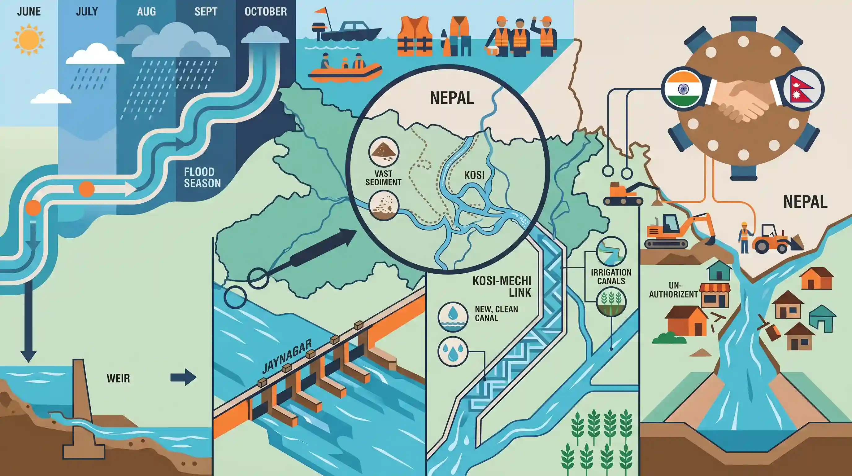
The article outlines Bihar's intensive preparation for managing its annual flood season (June 1–October 31). It details crucial infrastructure initiatives like the Kosi-Mechi River Linking Project and the Kamala river weir-to-barrage conversion at Jaynagar to manage floodwaters and extend irrigation. It highlights the Kosi River's massive morphological changes and the key outcomes of the March 15, 2026 Indo-Nepal Joint Committee meeting on the Kosi and Gandak Projects, where Nepal agreed to free critical flood management channels from encroachments within its jurisdiction.
Key Points
- Flood Season & Vulnerability: Bihar's flood season officially spans from June 1 to October 31. Out of the 38 districts in Bihar, 28 are flood-prone, with 21 districts in North Bihar and 15 districts overall identified as the most heavily affected. Flooding in North Bihar is driven by heavy rainfall in Nepal, while South Bihar's flooding is influenced by rainfall in Jharkhand.
- Kosi-Mechi River Linking Project: Designed to irrigate drought-prone areas in Seemanchal and alleviate flooding. It links the Kosi River to the Mechi River (a tributary of the Mahananda River). The total project length is 117.50 km, which incorporates the 41.30 km Eastern Kosi Main Canal. Key components include 9 canal siphons, 28 head regulators, 14 siphon aqueducts, 42 road bridges, 9 pipe culverts, and 9 cross regulators. The funding is shared 60% by the Center and 40% by the State. The primary beneficiary districts are Araria, Purnea, Kishanganj, and Katihar.
- Kamala Balan & Saran Canal Upgrades: The weir on the Kamala River at Jaynagar (Madhubani district) is being converted into a barrage to provide irrigation to 45,000 hectares in eight blocks. Concurrently, a Rs 1,150 crore project is restoring the Saran main canal's distribution system.
- Kosi River Morphological Changes: As the 'Sorrow of Bihar', the Kosi River's inundation area increased from 815.12 sq km in 2015 to 5,503.65 sq km in 2020, as per ISRO studies. The river has shifted its course by over 120 km over 2,500 years. To restore its path near the Veerpur Barrage, the Water Resources Department is constructing a 2.5 km long channel.
- Indo-Nepal Cooperation: The 11th meeting of the Joint Committee on the Kosi and Gandak Projects was held on March 15, 2026, co-chaired by Santosh Kumar Malla (Bihar) and Mitra Baral (Nepal). Nepal agreed to clear encroachments along a 35 km stretch within its territory encompassing critical canals, embankments, and barrages.
Important Terms
Kosi-Mechi River Linking Project

India's second major river-linking project, transferring surplus water from the Kosi River to the Mechi River (Mahananda tributary) to expand irrigation across northeastern Bihar and mitigate regional flood and drought risks.
UPSC context
GS Paper I (Geography) & GS Paper III (Disaster Management). Tests inter-basin water transfer and drought-mitigation concepts.
Kosi Project
A major bilateral flood control, irrigation, and power initiative between India and Nepal established via the 1954 Kosi Agreement, featuring the Kosi Barrage at Bhimnagar to regulate the highly volatile Kosi River.
UPSC context
GS Paper II (International Relations) & GS Paper III (Disaster Management). Tests transboundary water governance.
Gandak Project
A joint irrigation and power project between India and Nepal based on the 1959 Gandak Agreement, utilizing the Valmikinagar Barrage to irrigate massive agricultural tracts in Bihar, Uttar Pradesh, and Nepal.
UPSC context
GS Paper II (International Relations) & GS Paper III (Agriculture). Tests cooperative cross-border water sharing.
Kamala Balan Weir-to-Barrage Conversion Scheme
An infrastructure project in Madhubani, Bihar, converting the legacy 1974 Kamala River weir at Jaynagar into a modern, automated barrage to double irrigation potential and strengthen flood defense in Mithilanchal.
UPSC context
GS Paper III (Disaster Management). Tests localized flood-adaptation infrastructure and irrigation modernization.
Saran Canal Restoration Project
A water resource initiative focused on desilting and reconstructing the Saran main and branch canals in Bihar to restore optimal irrigation capacity to farmers in Gopalganj, Saran, and Siwan districts.
UPSC context
GS Paper III (Agriculture & Irrigation). Tests legacy canal rehabilitation and tail-end water delivery.
Prelims Trap
The Kosi-Mechi project is India's second approved inter-state river linking project.
The Kosi-Mechi link is an *intra-state* project located entirely within Bihar, unlike the Ken-Betwa project which is *inter-state* (spanning MP and UP).
Static Concepts Connected
What geomorphological factors cause the Kosi River to frequently shift its course?
- High sediment load: The Kosi carries one of the highest sediment yields globally, sourced from the young and easily erodible Himalayan geological formations.
- Silted riverbeds: Heavy silt deposition raises the riverbed over time, making the channel unstable and forcing the river to break its banks.
- Sudden gradient drop: Exiting the steep Himalayan foothills into the flat plains causes a sharp drop in water velocity, triggering rapid sediment deposition and channel avulsion.
What are the key bilateral treaties governing India-Nepal water cooperation?
- Kosi Agreement (1954): Signed to construct the Kosi barrage; amended in 1966 to address Nepalese concerns regarding sovereignty and water-use rights.
- Gandak Agreement (1959): Governs the construction of the Gandak Barrage for irrigation and power generation, benefiting both Bihar and Nepal; amended in 1964.
- Mahakali Treaty (1996): An agreement for the integrated development of the Mahakali River, encompassing the long-delayed Pancheshwar Multipurpose Project.
Cross-Topic Patterns
River-linking and cooperative federalism
The 60:40 central funding ratio for Kosi-Mechi highlights how state-level climate adaptation projects rely heavily on central fiscal clearance, intersecting with constitutional divisions of power on water.
Hydro-diplomacy and neighborhood-first policy
Transboundary flood management between Bihar and Nepal highlights how local disaster mitigation relies on bilateral institutions like the Joint Committee on Kosi and Gandak Projects.

UPSC may frame a 2026 question linking Kosi-Mechi's intra-state status, Mahananda basin geography, and India-Nepal joint committees.
Linked PYQs · 4
Linked PYQs · 4
- 2025BPSC_PRELIMSGS1
Which districts in Bihar will benefit from the Kosi Mechi Link Project?
- 2024-IBPSC_PRELIMSGS1
Which river is known as the ‘Sorrow of Bihar’?
- 2020BPSC_PRELIMSGS1
Which of the following rivers flowing in Bihar is a north flowing river?
- 2023BPSC_PRELIMSGS1
The average height of the Kosi plain from mean sea level is
