Gandak River Water Level and Flood Management in North Bihar
Source:ani ↗
Why It Matters
Understanding the dynamics of transboundary rivers like the Gandak and the role of infrastructure such as the Valmikinagar Barrage is critical for BPSC Prelims geography, as the state is highly prone to floods originating from Nepalese river catchments.
Summary
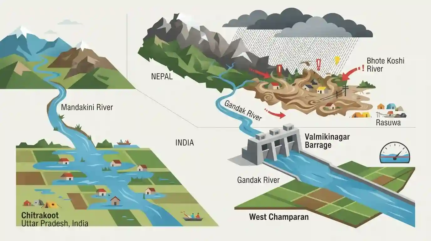
The water level of the Gandak River in West Champaran, Bihar, is experiencing fluctuations due to severe flood situations in Nepal but remains below the danger mark, with the Valmikinagar Barrage recording a discharge of 1,14,000 cusecs. Meanwhile, the Mandakini River has caused low-lying inundation in Chitrakoot, Uttar Pradesh, and Nepal continues to face catastrophic devastation from the Rasuwa Bhote Koshi flash floods.
Key Points
- The water level of the Gandak River in Bihar's West Champaran is experiencing continuous fluctuations due to heavy discharge from catchment areas in flood-hit Nepal, though it remains below the danger mark.
- The discharge level at the Valmikinagar Barrage, located in West Champaran, is currently recorded at 1,14,000 cusecs, with continuous monitoring by irrigation and flood-control officials.
- In Uttar Pradesh, Chitrakoot is on alert after the Mandakini River rose significantly, causing flood-like conditions in low-lying areas, including Ram Ghat and Nirmohi Akhada; police are using drone surveillance to manage the situation.
- Nepal has suffered catastrophic flash floods, particularly the Rasuwa Bhote Koshi deluge, resulting in 675 deaths and leaving over 2,418 people missing, according to Nepal's National Disaster Risk Reduction and Management Authority (NDRRMA).
- The Gandak River, also known as the Narayani in Nepal, is a major Himalayan tributary that enters Bihar through the West Champaran district and feeds the historic Triveni Canal irrigation system.
Important Terms
Triveni Canal system

An irrigation canal system in Bihar's West Champaran district, fed by the Gandak River at Valmikinagar. It provides crucial irrigation to northwestern Bihar and parts of Uttar Pradesh under the Indo-Nepal Gandak Project.
UPSC context
BPSC GS Paper II (Bihar Geography/Irrigation). Tests knowledge of northern Bihar's canal systems and regional agricultural lifelines.
Valmikinagar Barrage
A transboundary barrage constructed on the Gandak River on the India-Nepal border in West Champaran, Bihar. It regulates water flow, controls seasonal flooding, and diverts water into eastern and western canal systems.
UPSC context
BPSC GS Paper II (Bihar Geography and Disaster Management). Tests knowledge of flood control structures and transboundary river management.
Gandak River
A major transboundary river originating in Tibet/Nepal (known as Narayani) that joins the Ganga near Patna, Bihar. It acts as a major drainage and agricultural channel but is highly prone to seasonal flooding.
UPSC context
BPSC GS Paper II (Bihar Geography). Tests comprehension of the Himalayan drainage system, river basins, and flood patterns.
National Disaster Risk Reduction and Management Authority (NDRRMA) of Nepal
The apex executive body of Nepal responsible for disaster management, rescue operations, and early warning systems. It plays a critical role in managing glacial collapses and transboundary flash floods that affect Bihar downstream.
UPSC context
BPSC GS Paper II (Disaster Management / International Relations). Tests understanding of transboundary disaster cooperation and river basin management.
Mandakini River (Chitrakoot)
A tributary of the Yamuna River (also called Paisuani) originating in Madhya Pradesh and flowing through Chitrakoot, Uttar Pradesh. It is a critical cultural and hydrological lifeline prone to flash floods in Bundelkhand.
UPSC context
BPSC GS Paper II (Indian Geography). Tests conceptual clarity regarding peninsular river tributaries and regional water resources in central India.
Chitrakoot Police
The local law enforcement agency of Chitrakoot (Uttar Pradesh), responsible for public safety, crowd control, drone surveillance, and coordination with NDRF/SDRF teams during seasonal floods of the Mandakini River.
UPSC context
BPSC GS Paper II (Governance & Disaster Management). Tests understanding of ground-level administrative machinery and technology in flood disaster response.
Prelims Trap
The historic Triveni Canal, which irrigates North-West Bihar, is a major component of the Kosi River Project.
The Triveni Canal is often confused with the Kosi Project canals due to its location in North Bihar. It is exclusively drawn from the Gandak River at Valmikinagar.
Static Concepts Connected
What is the geographical course and historical significance of the Gandak River?
- Origin and Names: Originated at the Nhubine Himal Glacier in Nepal's Mustang region, where it is known as the Narayani or Sapt Gandaki.
- Bihar Entry: Enters India at Valmikinagar in the West Champaran district of Bihar, flowing south-southeastward.
- Confluence: Merges with the Ganga River as a left-bank tributary near Sonpur (Harihar Kshetra) and Hajipur.
- Ancient Identity: Identified as 'Sadanira' in the Shatapatha Brahmana, historically marking the eastern boundary of Aryan expansion.
What are the main components of the Gandak Project?
- Bilateral Agreement: A joint multi-purpose river valley venture executed by India (Bihar and Uttar Pradesh) and Nepal.
- Valmikinagar Barrage: A 739-meter-long barrage built at Bhainsalotan (Valmikinagar) to regulate water release and generate power at Suratpura.
- Canal Networks: Feeds the historic Triveni Canal alongside the Tirhut (Eastern) and Saran (Western) canal systems.
Cross-Topic Patterns
Indo-Nepal Diplomacy & Flood Governance
Bihar's flood mitigation (Gandak, Kosi, and Bagmati systems) relies heavily on transboundary water-sharing treaties, joint barrage operations, and real-time hydrological data-sharing with Nepal.
Cryospheric Hazards & Downstream Inundation
Climate-induced glacial melt and GLOFs in high-altitude Nepalese catchments directly escalate flash-flood vulnerability in Bihar's downstream plains, demanding cross-border ecological monitoring.

Vedic identity (Sadanira) and canal networks (Triveni/Tirhut) of the Gandak are highly likely to merge into a single BPSC geography MCQ.
Linked PYQs · 4
Linked PYQs · 4
- 2023BPSC_PRELIMSGS1
The other name of river Gandak is
- 2020BPSC_PRELIMSGS1
Which of the following rivers flowing in Bihar is a north flowing river?
- 2016BPSC_PRELIMSGS1
Which of the following canal systems irrigate areas of Bihar?
- 2023BPSC_PRELIMSGS1
Bihar’s geographical structure consists of rock systems. Match the rock systems with their descriptions: a. Dharwar rock system 1. Created by the rapid deposition of alluvium by Himalayan and Peninsular rivers b. Vindhyan rock system 2. Can be found in the West Champaran district c. Quaternary rock system 3. Part of the oldest Archaean rock system d. Tertiary rock system 4. Sandstone, limestone, dolomite, quartzite and shale are the main constituents of this rock system Select the correct answer using the codes given below.
