Bihar Monsoon Rainfall Deficit and Transboundary Flood Causes
Source:Indian Express ↗
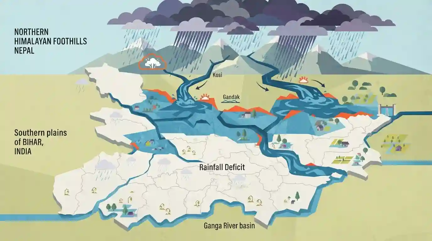
Why It Matters
Understanding the meteorological and hydrological causes of Bihar floods—specifically the role of Nepal rainfall and transboundary river dynamics—is essential for disaster management and geography sections of the BPSC examination.
Summary
The article examines the paradox of Bihar experiencing severe floods despite an overall rainfall deficit in parts of the state. It explains that heavy rainfall and cloudbursts in the Himalayan foothills and Nepal caused sudden, massive surges in transboundary rivers flowing into Bihar, such as the Kosi and Gandak, combined with swelling levels in the Ganga basin.
Key Points
- Bihar experienced a paradox of heavy floods despite facing an overall monsoon rainfall deficit in several districts.
- The flooding was largely triggered by heavy cloudbursts and intense precipitation in neighboring Nepal and the Himalayan foothills, causing sudden surges in transboundary rivers like the Kosi, Gandak, and Bagmati.
- The Ganga river basin experienced high cumulative water discharge due to heavy upper catchment rainfall, swelling water levels downstream in Bihar.
- Highlights the vulnerability of north Bihar plains to external catchment rainfall dynamics independent of local rain deficits.
Important Terms
India Meteorological Department (IMD)

The premier national agency under the Ministry of Earth Sciences responsible for meteorological observations, weather forecasting, and seismology in India.
UPSC context
BPSC Paper II / Geography & Disaster Management: Tests knowledge of weather monitoring, monsoon trends, and flood early warning systems in Bihar.
Nepal Meteorological Department
The national meteorological agency of Nepal that monitors weather patterns, issues forecasts, and tracks precipitation in Himalayan catchment areas that feed rivers flowing into northern Bihar.
UPSC context
BPSC Paper I/II / Bihar Geography & International Relations: Tests understanding of transboundary river basin management and hydro-meteorological data sharing between India and Nepal.
Static Concepts Connected
What are the key geographical features and northern tributaries of the Ganga river system in Bihar?
- Northern Tributaries: Originating rivers include the Kosi, Gandak, Bagmati, Burhi Gandak, and Kamla originating largely in the Himalayan and Nepal foothills.
- Flood Proneness: North Bihar plains suffer from chronic floods due to high silt load, steep slope transitions, and transboundary river surges.
Cross-Topic Patterns
Transboundary Rivers and Disaster Management Vulnerability
Bihar's flood vulnerability links river geography with disaster management protocols, emphasizing regional disaster resilience under NDMA guidelines.

Bihar flood paradox (local deficit vs transboundary surge) is a high-yield conceptual trap for BPSC Prelims statement questions.
Linked PYQs · 3
Linked PYQs · 3
- 2020BPSC_PRELIMSGS1
Which of the following rivers flowing in Bihar is a north flowing river?
- 2024-IBPSC_PRELIMSGS1
Which river is known as the ‘Sorrow of Bihar’?
- 2024-EBPSC_PRELIMSGS1
Which of the following drainage systems drains the lands of Bihar?
