Bihar Monsoon Paradox Occurs Due To Transboundary River Discharges
Source:Indian Express ↗
Why It Matters
Understanding the meteorological and hydrological causes of Bihar floods is essential for disaster management and geography questions in BPSC Prelims.
Summary
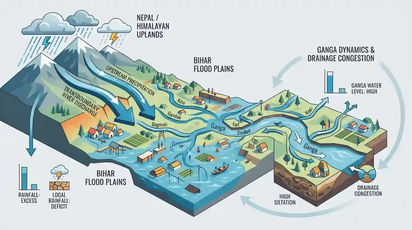
This article examines the paradox of Bihar facing severe floods despite an overall rainfall deficit, highlighting the critical role of transboundary river discharge from Nepal, heavy upstream precipitation, and Ganga river dynamics including high siltation and drainage congestion.
Key Points
- Bihar experienced a complex monsoon paradox with an overall state-level rainfall deficit alongside severe localized flooding.
- Floods in north Bihar are significantly influenced by heavy rainfall events in neighboring Nepal and water discharge patterns from transboundary rivers like the Kosi, Gandak, and Bagmati.
- The Ganga river's high siltation levels, backwater effects, and rising bed levels exacerbate inundation and drainage congestion across the plains of Bihar.
Important Terms
Nepal Transboundary Discharge

The phenomenon where heavy rainfall and rapid snowmelt in the Himalayan river catchments of Nepal cause massive transboundary water discharge into Bihar, triggering severe flooding regardless of local rainfall deficits.
UPSC context
BPSC Paper II (Geography / Disaster Management): Tests understanding of transboundary river management, Himalayan river systems (Kosi, Gandak), and flood vulnerabilities in Bihar.
Drainage Congestion and Backwater Effect
The blockage of natural drainage when a main river (like the Ganga) swells and backs up into its tributaries, preventing normal outflow and inundating adjacent low-lying areas.
UPSC context
BPSC Paper II (Geography / Physical Features): Essential for analyzing monsoon hydrology, river confluences, and atypical flood mechanisms in north and south Bihar plains.
Ganga River Basin Authorities
Institutional bodies and implementation arms, such as the National Mission for Clean Ganga (NMCG), tasked with holistic planning, pollution abatement, and environmental flow management across the river system.
UPSC context
BPSC Paper II (Polity & Governance / Environment): Tests knowledge of statutory river governance structures, inter-state basin management, and environmental policy frameworks.
Prelims Trap
An overall state-level rainfall deficit rules out the possibility of severe widespread flooding in Bihar.
Aspirants often assume that severe state-wide flooding requires a heavy surplus of local monsoon rainfall, ignoring the decisive role of upstream transboundary discharge from Nepal.
Static Concepts Connected
What are the primary geographical factors causing annual floods in North Bihar?
- Transboundary Discharge:: Himalayan Origin, High-velocity rivers originating in Nepal carry massive sediment loads and sudden discharge surges during monsoon.
- Structural Constraints:: Embankment Paradox, Decades of embankment construction have raised riverbeds above surrounding plains, causing severe drainage congestion and breaching risks.
- Ganga Siltation:: Ganga Backwater, High siltation and rising bed levels in the Ganga choke the drainage capacity of tributary rivers, causing backwater inundation.
Cross-Topic Patterns
Transboundary Rivers & India-Nepal Water Diplomacy
Bihar's annual flood disaster links physical geography (Himalayan transboundary rivers) with bilateral water diplomacy and treaty frameworks between India and Nepal (like the Kosi and Mahakali treaties).
Embankments & Environmental Governance in Bihar
The ecological failure of embankments in Bihar mirrors broader environmental management debates across India regarding structural river interventions vs basin restoration.

Expect a multi-statement Prelims question pairing Bihar's rainfall deficit paradox with transboundary river discharge from Nepal.
Linked PYQs · 3
Linked PYQs · 3
- 2024-EBPSC_PRELIMSGS1
Which of the following drainage systems drains the lands of Bihar?
- 2020BPSC_PRELIMSGS1
Which of the following rivers flowing in Bihar is a north flowing river?
- 2025BPSC_PRELIMSGS1
The second largest river basin of India is -
