Bhopal Airport Upgrades Instrument Landing System Trials
Source:newsonair ↗
Why It Matters
Understanding regional infrastructure and aviation advancements (such as Raja Bhoj Airport upgrading to CAT-II ILS) is critical for MPPSC State Service Prelims, as previous questions regularly test the operational status, location, and international classifications of airports in Madhya Pradesh.
Summary
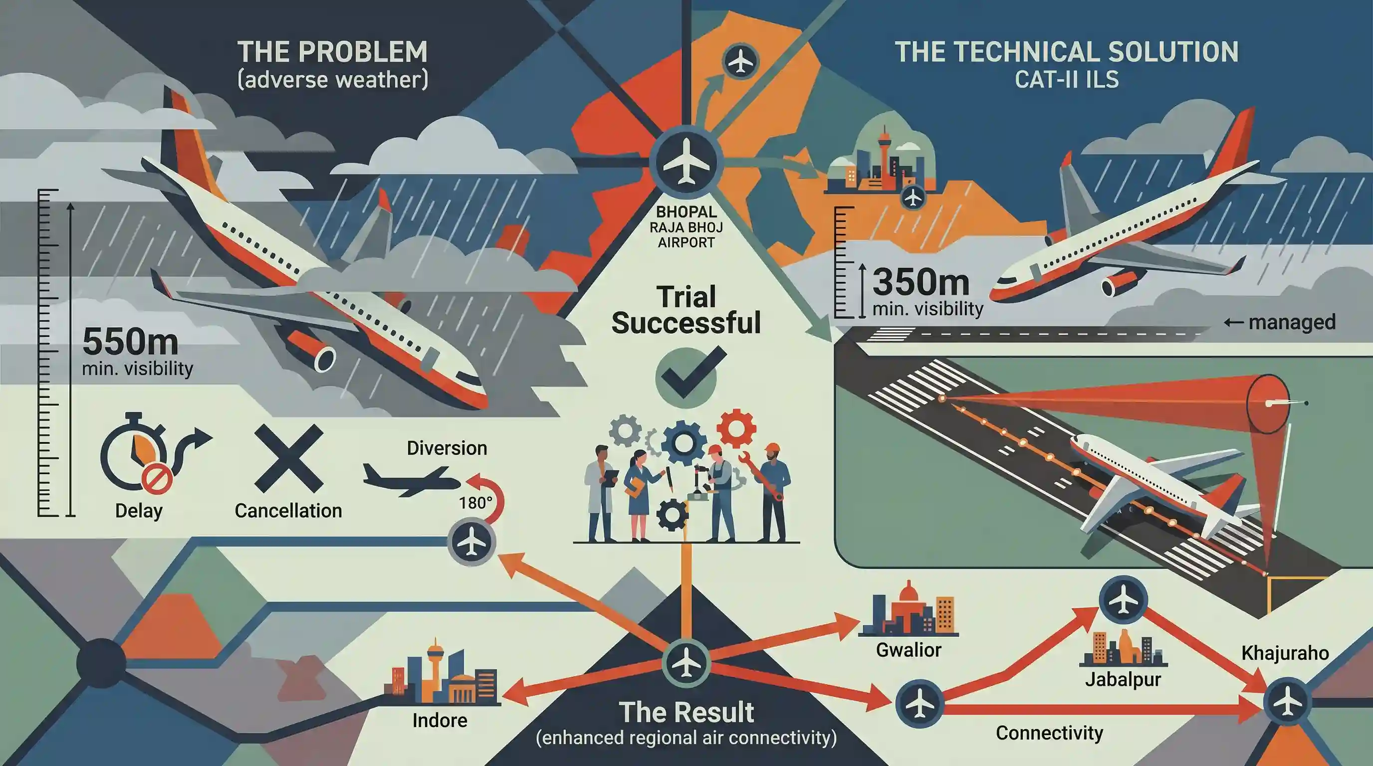
Bhopal's Raja Bhoj Airport has successfully completed trials for the Category-II (CAT-II) Instrument Landing System (ILS). The upgrade reduces the minimum visibility threshold required for aircraft landings from 550 metres to 350 metres. This major technical upgrade will significantly minimize flight delays, cancellations, and diversions caused by adverse weather conditions such as dense fog and heavy rain, enhancing regional air connectivity in Madhya Pradesh.
Key Points
- Bhopal's Raja Bhoj Airport successfully completed the official trial of the Category-II (CAT-II) Instrument Landing System (ILS).
- Prior to this upgrade, the minimum runway visibility required for safe landing at Bhopal was 550 metres; the CAT-II system reduces this minimum required visibility to 350 metres.
- The upgraded technology will prevent flight delays, cancellations, and diversions during heavy rains and dense winter fog, ensuring seamless flight operations in the capital of Madhya Pradesh.
- This technology represents a major stride in the aviation infrastructure of Madhya Pradesh, which has increasingly focused on improving its connectivity and airport capability.
Important Terms
Airports Authority of India (AAI)

A statutory body under the Ministry of Civil Aviation responsible for creating, upgrading, maintaining, and managing civil aviation infrastructure and providing air traffic management services over Indian airspace.
UPSC context
GS Paper 2 (Statutory Bodies) and GS Paper 3 (Infrastructure); tests understanding of civil aviation infrastructure governance in India.
Instrument Landing System (ILS)
A ground-based radio navigation system providing precision horizontal and vertical guidance to aircraft approaching a runway, enabling safe landings in low-visibility or adverse weather.
UPSC context
GS Paper 3 (Science and Technology); tests knowledge of safety-critical navigation systems and disaster-resilient infrastructure.
Category-II Instrument Landing System (CAT-II ILS)
A high-precision standard of Instrument Landing System allowing aircraft to land in poor weather down to a Runway Visual Range as low as 300 to 350 meters.
UPSC context
GS Paper 3 (Infrastructure: Aviation); tests understanding of modernized technological standards boosting regional air connectivity.
Directorate General of Civil Aviation (DGCA)
India's statutory civil aviation regulatory body, responsible for safety oversight, airworthiness standards, licensing personnel, certifying aerodromes, and enforcing civil air regulations.
UPSC context
GS Paper 2 (Regulatory Bodies) and GS Paper 3 (Infrastructure); tests knowledge of aviation safety oversight and regulatory frameworks.
Runway Visual Range (RVR)
The distance over which a pilot aligned on a runway centerline can see markings or delineating lights, determining landing and takeoff criteria during low visibility.
UPSC context
GS Paper 3 (Applied Science and Transport); tests technical awareness of landing parameters in foggy weather conditions.
Prelims Trap
CAT-II Instrument Landing System (ILS) enables completely blind landings with zero-visibility and zero-decision height requirements.
CAT-II still requires a minimum visibility of 350m and a 30m decision height. Only CAT-IIIc allows zero-visibility/zero-decision height operations.
Static Concepts Connected
What is an Instrument Landing System (ILS) and how does it function?
- Dual-Signal Guidance: Uses a Localizer (VHF) for lateral alignment and a Glide Path (UHF) for vertical descent guidance.
- Marker Beacons: Uses ground-based VHF radio beacons to provide distance markers to the runway threshold.
- Category Thresholds: Divides systems into CAT-I, II, and III based on minimum visibility and decision height requirements.
Who was Raja Bhoj of the Paramara Dynasty?
- Paramara Dynasty: 11th-century polymath king of the Paramara dynasty of Malwa, ruling from his capital at Dhar.
- Literary Contributions: Authored seminal Sanskrit treatises such as Samarangana Sutradhara (architecture) and Sringara-prakasha (poetics).
- Bhojeshwar Temple: Founded the historic city of Bhopal, built the Bhojtal lake, and constructed the colossal unfinished temple at Bhojpur.
Cross-Topic Patterns
Aviation tech + Winter smog crises
Severe winter smog in Indo-Gangetic plains links flight disruptions to agricultural residue burning, requiring high-category ILS upgrades to maintain regional air connectivity.
Paramara architecture + Medieval literature
Study of Raja Bhoj's Samarangana Sutradhara links classical Vastu Shastra to medieval temple engineering, a frequent theme in UPSC Art & Culture.

Radio spectrum bands of ILS (VHF/UHF) or the architectural legacy of Raja Bhoj are prime candidates for multi-disciplinary GS questions.
Linked PYQs · 2
Linked PYQs · 2
- 2021MPPSC_PRELIMSGS1
Which of the following Airports is/are not International Airport ? 1. Bhopal 2. Indore 3. Khajuraho 4. Gwalior Select the correct answer using codes given below : Codes :
- 2019MPPSC_PRELIMSGS1
Which Airport is non-operational in Madhya Pradesh ?
