Coimbatore Urbanization and Agricultural Land Use Changes
Source:The Hindu ↗
Why It Matters
It provides a clear micro-level case study on the impact of urban expansion on agricultural land use and changing cropping patterns, which are crucial themes in GS1 (Urbanization) and GS3 (Agriculture and Cropping Patterns).
Summary
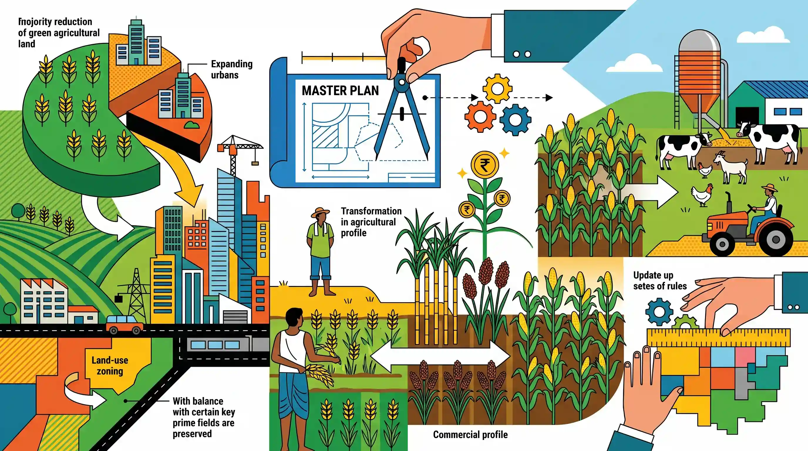
The proposed Coimbatore Master Plan - 2041 forecasts a significant reduction in agricultural land within the Local Planning Area, projecting a decline from 59.62% to 45.83% by 2041 driven by rapid urbanization. The plan aims to balance development by retaining prime agricultural lands. Concurrently, the region is witnessing a transformation in its agricultural profile, marked by a shift away from traditional crops such as paddy towards commercial crops like sugarcane and ragi, alongside increased maize cultivation that supports livestock farming. Land-use zoning is also being updated to comply with the Tamil Nadu Combined Development and Building Rules 2019.
Key Points
- Agricultural land in the Coimbatore Local Planning Area (LPA) is projected to decline from 59.62% to 45.83% by 2041 due to urbanization.
- Despite the reduction, prime agricultural lands are intended to be preserved within the agricultural use zone.
- The region is experiencing a shift in cropping patterns, with a decline in traditional crops like groundnut and paddy, and an increase in commercial crops like sugarcane, red gram, and ragi.
- Increased cultivation of crops like maize and sorghum is directly boosting the local livestock sector.
- The Master Plan aligns land-use categories with the Tamil Nadu Combined Development and Building Rules 2019, streamlining zoning classifications.
Important Terms
Coimbatore Master Plan - 2041

A GIS-based statutory blueprint for Coimbatore’s urban growth through 2041. It regulates land use and infrastructure to balance rapid industrial/residential expansion with the preservation of prime agricultural zones.
UPSC context
GS-I (Urbanization) and GS-III (Land Use). Tests regional planning strategies and the conflict between urban sprawl and agricultural conservation.
Tamil Nadu Combined Development and Building Rules 2019
A unified code consolidating building and planning regulations across Tamil Nadu. It streamlines approval processes, enforces structural safety, and promotes sustainable development via standardized floor space and zoning norms.
UPSC context
GS-I/III (Governance/Infrastructure). Tests knowledge of administrative reforms in urban management and regulatory standards for safe, inclusive cities.
Local Planning Authority (LPA)
A statutory body constituted under the Town and Country Planning Act (e.g., TN 1971 Act) responsible for preparing master plans and enforcing land-use regulations within a notified region.
UPSC context
GS-II (Local Governance). Tests understanding of the institutional framework for decentralized urban and regional planning in India.
Cropping Pattern
The proportion of area under various crops at a given point in time. It reflects regional agricultural systems, influenced by climate, market demand, and technological shifts.
UPSC context
GS-III (Agriculture). A core syllabus topic testing awareness of crop diversification, commercialization, and their impact on food security.
Land-use Zoning
A planning technique that divides land into zones (residential, industrial, agricultural) where specific uses are permitted, used to manage urban growth and protect resources from conflicting developments.
UPSC context
GS-I/III (Urbanization/Environment). Relevant for discussing urban sprawl, planned development, and the conservation of ecologically sensitive or agricultural lands.
Prelims Trap
Urban expansion in peripheral areas strictly reduces all crop cultivation, including commercial and fodder crops, due to absolute land scarcity.
Urbanization actually spurs a shift towards commercial, vegetable, and fodder crops in peri-urban zones to meet urban consumption demands, rather than halting all cultivation.
Static Concepts Connected
What are the key features of Peri-Urban Agriculture?
- Market Proximity: Oriented towards supplying perishable, high-demand goods like dairy, vegetables, and meat to nearby urban centers.
- Cropping Shift: Transitions from traditional staple grains to high-value commercial crops, horticulture, and fodder.
- Resource Intensity: Relies heavily on intensive input use, often utilizing recycled urban wastewater for irrigation.
What are the key standard Land Use Classifications in India?
- Net Sown Area: The physical extent of land on which crops are sown and harvested at least once a year.
- Non-Agricultural Uses: Lands occupied by buildings, roads, railways, and industries, which expands rapidly during urban sprawl.
- Fallow Lands: Cultivable lands kept temporarily out of cultivation for one to five years to regain natural fertility.
Cross-Topic Patterns
Urban Sprawl + Cropping Patterns
Expanding built environments force peri-urban farmers to swap land-intensive staples for high-yield commercial crops and dairy fodder, linking GS1 urbanization to GS3 agriculture.
Master Plans + 74th Amendment
Zoning and preserving peri-urban agriculture through Master Plans highlights the constitutional role of District and Metropolitan Planning Committees in spatial planning.

Expect a GS3 question linking rapid peri-urbanization to changing cropping patterns, specifically the shift to fodder and commercial crops.
Linked PYQs · 3
Linked PYQs · 3
- 2023MainsGS3
Explain the changes in cropping pattern in India in the context of changes in consumption pattern and marketing conditions.
- 2021MainsGS3
What are the present challenges before crop diversification? How do emerging technologies provide an opportunity for crop diversification?
- 2021MainsGS1
What are the environmental implications of the reclamation of water bodies into urban land use ? Explain with examples.
