గోదావరి డెల్టా ఆధునీకరణ ప్రాజెక్టును ఆమోదించిన ఏపీ ప్రభుత్వం
Source:times-of-india ↗
ఇది ఎందుకు ముఖ్యం
The modernization of river deltas and the management of coastal challenges like seawater intrusion are vital geographical and economic topics. Understanding these state-specific irrigation initiatives is crucial for APPSC Prelims, particularly regarding the Godavari basin and agricultural resilience.
సారాంశం
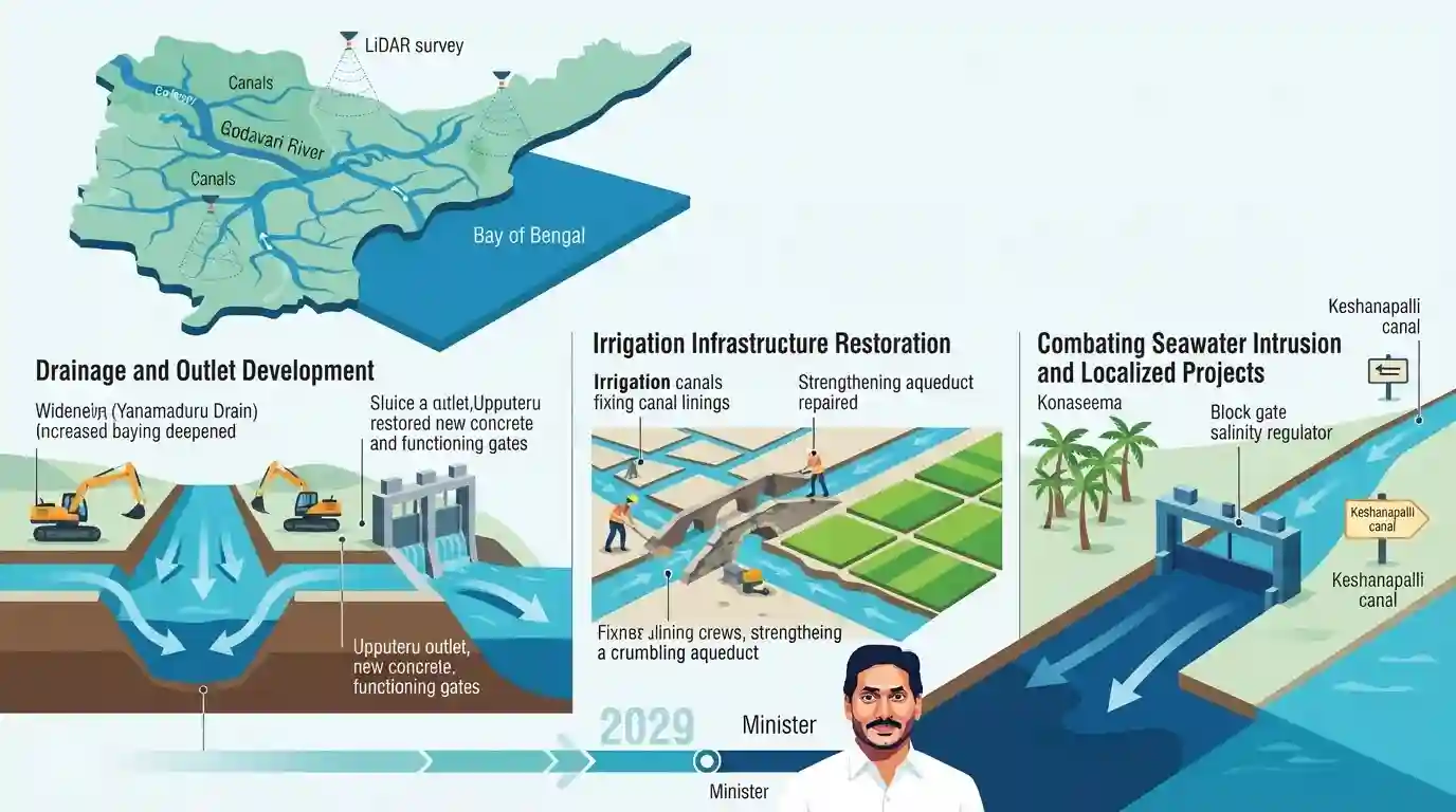
2029 నాటికి పూర్తి చేయడమే లక్ష్యంగా గోదావరి డెల్టా సమగ్ర ఆధునీకరణ ప్రణాళికను ఆంధ్రప్రదేశ్ ప్రభుత్వం ఆమోదించింది. జలవనరుల శాఖ మంత్రి నిమ్మల రామానాయుడు సారథ్యంలో సాగుతున్న ఈ ప్రాజెక్టులో యనమదురు వంటి ప్రధాన డ్రైన్ల సామర్థ్యాన్ని పెంచడం, ఉప్పుటేరు అవుట్లెట్ను అభివృద్ధి చేయడం మరియు దెబ్బతిన్న సాగునీటి నిర్మాణాలను పునరుద్ధరించడం వంటి పనులు ఉన్నాయి. ఇప్పటికే పూర్తయిన LiDAR సర్వే ఆధారంగా చేపడుతున్న ఈ చొరవలో రాజోలులోని కేశనపల్లి కాలువ ప్రాజెక్టు వంటి స్థానిక పనులతో పాటు, కోనసీమ జిల్లాలో మంచినీటి వనరులకు మరియు కొబ్బరి తోటలకు ముప్పుగా పరిణమించిన సముద్రపు నీటి చొరబాటును నిరోధించడానికి రూ. 50 కోట్ల పథకం కూడా చేర్చబడింది.
ముఖ్య అంశాలు
- The Andhra Pradesh government has committed to completing the Godavari delta modernisation project by 2029.
- యనమదుర్రు డ్రైన్ సామర్థ్యం 23,000 నుండి 30,000 క్యూసెక్కులకు పెంచబడుతుంది, మరియు ఉప్పుటేరు అవుట్లెట్ అభివృద్ధి చేయబడుతుంది.
- A LiDAR survey has been completed to aid in modernizing the extensive canal and drainage networks.
- The Keshanapalli canal project will be implemented to irrigate 2,686 acres in the Rajole constituency.
- A Rs 50-crore project will address seawater intrusion in Konaseema villages, which has previously damaged coconut plantations and fresh water supplies.
ముఖ్యమైన పదాలు
Godavari Delta Modernisation Project

A comprehensive state infrastructure initiative targeted for completion by 2029. It focuses on upgrading canals, expanding drain capacities, and restoring agricultural water systems across the Godavari delta using LiDAR surveys.
UPSC context
AP Economy & Geography. Tests knowledge of major state irrigation policies, agricultural infrastructure, and modernization timelines.
Yanamaduru Drain
A vital drainage system in the West Godavari delta frequently challenged by excess floodwaters and industrial pollution. The government is upgrading its carrying capacity from 23,000 to 30,000 cusecs.
UPSC context
AP Geography & Disaster Management. Tests awareness of regional flood control systems, river networks, and local pollution challenges.
Upputeru Outlet
కొల్లేరు సరస్సు మరియు యనమదుర్రు డ్రెయిన్ను బంగాళాఖాతంతో అనుసంధానించే ప్రధాన సహజ ప్రవాహ మార్గం. పంటలు ముంపునకు గురికాకుండా నివారించడానికి మరియు వరద నీటిని నిర్వహించడానికి దీని పూడికతీత (డ్రెడ్జింగ్) మరియు అభివృద్ధి అత్యంత కీలకం.
UPSC context
AP Geography & Environment. Crucial for understanding the Kolleru Lake ecosystem, deltaic drainage networks, and coastal wetland conservation.
Seawater Intrusion (Konaseema)
తీరప్రాంత కాలువల ద్వారా ఉప్పు సముద్రపు నీరు భూభాగంలోకి ప్రవహించి, మంచినీటి వనరులను కలుషితం చేస్తూ, కోనసీమలోని విస్తారమైన కొబ్బరి తోటల వంటి వ్యవసాయ సంపదను తీవ్రంగా దెబ్బతీసే ఒక పర్యావరణ ముప్పు.
UPSC context
AP Environment & Disaster Management. Tests understanding of coastal vulnerabilities, climate impacts, and agricultural threats in delta regions.
Keshanapalli Canal Project
కోనసీమ జిల్లాలోని రాజోలు నియోజకవర్గంలో 2,686 ఎకరాల నూతన ఆయకట్టును సాగులోకి తీసుకురావడానికి మరియు తీవ్రమైన లవణీయత సమస్యలను ఎదుర్కొంటున్న గ్రామాలకు మంచినీటిని సరఫరా చేయడానికి రూపొందించిన ఒక స్థానిక నీటిపారుదల పథకం.
UPSC context
AP Economy & Regional Development. Highlights government interventions for localized agriculture, freshwater access, and rural water security.
LiDAR Survey in Irrigation
Light Detection and Ranging technology utilized by the state government to accurately map topographies and prepare detailed project reports (DPRs) for modernizing the Godavari delta canals and drains.
UPSC context
Science & Technology / AP Governance. Tests the application of modern remote sensing and mapping technologies in state infrastructure planning.
ప్రిలిమ్స్ ఉచ్చు
"The Upputeru river is a distributary of the Godavari that supplies fresh water to Kolleru Lake."
Upputeru is not a distributary feeding Kolleru Lake; it is the sole natural outlet that drains excess floodwater from Kolleru into the Bay of Bengal.
అనుసంధానమైన స్థిర భావనలు
How does the Upputeru river function in the Godavari-Krishna drainage system?
- ఏకైక విక్రయ కేంద్రం: ఇది కొల్లేరు సరస్సుకు గల ఏకైక సహజ నిష్క్రమణ మార్గంగా పనిచేస్తూ, అదనపు వరద నీటిని బంగాళాఖాతంలోకి విడుదల చేస్తుంది.
- Inter-deltaic Location: Kolleru is a shallow freshwater lake strategically located in the depression between the deltas of the Krishna and Godavari rivers.
- Tidal Influence: It is a meandering tidal channel, which makes the connected wetland and deltaic ecosystems vulnerable to salinity intrusion during high tides or storm surges.
కోనసీమ వంటి తీరప్రాంత వ్యవసాయ హబ్లలో సముద్రపు నీటి చొరబాటును ఏది ప్రేరేపిస్తోంది?
- Groundwater Depletion: Over-extraction of fresh groundwater for intensive agriculture lowers the hydrostatic pressure, allowing heavier saline ocean water to push inland into aquifers.
- Reduced River Discharge: Reduced downstream river flow due to dams and barrages limits the freshwater push needed to keep the saltwater wedge at bay in estuaries.
- వ్యవసాయ ప్రభావం: Rising soil salinity severely damages salt-sensitive cash crops like coconuts and paddy, which are economic staples of the Konaseema region.
అంతర-అంశ నమూనాలు
నీటిపారుదల నిర్మాణాలు + చిత్తడి నేలల ఆవరణశాస్త్రం
The modernization of drains emptying into the Upputeru river directly impacts the flood dynamics and salinity levels of Kolleru Lake, linking irrigation infrastructure to Ramsar wetland conservation.
Spatial Tech in AP Governance
AP's deployment of LiDAR for canal modernization reflects a growing syllabus trend: the application of spatial technologies (remote sensing, GIS, LiDAR) in state governance and disaster management.

Expect matching questions pairing AP drainage channels (Upputeru, Yanamaduru) with their geographical function or associated water bodies.
అనుసంధాన PYQలు · 4
అనుసంధాన PYQలు · 4
- 2023APPSC_PRELIMSGS1
Apex Council of Godavari and Krishna river water resources and their management consists of
- 2024APPSC_PRELIMSGS1
In Andhra Pradesh, Dharwar types of rocks are found in:
- 2024APPSC_PRELIMSGS1
Within India, Ganga river basin has the largest catchment area. After that, following is the correct sequence in the decreasing order:
- 2023APPSC_PRELIMSGS1
Match the following Irrigation Projects and their States (location): | Irrigation Projects | States | |---|---| | a. Parwan Multipurpose Project | I. Madhya Pradesh | | b. Renukaji Dam Project | II. Uttarakhand | | c. Lakhwar | III. Himachal Pradesh | | d. Ken-Betwa Link Project | IV. Rajasthan | Choose the correct answer using the codes given below: Code: a b c d
