AP government approves godavari delta modernisation project
Source:times-of-india ↗
Why It Matters
The modernization of river deltas and the management of coastal challenges like seawater intrusion are vital geographical and economic topics. Understanding these state-specific irrigation initiatives is crucial for APPSC Prelims, particularly regarding the Godavari basin and agricultural resilience.
Summary
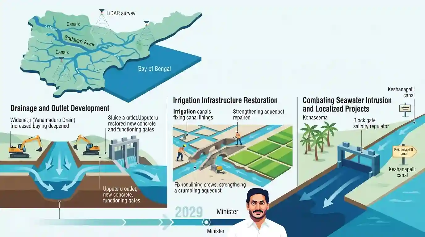
The Andhra Pradesh government has approved a comprehensive modernization plan for the Godavari delta, targeted for completion by 2029. Spearheaded by Water Resources Minister Nimmala Ramanaidu, the project involves increasing the capacity of major drains like Yanamaduru, developing the Upputeru outlet, and restoring damaged irrigation structures. Backed by a completed LiDAR survey, the initiative also includes localized interventions such as the Keshanapalli canal project in Rajole and a Rs 50-crore scheme to combat seawater intrusion that threatens fresh water resources and coconut plantations in the Konaseema district.
Key Points
- The Andhra Pradesh government has committed to completing the Godavari delta modernisation project by 2029.
- The capacity of the Yanamaduru drain will be increased from 23,000 to 30,000 cusecs, and the Upputeru outlet will be developed.
- A LiDAR survey has been completed to aid in modernizing the extensive canal and drainage networks.
- The Keshanapalli canal project will be implemented to irrigate 2,686 acres in the Rajole constituency.
- A Rs 50-crore project will address seawater intrusion in Konaseema villages, which has previously damaged coconut plantations and fresh water supplies.
Important Terms
Godavari Delta Modernisation Project

A comprehensive state infrastructure initiative targeted for completion by 2029. It focuses on upgrading canals, expanding drain capacities, and restoring agricultural water systems across the Godavari delta using LiDAR surveys.
UPSC context
AP Economy & Geography. Tests knowledge of major state irrigation policies, agricultural infrastructure, and modernization timelines.
Yanamaduru Drain
A vital drainage system in the West Godavari delta frequently challenged by excess floodwaters and industrial pollution. The government is upgrading its carrying capacity from 23,000 to 30,000 cusecs.
UPSC context
AP Geography & Disaster Management. Tests awareness of regional flood control systems, river networks, and local pollution challenges.
Upputeru Outlet
The primary natural outlet connecting Kolleru Lake and the Yanamaduru drain to the Bay of Bengal. Its dredging and development are critical to preventing crop inundation and managing floodwaters.
UPSC context
AP Geography & Environment. Crucial for understanding the Kolleru Lake ecosystem, deltaic drainage networks, and coastal wetland conservation.
Seawater Intrusion (Konaseema)
An environmental hazard where saline sea water flows inland through coastal drains, contaminating freshwater sources and severely damaging agricultural assets like Konaseema's extensive coconut plantations.
UPSC context
AP Environment & Disaster Management. Tests understanding of coastal vulnerabilities, climate impacts, and agricultural threats in delta regions.
Keshanapalli Canal Project
A localized irrigation scheme in the Rajole constituency of Konaseema district designed to cultivate 2,686 acres of new ayacut and supply freshwater to villages facing acute salinity issues.
UPSC context
AP Economy & Regional Development. Highlights government interventions for localized agriculture, freshwater access, and rural water security.
LiDAR Survey in Irrigation
Light Detection and Ranging technology utilized by the state government to accurately map topographies and prepare detailed project reports (DPRs) for modernizing the Godavari delta canals and drains.
UPSC context
Science & Technology / AP Governance. Tests the application of modern remote sensing and mapping technologies in state infrastructure planning.
Prelims Trap
"The Upputeru river is a distributary of the Godavari that supplies fresh water to Kolleru Lake."
Upputeru is not a distributary feeding Kolleru Lake; it is the sole natural outlet that drains excess floodwater from Kolleru into the Bay of Bengal.
Static Concepts Connected
How does the Upputeru river function in the Godavari-Krishna drainage system?
- Sole Outlet: It acts as the only natural outlet for Kolleru Lake, discharging excess floodwater into the Bay of Bengal.
- Inter-deltaic Location: Kolleru is a shallow freshwater lake strategically located in the depression between the deltas of the Krishna and Godavari rivers.
- Tidal Influence: It is a meandering tidal channel, which makes the connected wetland and deltaic ecosystems vulnerable to salinity intrusion during high tides or storm surges.
What drives seawater intrusion in coastal agricultural hubs like Konaseema?
- Groundwater Depletion: Over-extraction of fresh groundwater for intensive agriculture lowers the hydrostatic pressure, allowing heavier saline ocean water to push inland into aquifers.
- Reduced River Discharge: Reduced downstream river flow due to dams and barrages limits the freshwater push needed to keep the saltwater wedge at bay in estuaries.
- Agricultural Impact: Rising soil salinity severely damages salt-sensitive cash crops like coconuts and paddy, which are economic staples of the Konaseema region.
Cross-Topic Patterns
Irrigation structures + Wetland ecology
The modernization of drains emptying into the Upputeru river directly impacts the flood dynamics and salinity levels of Kolleru Lake, linking irrigation infrastructure to Ramsar wetland conservation.
Spatial Tech in AP Governance
AP's deployment of LiDAR for canal modernization reflects a growing syllabus trend: the application of spatial technologies (remote sensing, GIS, LiDAR) in state governance and disaster management.

Expect matching questions pairing AP drainage channels (Upputeru, Yanamaduru) with their geographical function or associated water bodies.
Linked PYQs · 4
Linked PYQs · 4
- 2023APPSC_PRELIMSGS1
Apex Council of Godavari and Krishna river water resources and their management consists of
- 2024APPSC_PRELIMSGS1
In Andhra Pradesh, Dharwar types of rocks are found in:
- 2024APPSC_PRELIMSGS1
Within India, Ganga river basin has the largest catchment area. After that, following is the correct sequence in the decreasing order:
- 2023APPSC_PRELIMSGS1
Match the following Irrigation Projects and their States (location): | Irrigation Projects | States | |---|---| | a. Parwan Multipurpose Project | I. Madhya Pradesh | | b. Renukaji Dam Project | II. Uttarakhand | | c. Lakhwar | III. Himachal Pradesh | | d. Ken-Betwa Link Project | IV. Rajasthan | Choose the correct answer using the codes given below: Code: a b c d
