Flood Fury Grips Uttar Pradesh After Heavy Monsoon Rains
Source:uni-india ↗
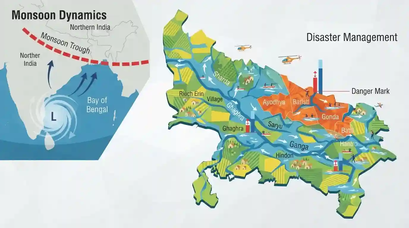
Why It Matters
Understanding the behavior of regional river systems (like Sharda, Ghaghra, and Hindon) and Indian monsoon mechanisms (monsoon troughs, low-pressure zones) is crucial for the UPPSC Prelims Geography and Disaster Management sections. Questions frequently test knowledge of river courses and monsoon rainfall distribution.
Summary
Following torrential rains, Uttar Pradesh is experiencing severe flood conditions with major rivers like the Sharda, Ghaghra, Saryu, Ganga, and Hindon swelling significantly. The Central Water Commission has indicated that several rivers are flowing above the danger or warning marks, inundating low-lying regions in districts such as Ayodhya, Gonda, and Basti. The heavy precipitation is meteorologically attributed to the weakening of a low-pressure area over the Bay of Bengal combined with the southward shifting of the monsoon trough. The situation highlights the state's vulnerability to monsoon-induced riverine flooding.
Key Points
- Severe flooding has struck Uttar Pradesh due to torrential rainfall driven by shifting monsoon dynamics.
- Major rivers, including the Sharda (Lakhimpur Kheri), Ghaghra (Sonbhadra), Ganga (Varanasi), Saryu (Ayodhya), and Hindon (Noida), are swelling above warning or danger marks.
- The Central Water Commission reported that the Sharda and Hindon rivers crossed the danger mark.
- The intense rainfall was triggered by the weakening of a low-pressure area over the Bay of Bengal and the southward shift of the monsoon trough.
- Mirzapur recorded the highest rainfall, causing widespread inundation in low-lying areas of eastern and central Uttar Pradesh.
Important Terms
Central Water Commission

India's premier technical organization in water resources under the Ministry of Jal Shakti, responsible for coordinating flood control, irrigation, navigation, and water conservation schemes across states.
UPSC context
GS Paper III (Disaster Management); tests institutional frameworks, flood forecasting, and national water resource management.
Monsoon Trough
An elongated low-pressure zone over the Indo-Gangetic Plains during the southwest monsoon, whose northward or southward shifts dictate the distribution and intensity of rainfall.
UPSC context
GS Paper I (Physical Geography); tests climatology, southwest monsoon mechanisms, and precipitation variability.
Riverine Flooding
Flooding that occurs when a river or stream overflows its natural banks due to excessive rainfall or snowmelt in the catchment area, submerging adjacent dry land.
UPSC context
GS Paper III (Disaster Management); tests flood hazards, vulnerable geographic regions, and disaster mitigation strategies.
Ghaghra River
A perennial, trans-boundary left-bank tributary of the Ganga originating near Lake Mansarovar. It is the Ganges' largest tributary by volume and flows through Nepal and northern India.
UPSC context
GS Paper I (Indian Geography); tests northern river systems, trans-boundary water courses, and drainage basin features.
Saryu River
A Himalayan river flowing through Uttarakhand and Uttar Pradesh. Its lower course is the name commonly given to the Ghaghra River, particularly as it flows past Ayodhya.
UPSC context
GS Paper I (Geography/Culture); tests major river networks, cultural significance of rivers, and regional hydrology.
Prelims Trap
"A northward shift of the monsoon trough triggers torrential rainfall across the central Indo-Gangetic plains."
A northward shift causes a 'break' monsoon, drying the plains while flooding the Himalayan foothills. It is the southward shift that brings active rain to the plains.
Static Concepts Connected
How does the shifting of the monsoon trough affect Indian rainfall distribution?
- Southward Shift: Moves over the Indo-Gangetic plains, drawing moist sea winds and triggering active, widespread rainfall across central and northern India.
- Northward Shift: Moves toward the Himalayan foothills, causing 'break-monsoon' dry spells in the plains while triggering heavy rainfall and floods in the sub-Himalayan region.
What are the key geographical traits of the Ghaghra and Sharda rivers?
- Ghaghra River: Originates near Mansarovar in Tibet; known as Saryu in lower Awadh. It is the largest Ganga tributary by volume, joining it at Chhapra in Bihar.
- Sharda (Kali) River: Originates at Kalapani on the Indo-Nepal border, flows through the Terai plains, and merges with the Ghaghra at Brahmaghat in Uttar Pradesh.
Cross-Topic Patterns
Dead rivers & urban flooding
Hindon's overflow highlights the dual crisis of climate extremes and river pollution. As a 'dead river' with zero DO, its floodwaters pose severe biohazard and health risks to NCR regions like Noida.
CWC and institutional water governance
The Central Water Commission's flood alerts intersect with Disaster Management. Established in 1945 on Dr. B.R. Ambedkar's advice, CWC's interstate basin role frequently anchors mains questions on river governance.

Expect a prelims mapping question linking left-bank Ganga tributaries (Sharda, Ghaghra) with monsoon trough 'active' vs 'break' phases.
Linked PYQs · 4
Linked PYQs · 4
- 2019UPPSC_PRELIMSGS1
In which of the following rivers, the upper course contains fresh water but saline water flowing at the lower part?
- 2023UPPSC_PRELIMSGS1
Assertion (A) – The Tamil Nadu coast remains dry during South-West monsoon season. Reason (R) – The Tamil Nadu coast is situated parallel to the Bay of Bengal branch of South-West monsoon and it lies in the rain shadow area of the Arabian Sea branch of the South-West monsoon during monsoon season. the correct answering the code given below –
- 2009UPPSC_PRELIMSGS1
The State having the highest rainfall by North East Monsoon is
- 2021UPPSC_PRELIMSGS1
Which one of the following causes is responsible for rainfall during winters in north-western part of India ?
