Satellite Monitoring Discrepancies in Stubble Burning Estimates
Source:The Hindu ↗
Why It Matters
The article demonstrates the practical limitations of satellite monitoring in environmental governance and the ingenuity of actors evading compliance. It highlights the critical difference between geostationary and polar satellite orbits in remote sensing, emphasizing the need for accurate metrics (burnt area vs. fire counts) in public policy and accountability for tackling Delhi-NCR air pollution.
Summary
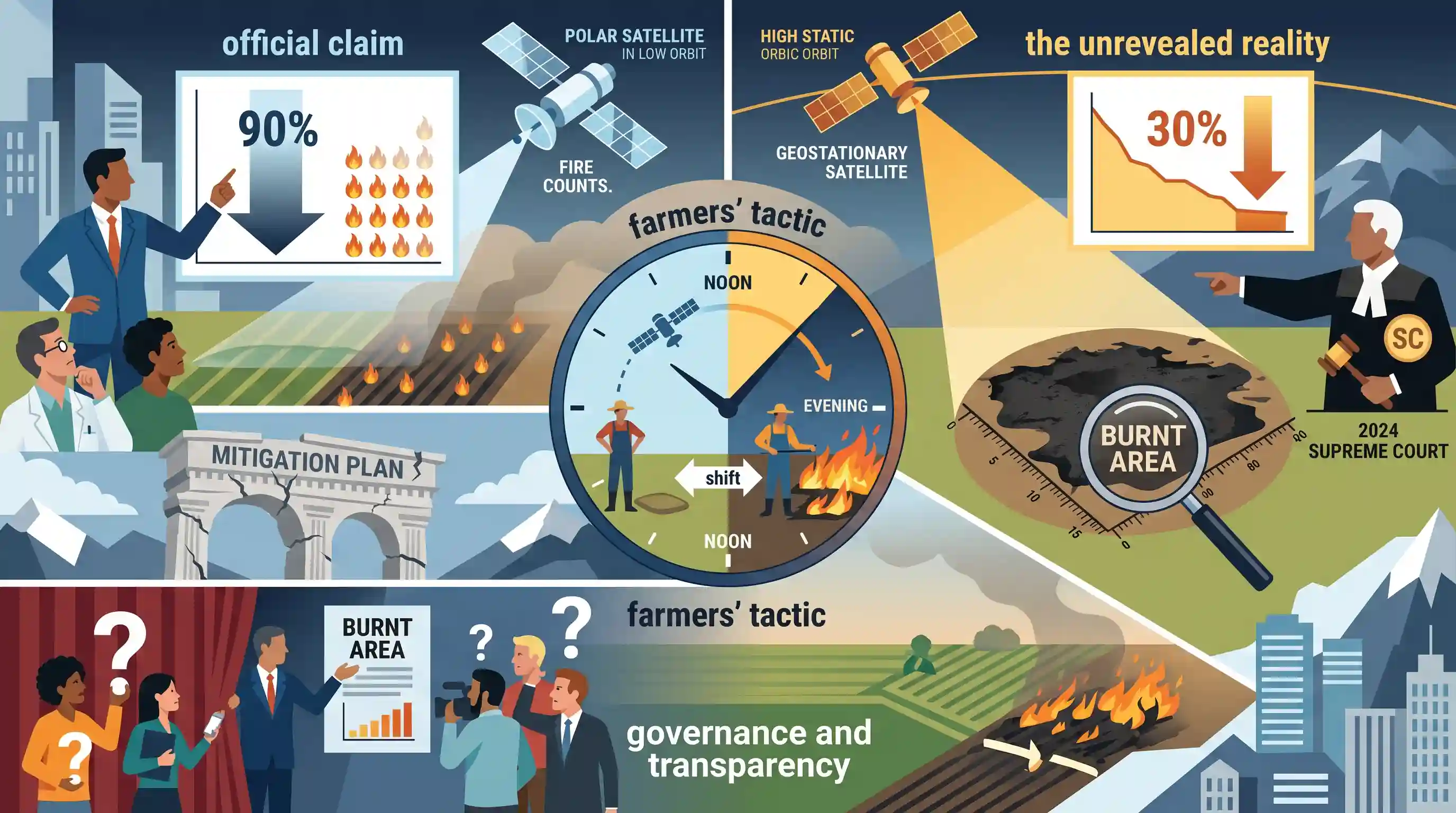
The editorial highlights a significant discrepancy in the Indian government's claims regarding stubble burning reduction in Punjab and Haryana. While the Environment Ministry asserts a 90% decline based on fire counts from polar satellites, 'burnt area' estimates show only a 30% reduction. This gap is attributed to farmers strategically shifting stubble burning to the evening to evade detection by polar satellites, a tactic exposed by continuous observation from geostationary satellites. Despite a 2024 Supreme Court directive mandating the use of 'burnt area' metrics, the government has yet to make these figures public, prompting concerns that relying on flawed data undermines public confidence in air pollution mitigation efforts.
Key Points
- The Environment Ministry claimed a 90% drop in farm fires in Punjab and Haryana between 2022 and 2025, relying on fire-count data from polar satellites.
- Independent 'burnt area' estimates indicate a much lower reduction of 30% (from 31,500 sq km to 19,700 sq km) over the same period.
- Data from geostationary satellites (like Meteosat) revealed that farmers have shifted stubble burning to the evening to deliberately evade polar satellites, which pass over India between 10 a.m. and 1:30 p.m.
- Despite a 2024 Supreme Court directive instructing the Environment Ministry to use 'burnt area' metrics rather than fire counts, the government has not made these estimates public.
- The editorial warns that persisting with misleading fire-count metrics risks eroding public trust in broader efforts to mitigate air pollution in the region.
Important Terms
Burnt Area (Metrics)

The measurement of total land surface showing physical evidence of fire. It provides a more accurate estimate of biomass consumed and emissions than momentary fire counts.
UPSC context
GS III: Science & Tech. Tests knowledge of remote sensing accuracy in environmental governance and pollution monitoring.
Polar-orbiting Satellites
Satellites (e.g., NASA’s MODIS) that circle the Earth over the poles. They observe regions only at fixed 'overpass' times, which farmers sometimes exploit by burning stubble in the evening.
UPSC context
GS III: Science & Tech. Tests understanding of satellite types and the limitations of time-specific environmental observation.
Geostationary Satellites
Satellites (e.g., INSAT-3DS) that stay fixed over one spot, providing continuous 24/7 observation. They are essential for detecting fire activity that occurs outside the surveillance windows of polar satellites.
UPSC context
GS III: Science & Tech. Important for real-time monitoring and disaster management topics in the UPSC syllabus.
Supreme Court of India
India’s apex court, which in 2024 mandated 24x7 monitoring and 'burnt area' metrics for stubble burning to uphold the Right to Clean Air under Article 21.
UPSC context
GS II: Polity. Tests understanding of judicial activism and the enforcement of Fundamental Rights in environmental matters.
Ministry of Environment, Forest and Climate Change (MoEFCC)
The nodal Union ministry for environmental policy. It manages the Commission for Air Quality Management (CAQM) and reports stubble burning mitigation data to Parliament.
UPSC context
GS II: Governance. Relevant for executive bodies and their accountability in environmental conservation.
Stubble Burning (Parali)
The practice of setting fire to crop residues (paddy/wheat) to quickly clear fields for the next sowing cycle, contributing significantly to winter air pollution in North India.
UPSC context
GS III: Environmental Pollution. Tests understanding of agricultural externalities and their impact on regional air quality.
Crop Residue Management (CRM)
A policy framework providing subsidized machinery (e.g., Happy Seeders) and incentives for in-situ and ex-situ disposal of agricultural waste to prevent open field burning.
UPSC context
GS III: Agriculture. Tests knowledge of government schemes and technological interventions for sustainable farming.
Prelims Trap
Polar-orbiting remote sensing satellites provide continuous, real-time 24/7 monitoring of stubble burning incidents across India.
Polar satellites have fixed daily overpass times (e.g., late morning), creating blind spots. Geostationary satellites provide continuous 24/7 regional observation.
Static Concepts Connected
How do Polar and Geostationary satellites differ in earth observation capabilities?
- Orbit & Altitude: Polar orbits are lower (~600-800km); Geostationary orbits are placed much higher (~35,786km) directly over the equator.
- Temporal Resolution: Polar satellites pass over a region at fixed daily times. Geostationary satellites remain stationary relative to Earth, enabling continuous observation.
- Spatial Resolution: Because they are much closer to Earth, polar satellites generally provide higher spatial resolution images compared to geostationary satellites.
How does crop residue burning ecologically impact agricultural soil health?
- Microbial Death: The intense heat from burning destroys beneficial soil micro-organisms and fauna such as earthworms, severely stunting natural soil ecology.
- Nutrient Depletion: Burning causes significant loss of essential nutrients, completely destroying Nitrogen and Sulphur, and partially depleting Phosphorus and Potassium.
- Carbon Loss: The practice burns off vital soil organic carbon and rapidly depletes soil moisture, degrading long-term soil structure and fertility.
Cross-Topic Patterns
Judicial reliance on space tech
The Supreme Court mandating geostationary 'burnt area' data over flawed 'fire counts' highlights a rising trend: using independent satellite tech to enforce environmental governance and bypass manipulated state metrics.
Groundwater policies fueling winter smog
Laws delaying paddy sowing to save groundwater heavily compressed the harvest-to-sowing window. This policy success for water conservation inadvertently forced farmers to burn stubble for rapid turnaround.

Prelims 2026 will likely test the difference between polar and geostationary satellites applied to real-world environmental monitoring.
Linked PYQs · 3
Linked PYQs · 3
- 2019PrelimsGS1
For the measurement/estimation of which of the following are satellite images/remote sensing data used? 1. Chlorophyll content in the vegetation of a specific location 2. Greenhouse gas emissions from rice paddies of a specific location 3. Land surface temperatures of a specific location Select the correct answer using the code given below.
- 2011PrelimsGS1
Satellites used for telecommunication relay are kept in a geostationary orbit. A satellite is said to be in such an orbit when: 1. The orbit is geosynchronous. 2. The orbit is circular. 3. The orbit lies in the plane of the Earth's equator. 4. The orbit is at an altitude of 22,236 km.
- 2021MainsGS3
Describe the key points of the revised Global Air Quality Guidelines (AQGs) recently released by the World Health Organisation (WHO). How are these different from its last update in 2005? What changes in India's National Clean Air Programme are required to achieve these revised standards?
