Indonesia Earthquake Subduction Zone Seismicity and Tsunami Warnings
Source:Indian Express ↗
Why It Matters
The seismic event serves as a critical case study for understanding tectonic vulnerability within the Circum-Pacific Zone. It underscores the practical importance of oceanographic monitoring, real-time tsunami modeling, early warning dissemination, and coastal community preparedness to minimize loss of life during subduction-zone earthquakes.
Summary
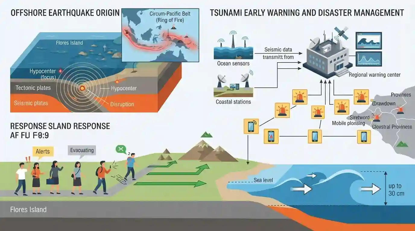
A shallow 7.7-magnitude earthquake struck off the north coast of Flores Island in eastern Indonesia, prompting tsunami warnings across several provinces. Residents evacuated to higher ground as sea levels temporarily receded and early tsunami waves up to 30 cm were detected. The event highlights Indonesia's vulnerability as part of the seismically active Pacific Ring of Fire.
Key Points
- A powerful 7.7-magnitude shallow earthquake struck off the coast of Flores Island in eastern Indonesia, with its epicentre located 68 kilometres northwest of Ende.
- The initial tremor was followed by strong aftershocks, including a major one measuring 6.1 magnitude, causing cracks in walls and prompting hospital and residential evacuations.
- Indonesia's BMKG issued a tsunami warning for East Nusa Tenggara, South Sulawesi, and West Nusa Tenggara provinces, predicting waves between 0.5 to 3 metres, with early waves of 19 to 30 cm detected.
- The physical phenomenon of the sea receding was observed by residents in Maumere prior to evacuating to higher ground.
- Indonesia's susceptibility to such disasters is due to its location on the Pacific 'Ring of Fire' (Circum-Pacific Belt), a zone of intense seismic and volcanic activity.
- The article draws parallels to historical disasters in the region, such as the catastrophic 9.1-magnitude 2004 Indian Ocean Tsunami, the 2018 Lombok earthquakes, and the 2018 Palu earthquake-tsunami.
Important Terms
Circum-Pacific Belt (Ring of Fire)

A 40,000-km horseshoe-shaped zone around the Pacific Ocean basin containing 75% of Earth's active volcanoes and 90% of its earthquakes, driven by tectonic plate subduction.
UPSC context
GS Paper 1 (Physical Geography); tested under tectonic activity and major geophysical phenomena.
Tsunami Early Warning System
An integrated technological network comprising seismic stations, bottom pressure recorders, and ocean buoys designed to detect undersea tsunamigenic earthquakes and transmit real-time hazard alerts.
UPSC context
GS Paper 3 (Disaster Management); tests ocean disaster mitigation and coastal preparedness technologies.
Shallow-Focus Earthquake
An earthquake originating at a depth of 0 to 70 kilometers underground. Because the seismic waves travel less distance, they cause higher-intensity surface shaking and destruction.
UPSC context
GS Paper 1 (Geophysical Phenomena); tests understanding of seismology, focal depths, and hazards.
Meteorology, Climatology, and Geophysics Agency of Indonesia (BMKG)
Indonesia's non-ministerial government agency tasked with providing meteorological, climatological, and geophysical services, specifically crucial for issuing regional earthquake and tsunami warnings.
UPSC context
GS Paper 3 (Disaster Management); tests international frameworks and bilateral partnerships in early warning.
US Geological Survey (USGS)
A scientific agency of the United States government that monitors and maps global seismic activity, providing critical real-time data on earthquake magnitudes and hazard risks worldwide.
UPSC context
GS Paper 3 (Disaster Management) and GS Paper 1; relevant to international disaster response networks.
Prelims Trap
"Tsunami waves possess maximum wave height (amplitude) in the deep ocean, which decreases near the coast."
Tsunamis have high speed but very LOW amplitude (height) in deep oceans, making them barely noticeable to ships. They only increase in height near coasts due to the shoaling effect.
Static Concepts Connected
What geological and physical conditions are required for an earthquake to generate a tsunami?
- Vertical Seafloor Displacement: Requires a thrust or reverse fault mechanism to vertically displace the water column. Strike-slip (horizontal) faults rarely trigger tsunamis.
- Shallow Focus Required: The earthquake must have a shallow focus (typically <70 km depth). Deep-focus earthquakes scatter energy in the mantle and fail to deform the ocean floor.
- Shoaling Effect: As long-period tsunami waves hit shallow coastal waters, their speed decreases but wavelength compresses, forcing the wave amplitude (height) to rise drastically.
How does India's Tsunami Early Warning System (ITEWS) function?
- Nodal Agency: Operated 24/7 by INCOIS (Hyderabad) under the Ministry of Earth Sciences.
- Bottom Pressure Recorders (BPRs): Deploys devices on the ocean floor to detect minor pressure variations in the water column (as small as 1 cm) caused by passing tsunami waves.
- Real-time Sensor Network: Integrates BPRs, coastal tide gauges, and land-based seismometers to confirm underwater triggers and avoid false alarms for coastal evacuations.
Cross-Topic Patterns
INCOIS + Regional Disaster Diplomacy
India's ITEWS acts as a Regional Tsunami Service Provider (RTSP) for the Indian Ocean Rim, making disaster warning systems a key soft-power pillar of India's SAGAR and Act East diplomacy.
Circum-Pacific Belt + Critical Minerals
The Pacific 'Ring of Fire' subduction zones directly dictate the tectonic formation of porphyry copper and lithium deposits, linking global earthquake geography to critical mineral supply chains.

Expect a multi-statement question contrasting tsunami wave mechanics (shoaling effect) with the role of INCOIS BPRs in early detection.
Linked PYQs · 3
Linked PYQs · 3
- 2025MainsGS1
What are Tsunamis? How and where are they formed? What are their consequences? Explain with examples.
- 2020MainsGS1
Discuss the geophysical characteristics of Circum-Pacific Zone.
- 2024MainsGS3
What is disaster resilience? How is it determined? Describe various elements of a resilience framework. Also mention the global targets of Sendai Framework for Disaster Risk Reduction (2015–2030).
